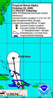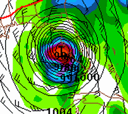
In a season chalk-full of unprecedented events in the Atlantic basin tropics…here’s something else that has never happened before…and quite frankly something that I never thought I’d ever see happen: More tropical storms/hurricanes than we have set names for. The genesis of “Alpha” occurred earlier today, a newly named tropical storm in the northeastern Carribean. It looks like this storm will not impact the east coast of the U.S. as a deep trough…the same trough that will take Wilma across Florida…will take Alpha out into the open Atlantic.
Speaking of Wilma… looks like Fort Myers/Naples are will get a good hit, likely coming in at a Cat 2… perhaps a low end Cat 3. Interesting the Oct22/18z GFS takes Wilma north northeast close to the east coast and impacts New England going into mid-next week.

Gimme a break. Get ready for Wilma-mania! The last name in the Atlantic basic alphabet: Wilma. As of the time of this writing, it is still TD#24, but unless the GFS model is completely out to lunch… which it has *not* been this tropical season for the most part… we will be looking at yet another landfalling hurricane on the Gulf Coast of the United States. The 4th Gulf Coast hurricane landfaller of the season. Dennis, Katrina, Rita, and what would appear to be Wilma sometime a week from now. Obviously, a day-7 forecast has many problems, but of all the times the GFS has bombed a sub-980mb tropical system in the gulf it has pretty much verified. Right now, the official track of soon-to-be Wilma from the NHC takes it on a track very similar to Charley last year.
Funny, I had a dream last night about this storm. I don’t remember all the details, but I remember that this storm bombed out into another sub-910mb monster before making landfall in the “armpit” of Florida. After that, I don’t recall what happened in the dream… but this landfall is a best-case scenario in Florida. There’s just not much population on the coast east of Apalachicola.
This will be interesting to watch this week.
… 9 to 11″ with major tree damage in Castle Rock …
The event is winding down early this evening, but not before dumping nearly a foot of snow in the Castle Rock area. The big winner with this event appears to be the Bennet-Strasburg area where a solid foot and a half had fallen. I took many photos of the event, which I will begin posting to my Oct 10 Snowstorm Gallery Page. I’m going to catch up on some sleep this evening. I plan to head back to Dodge tomorrow morning. This was certainly worth the trip!
… 7.1″ measured as of 920am MDT in Castle Rock…
Since around 7am, averaging about 3/4″ per hour rate. This kind of snowfall rate is expected at least through mid-afternoon. It looks like the big winner so far east of the mountains is along I-70 just east of Denver. Persistent 25-35dbz echoes all morning in the area around Bennett to Strasburg. Reports of 9 to 12″ already out there.
… 5.6 inches at 720am MDT …
Snow is starting to pile up pretty good now on surfaces other than pavement. The parking lot here is a giant slush pool. I’ll get out and take some photos a little bit later this morning. The surface winds are strongly northwest, which is really preventing the good 25dbz+ snows from getting to I-25. Some of these echoes are, however, edging slightly westward as deeper tropospheric upslope maximizes this morning through early this afternoon.
… 3.3 inches as of 230am MDT …
I have uploaded a few photos at http://www.underthemeso.com/gallery2/stormchase/chase05/2005oct10/
I found a decent measuring spot on a trailer bed that is elevated off the ground. Some melting and settling will make measuring difficult, but still think a solid foot to foot and a half is a good possibility by midnight tonight. The strongest lift will be continuing through mid afternoon. I’m gonna catch some Z’s for about 5 or 6 hours…and by the time I wake up, there should be about 3 or 4 more inches accumulation.
9pm MDT. I have been in Castle Rock for an hour now and when I arrived the temperature was 38 degrees with light rain. As of the time of this writing, I look out the window and see quite a few small flakes… so we have changed over. There is a huge area of moderate to heavy precip to the southeast that is moving northwest towards my area. This should be the beginning of “the show” for the urban corridor. I sit here at 6200 feet. The latest NAM brings the total QPF down just a little bit, but still an impressive amount of snow no matter how you slice it. A good foot and a half still looks good here in Castle Rock! -Mu
…Columbus Day Snow Chase — Castle Rock, CO…
Greetings everyone! Well this is a first for me. I have never done a snow chase before, but the timing couldn’t have been more perfect for me. I have both Columbus Day and Tuesday off, which coincides perfect with the timing of what looks to be a major snowstorm for the Colorado “urban corridor”. Both the GFS and the NAM models suggest upwards of two feet of snow south and southwest of Denver by late Monday Night or early Tuesday. Given the unusual early timing of such a powerful snow storm for this area, it may present some problems with numerous trees coming down as many of them have not lost their leaves yet.
I plan to leave Dodge City this afternoon around 2:30pm (Central time) and expect to arrive at my destination of Castle Rock, CO around 7:00pm (Mountain time). It should be raining by the time I get there, but rapidly change to snow sometime between 8pm and 10pm Mountain time. It may even changeover before I arrive. Castle Rock sits at about 6200 feet in elevation which will be plenty high enough for this storm system. Heavy snow will fall overnight tonight and continue heavy through the first half of Monday. By dawn, there may be 8 to 10″ already on the ground, with an additional 8 to 10″ on top of that. Thankfully, the warm ground will prevent a huge accumulation on roads, but if it snows that hard, it really won’t matter much. I hope to document this event extensively through photography and videography as it could be a national news story if there really is widespread 20″ or more of snow in the highly populated areas of the I-25 corridor. -Mike

