1.4″ at my house 5 miles north of Dodge City. Some areas outside of Dodge City, mainly west, received upwards of 3 inches. 1.8″ was measured at the airport, which brings the season snow total to a whopping 2.0″! LOL. Anyway, here are a few photos I took from earlier this morning:
and do not necessarily represent those of official National Weather Service forecast products,
therefore read and enjoy at your own risk and edification!"
December 31, 2010
First inch of snow at the Umscheid Estate! [post 6]
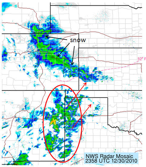
1.1″ snowfall at my house 5 N Dodge City as of 1:00am CST on December 31, 2010… making it the first inch of the season! Moderate to heavy snow began during the last hour of my shift at NWS Dodge City. On the official midnight observation, we measured 0.5″, which all fell during that last hour. On the drive home, moderate-heavy snow continued as the last band of heavy snow was positioned over Dodge City (Figure 1). We may get up to 2 inches, depending on how long this last band hangs around and/or redevelops back west a bit.
December 30, 2010
Central and Northern Plains New Years Eve Storm [post 5]
Wintry precipitation to impact much of Southwest Kansas, including Dodge City, tonight. This is a quick update on things on my blog while I’m at work in between updating official products here at WFO Dodge City. Radar shows precipitation blossoming across eastern New Mexico and West Texas (Figure 1) ahead of the developing upper low. The precipitation echoes on radar are not too bad considering the scant moisture across West Texas. The leading edge of the arctic airmass is making a fast run on Dodge City. Temperatures are crashing fast. It will be below 32°F here in Dodge City 8 or 9pm…with temperatures falling fast through the remainder of the night. Precipitation will begin as a mix of freezing rain and sleet… then becoming sleet and snow. The RUC and HRRR show as much as a quarter inch of total QPF close to Dodge City with heavier QPF amounts northwest of here. A winter weather advisory is in effect for much of Southwest Kansas (Figure 2).
Central & Northern Plains New Years Eve Storm [post 4]
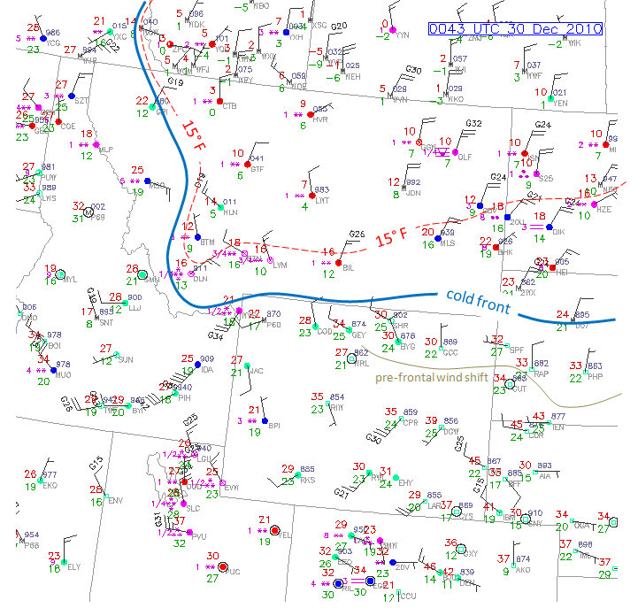
Interesting cold, convective precipitation in Dodge City tonight? The cold front is on it’s way (Figure 2)! A lead wave (water vapor in Figure 1) was lifting north across Nebraska late this morning which is providing portions of central/northern Nebraska with a priming coat of snow before the bigger storm (the ‘x’ over Arizona in Figure 1) impacts the region tonight into New Years Eve. It still looks like some substantial snow accumulations up in the area from northern Nebraska into the eastern Dakotas once the upper low deepens during the day Friday north of here (southwest Kansas).
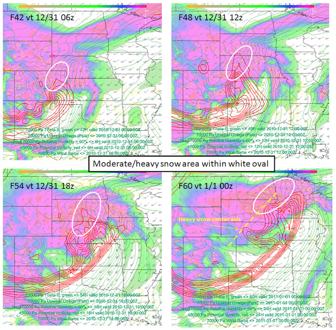
This post will focus on southwest Kansas… particularly here in Dodge City. I kind of look at this as a pre-brief for myself and what I have to look forward to on my evening shift tonight (4pm to midnight). The precipitation event for Dodge City will be tonight…particularly after about 8:00pm or so… and continuing until probably 3:00am or so? I took a look at the various high resolution model forecast composite reflectivity images (HRRR, 4km WRF NMM, 12km NAM) and the precipitation in Dodge City will be convective in nature (Figure 3) with some potential instability present at the nose of the mid level potential vorticity anomaly. The question will be how cold it will be. The arctic air is really not all that far away, and by the time the precipitation starts, the 30°F line will be precariously close to Dodge City (see bottom-right panel in Figure 3). The very leading edge of the arctic air will probably be shallow enough such that a warm layer aloft will exist and precipitation type may be either freezing rain or sleet… at least for a brief time…until we get far enough on the cold side of the arctic airmass. It’s really anybody’s guess as to how wide this corridor will be… but some convective sleet and freezing rain is certainly a distinct possibility tonight in and around Dodge City.
December 29, 2010
Central & Northern Plains New Years Eve Storm [post 3]
Bitter cold airmass is on the way. Winter Storm Warnings & Blizzard Warnings issued for portions of the High Plains, Northern & Central Plains. There isn’t a whole lot to update with this post. A bitterly cold airmass will envelop much of the Great Plains at the onset of snow across northeastern Colorado through Nebraska and into the Dakotas. In fact, temperatures Friday will hover around 0-5° F to go along with the moderate to heavy snow across portions of Nebraska and South Dakota. As if that wasn’t enough, north winds will range 20 to 30 mph with gusts frequently in the 35-40 mph range from western Nebraska through much of central and eastern South Dakota. This could turn out to be a nasty blizzard for a good portion of the northern Plains. As for closer to home in western Kansas, the bitter airmass will be the headline with afternoon temperatures in the single digits and teens. Accumulating snow will probably make it as far south as I-70, but unless the storm track makes an unanticipated shift to the south, much of Southwest Kansas will miss out on accumulating snow.
Figure 1 shows the surface map across the northern High Plains as of 6pm CST.
Figure 2 shows two NWS forecasts for the upcoming storm. The top is Hays, Kansas and the bottom is Valentine, NE. Notice the radical change in high temperature from Thursday to Friday at Hays!
Central Plains New Years Eve Winter Storm [post 2]
Another miss — Snow drought to continue in Southwest Kansas. It seems to be pretty clear now that the track of the storm is going to be such that Southwest Kansas will see the dry intrusion as cyclogenesis occur basically right over western Kansas… which is NOT where you want cyclogenesis to be occurring (over your head). At any rate, at least some portion of the High Plains will see some winter precipitation. I think if I had the opportunity to “snow chase” this system (which I don’t due to work), I would be on the fence with this one. A lead wave will push significant Gulf of Mexico moisture east, which will limit snowfall totals. Nevertheless, the forcing for ascent will be very good, and there will be an axis of heavy snow (6″ or greater). Strong winds creating a decent blowing/drifting snow event would have me interested. I kind of like Ogallala, NE right now as my virtual snow chase target (considering Dodge City as my starting point) with 6-9″ and 20-35 mph north winds. This would extend northeast to north-central Nebraska into southern and eastern South Dakota…and eventually up into Minnesota (again!!). See Figure 2 for details from the latest GFS model. Figure 1 shows a dProg/dT of the GFS over the last 4 runs of the 500mb forecast and SLP/Precipitation. The deterministic GFS appears to be locked into this solution taking the upper low from far southeast Colorado through Nebraska. This is similar to the Canadian GEM and the ECMWF.
December 28, 2010
Central Plains New Years Eve Winter Storm [post 1]
I have decided to begin blogging on the upcoming winter storm to affect the central plains since significant impacts look to include at least a portion of western Kansas. Western Kansas has had a dearth of precipitation this cold season, and this upcoming storm looks to be the best shot at widespread significant snow for at least some locations of the western plains that have not seen much at all this winter. To give you an idea how bad it’s been for western Kansas, the total snowfall for Dodge City through December 28th has been a whopping 0.2“! At Goodland, Kansas, 0.4” of snowfall has been recorded so far this winter. Now granted, The first half of the cold season is typically fairly scant with snowfall in western Kansas as compared to January-March, when most of the cold season average occurs, but still, this is certainly below average.
Now that we are within 72 hours of the event, the focus is becoming a bit more clear on potential impact. Snow and wind. Just exactly where these impacts will be depends on the track of the mid level cyclone. This appears to be a classic case of Rossby Wave downstream development as a Pacific trough centered just west of the dateline pumps a ridge around 145W longitude…and then subsequent trough development further downstream along the west coast of the U.S. All along the models have shown the ridging to be fairly broad over the Gulf of Alaska, which in turn would suggest a downstream mid-latitude cyclone development over the Rockies with the cyclone undergoing its most significant deepening as it exits the Rockies and enters western Kansas/Nebraska. Typically, this kind of track would not favor heavy snow for Southwest Kansas. If the ridge amplifies more than the GFS and ECMWF suggest, then the downstream equatorward transport of high-Potential Vorticity (PV) air would likely be driven farther south…and mid-level cyclogenesis occurring over New Mexico. Interestingly enough, the last couple runs of the GFS model have suggested a slightly deeper, southern solution. This would put more of western Kansas in play for potential heavy snow and wind.
I’ve attached two figures to this first post. Figure 1 shows water vapor loop from the evening of 28 December showing the source of the PV air that is the seed of the upcoming central Plains storm. Figure 2 is model output from the 18z run of the GFS model earlier today. I’ve annotated on both Figures some important features such as the jet core in white in Figure 1 and the PV air stream is also noted in both figures (along with what the ideal PV anomaly track is for heavy snow in Southwest Kansas). It should be noted that a shift in the PV anomaly of 70-120 miles farther south would put Dodge City on the southern edge of a nice snow and wind event. It’s obviously what I’m hoping for as a snow nut, but I’m not exactly anticipating it at this point. It will (hopefully) become much more clear tomorrow whether this will be yet another classic miss for Dodge City or if, in fact, we actually do see some nice accumulating snow for a change!

Figure 1

Figure 2


