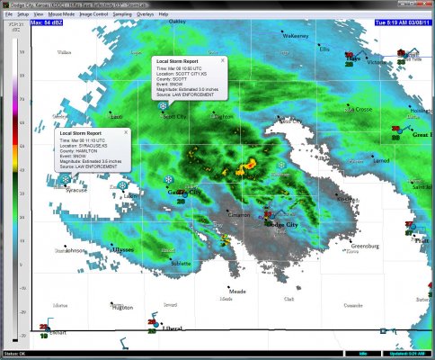
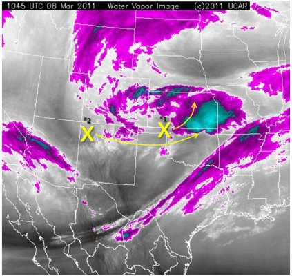
Sleet showers continued through the night. Warm advection centered around 850mb prevailed through the night, keeping the warm layer aloft in-check, and keeping the precipitation type sleet all through the night (after it had changed back over from the first snow band late last evening). As of the pre-dawn hours this morning, the highest snowfall totals were 3 to 4 inches from Syracuse to Scott City (see Figure 1 below). The initial potential vorticity (PV) max (‘x’ #1 in Figure 2) was lifting out into central Kansas as of 1100 UTC (5:00am CST), yielding subsidence now across southwest Kansas, including Dodge City (outside of a few widely scattered sleet showers along and south of the Arkansas River). The next mid level PV anomaly, anotated ‘x’ #2 i Figure 2, will move south of southwest Kansas later on today, providing another shot at light accumulating precipitation, which will most likely be in the form of snow with cold advection finally prevailing at around 850mb eroding the warm layer aloft.
and do not necessarily represent those of official National Weather Service forecast products,
therefore read and enjoy at your own risk and edification!"
March 8, 2011
Southwest Kansas Winter Storm 8 March 2011 [3]
Major FAIL?!?! Wow. Leave it to me to start blogging about a potential winter storm to bring the possible failure modes of this system to light. This is not looking good AT ALL. That first band of precipitation did produce 0.4″ of snow at my place, but has since ended as of about 10:45pm. The figure below explains the major failure mode with this system for Dodge City. I still think a few inches of snow are possible, but significant accumulations appear unlikely, and if it does occur, precipitation will need to reform again to the southwest of Dodge City.
Figure 1 (Illustrating/discussion potential major failure mode for a significant precip event for Dodge City):

Figure 2 (08/00z run of the GFS valid hours 6, 12, and 18):

NOTE: As I publish this post, precipitation is trying to form southwest of Dodge City back to the northwest of the major area highlighted in red in Figure 1. All is not lost…yet! Precipitation forecasting on the western plains is very sensitive to the little sub-synoptic scale nuances thanks to the “Rock Pile” just west of us.
March 7, 2011
Southwest Kansas Winter Storm 8 March 2011 [2]
Sleet has commenced at my house, 5 N Dodge City. The initial band of precipitation (see Figure 1) began to move in around 8:30pm. It has been pretty much all sleet up to this point through the time of this writing around 9:30pm. It’ll be interesting to see how long the precipitation type will be sleet. There is a disagreement with respect to the warmth of the warm layer aloft over Dodge between the RUC and the NAM. The RUC is about 1 to 1.5 degrees C warmer and keeps the zero line at 850mb quite a ways northwest of Dodge, whereas the NAM keeps the zero line quasi-steady right over Dodge (see Figure 2).
Southwest Kansas Winter Storm 8 March 2011 [1]
Significant, much needed precipitation event headed for southwest Kansas! For the better part of the last week or so, it appeared a major winter storm would affect the western Plains. Mid to late last week, all of the global spectral model solutions (and to a large degree their associated ensemble members) were focusing on western/central Nebraska…into southern South Dakota for this storm. By Friday and Saturday (March 4-5), the models were beginning to suggest a more southern track to the storm. It then became apparent that northwest Kansas into south-central South Dakota would see the brunt of the storm. Now that the storm is now within striking distance, all models are locked in on a solution with the mid level PV anomaly and evolution, and it really does favor Southwest Kansas for substantial precipitation. While the placement in the models was always in question, what was a near-constant was precipitation potential with the storm. 36-hr storm total precipitation from the GFS as well as the Canadian GEM consistently showed potential for 1.0 to 1.5″ of storm total precipitation within the “sweet spot”. Late last night and early this morning’s model runs showed this 1.0 to 1.5″ storm total QPF shifting south to generally a Lakin-Dighton-Wakeeney line… continuing northeast to north-central Kansas and southeast Nebraska. 18z runs of both the GFS and the NAM have continued this southward shift of the 1.0 to 1.5″ axis even further… to roughly a Ulysses to Garden City to Jetmore corridor. Both the 07/18z NAM and the GFS show 1.0″+ storm total QPF for Dodge City. It stands to reason now that Dodge City will be included, if not VERY close, to the sweet spot of the storm.
Now precipitation type. Today, a shallow arctic cold wedge was moving south and was more aggressive in its movement south than any of the models from last night were suggesting. This isn’t a surprise (early last week’s arctic cold wedge event in southwest Kansas is a classic example). As I type, the temperature in Dodge City 33 degrees (See Figure 1), and advection on north winds 15-20 mph will continue to lower the temperature through the evening into the upper 20s.
Precipitation in Dodge City will likely commence as some light freezing drizzle later on this evening with more widespread precipitation in the form of freezing rain/sleet sometime around midnight or thereafter. Huge questions regarding how shallow the cold wedge will be in Dodge City and whether it will be deep enough for the warm layer aloft to be pinched off enough to support all snow (entire sounding below zero Celsius). I think we will see several hours of accumulating sleet overnight with a change over to snow probably 4-7am or so tomorrow morning. I took a look at the 12-hour QPF from the 18z run of the GFS ending 09/00z and it showed about a half inch of QPF during this time frame… this would suggest as much as 4-6″ snowfall after the sleet/freezing rain. Below are some figures I put together
Figure set 2 (18z NAM model depiction of 700mb RH/Omega, 850mb Temperature):
Figure set 3 (18z NAM model depiction of 400mb Potential Vorticity/Wind Speed, 500mb Heights):


