Mon, 30 May 2011 13:47:02 -0500
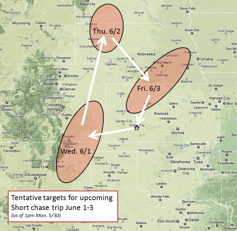
Tentative storm chasing plans June 1-3 | | After my last midnight shift early Wednesday morning (June 1), I am
free to roam the western and central plains until I am due back to
work Saturday morning (June 4), and the overall pattern is favorable
for storms to chase each day. Moisture will return to the high plains
late Tuesday and early Wednesday. I have really liked the looks of
northeastern New Mexico east of the Sangres (Las Vegas, NM northeast
to Clayton) for several days now. After that, though, eastern New
Mexico will likely dry back up from a severe storms standpoint and I
will have to shift my attention back to the north. The threat area
Wednesday may include east-central CO and far western KS. The
300-500mb jet core will overspread the central Rockies and northern
High Plains Thursday -- and on paper this looks to be the best day of
the three of this short trip. I am tentatively thinking about the
northwestern Nebraska area near the South Dakota border east/southeast
of the Black Hills, but I may end up heading all the way up into
central/northern South Dakota where even higher CAPE will exist > 4000
J/kg more than likely with 45-50 knots 500mb flow out of the
southwest. Thursday could be a very good day for the Dakotas. The
front then moves south late Thursday Night and Friday pushing the
focus for storms back into the central Plains. By late day Friday,
the front will probably be positioned across southern Nebraska or even
farther south toward Northwest/north-central Kansas... which is good
as this would be a shorter drive back to Dodge to conclude this trip.
More later.
|  |
|