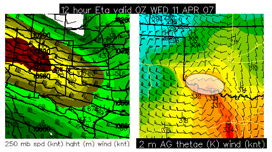
Another marginal day, but… There is the potential for a nice little surprise along the Red River over far Southwest Oklahoma. I will be chasing today because it is my only day off this week and I will not be able to chase Thursday (which looks quite a bit more promising), so I need to make hay while the sun shines! I will be targetting the area shown below in the graphic late this afternoon/evening — a favored region at the nose of a strong upper level jet where surface cyclogenesis will be maximized. The NAM and RUC show increased moisture over this area… a little more moisture than previous models runs of the NAM were suggesting, thus CAPE will probably reach 1000 J/kg over this area as well. I’ll be departing Dodge City around 11:00am (in about 50 minutes). For those "virtual chasing" with me today, I’m not sure how good the cellular coverage will be in Southwest Oklahoma… I know that en-route through Northwest OK I will have essentially no data signal at all, so you probably will not see updates until early afternoon when I get south of I-40.