|
status:
|
>> August 2022 -- North American Monsoon Lightning -- Southeast Arizona Region
(Updated November 15, 2024 4:15:52 pm CT)
|
-- No recent radar/chase position image. --
Mike has not been in active CHASE MODE in the past 48 hours!
....map loading, please wait...
....map loading, please wait...
|
== Latest photos and blog posts from Storm Chase Trip 2012 (June 23-July 1) ==
>> Next Page Wed, 13 Jun 2012 14:36:52 -0500
Beginning of the late June chase trip within range of numerical prediction scrutiny! | Today is Wednesday, June 13th -- still a solid 10 days away from Day One
of my annual storm chase trip -- and the time has come to begin
speculating on how the beginning of the trip will look as far as storm
chasing/photography prospects go. I will be chasing with Evan
Bookbinder and Jay Antle... leaving Kansas City either late night Friday
Night the 22nd or first thing in the morning on the 23rd. Attached to
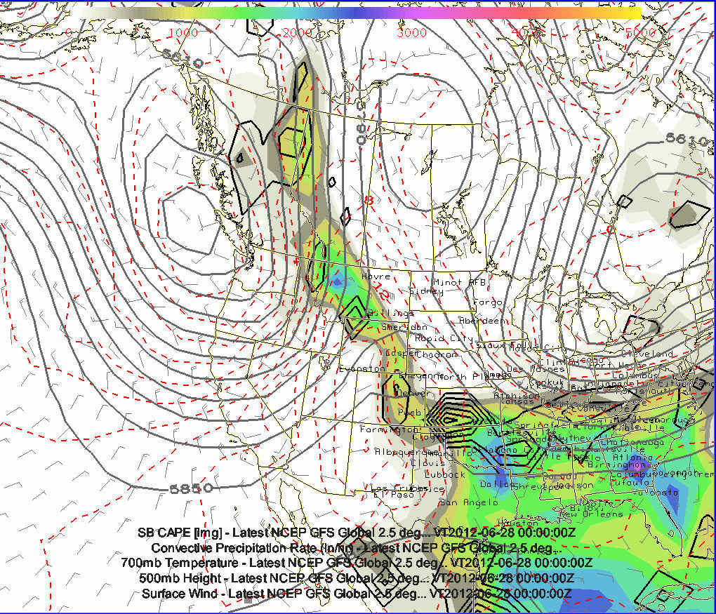
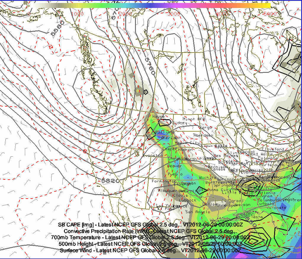
this post are 6 images showing this morning's 12z run of the GFS valid
June 23rd through June 28th. The GFS is hinting at a very well-defined
trough off the coast of Washington-British Columbia... bring multiple
days of southwest flow across Montana and into Alberta and southern
Saskatchewan.
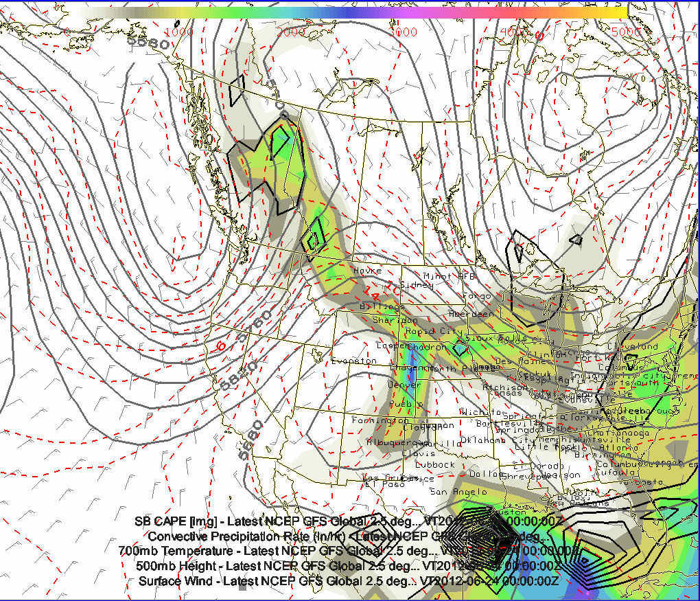
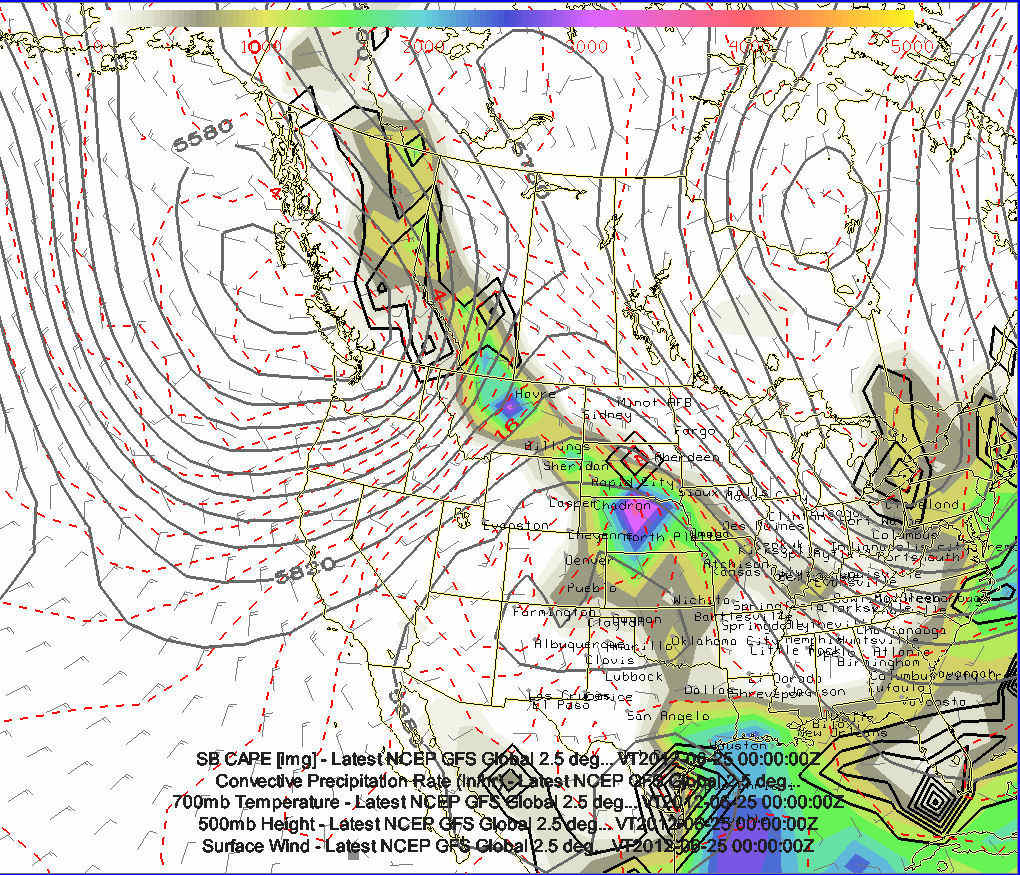
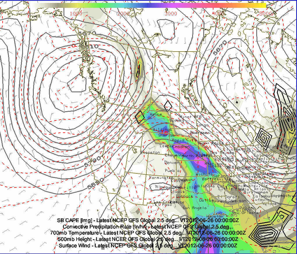
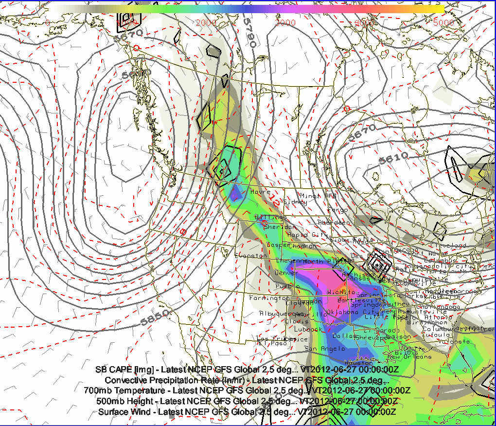
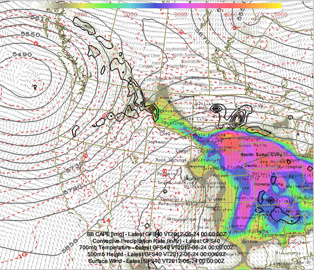
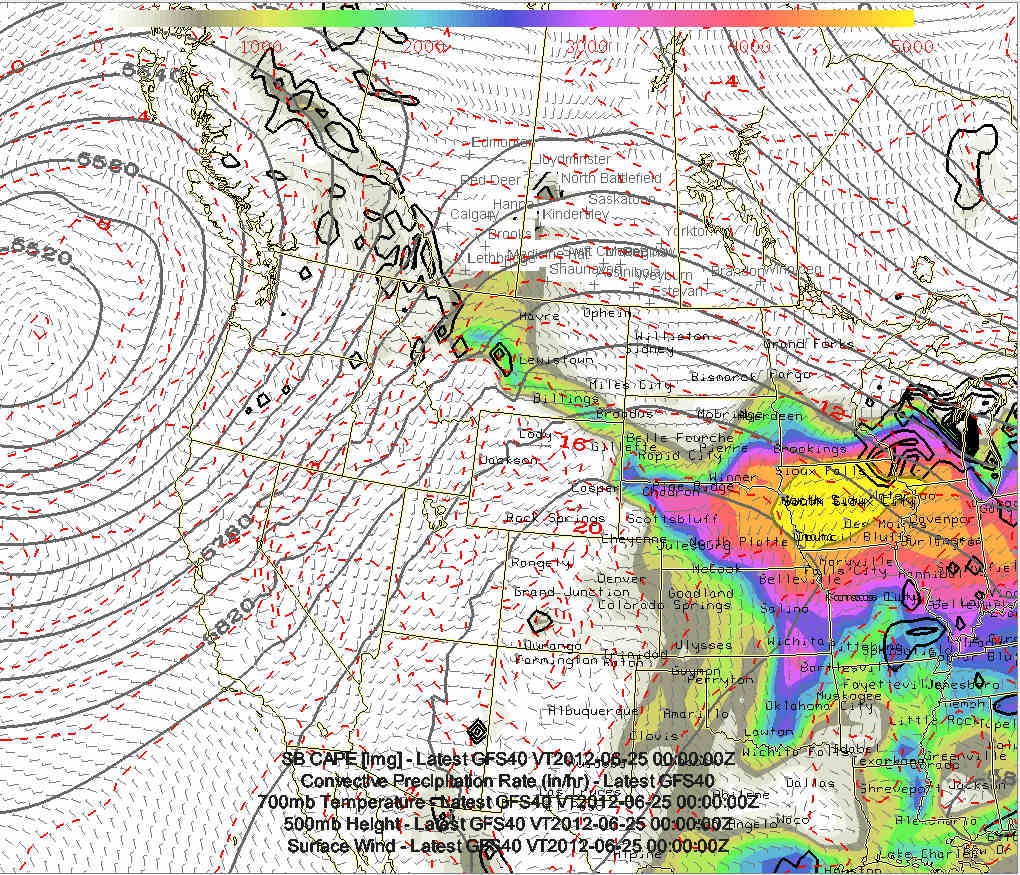
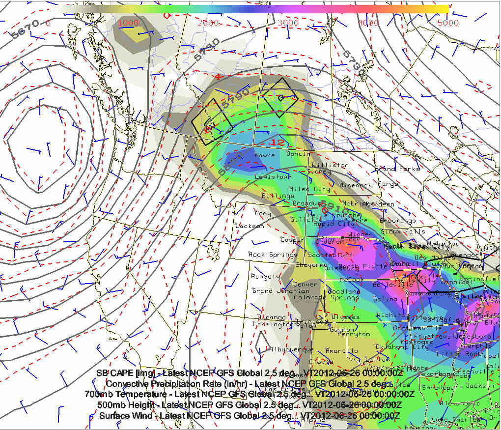
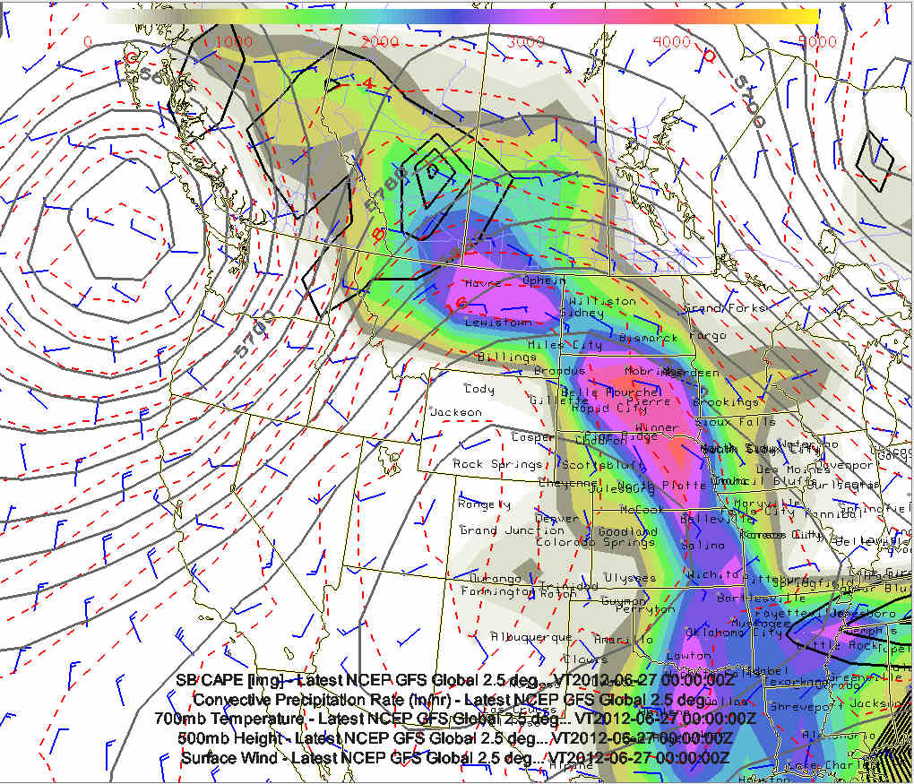
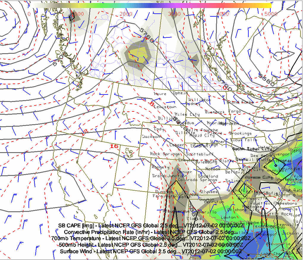
The images are of the GFS 500mb Heights, CAPE, Surface Wind, and QPF
valid 00z June 24th (Image 1) through 00z June 29th (Image 6)
This would be a dream setup if it were to pan out this way... but this
is the 240-368 hours out and models have next to no skill at synoptic
features. However, the good global models to have just a little bit of
skill in the longwave pattern... and the continued notion of low heights
in the Pacific Northwest/northeast Pacific Ocean with an extended
Pacific Jet is probably a noteworthy signal in the models June 23-June
26th time frame.
| (click on thumbnails for pop-up of larger images) |
Thu, 21 Jun 2012 04:11:31 -0500
Latest chase forecast thinking for June 23 (Day 1) through June 27 (Day 5) |
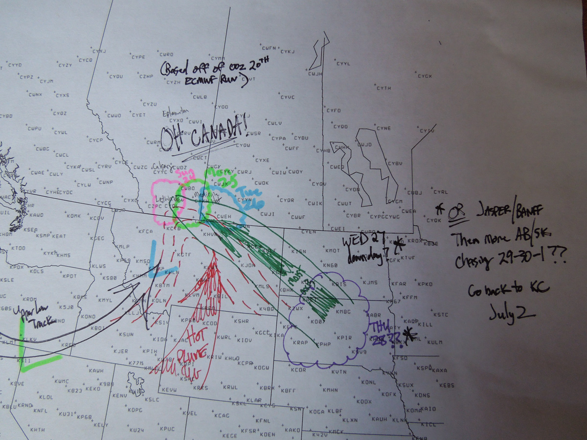
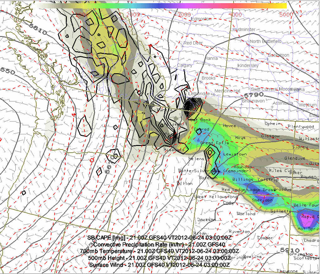
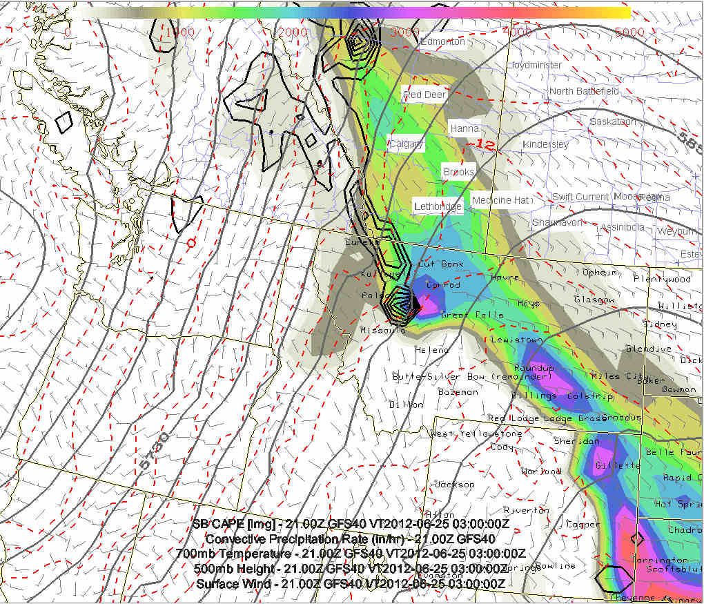
Day One (Sat, June 23): (GFS Composite Chart, See Fig. #1)
The BIG drive day. After a hopefully incredible night in the dugout
suites at the Royals vs. Cardinals baseball game in KC, Evan
Bookbinder and I will begin the big drive with an estimated time of
departure around midnight. I am fresh of my midnight shifts, so I
will be pulling the majority of the overnight driving. We plan to
make the 20-hour, nearly non-stop drive to Great Falls, MT with an
estimated time of arrival around 7:30 or 8pm MDT (0130-0200 UTC).
If we do indeed make it there by that time, we will still have
around two hours of photographic daylight to work with for any
storms that may be ongoing in the Great Falls-Conrad, MT vicinity.
If we do indeed manage to photograph a storm on Day One, it will be
quite the incredible feat after starting in Kansas City the night
before. Day One is largely a positioning day to get ready for what
looks to be a fairly impressive stretch of storms from far northern
Montana into southern Canada
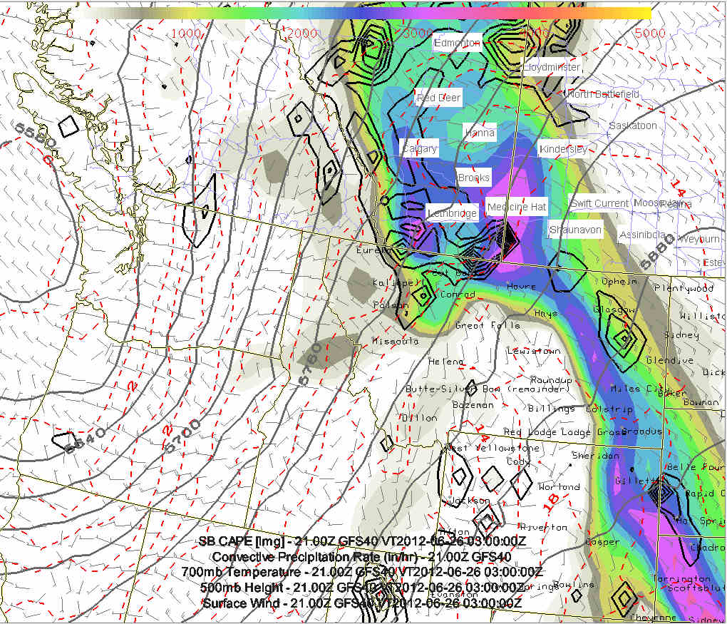
Day Two (Sun, June 24): (GFS Composite Chart, See Fig. #2)
We will likely begin this day in Great Falls, MT or something like
that. Day Two looks like the same area as Day One, so the driving
may be kept to a minimum... which would be good! The main upper low
will still be sitting off the coast of Oregon-Washington with
south-southwest mid level flow over the Montana and Alberta
Rockies. Good dewpoint air in the upper 50s to lower 60s will yield
1800-2200 J/kg CAPE with both the GFS and ECMWF suggesting supercell
storms from west of Great Falls off the mountains northward to west
of Lethbridge, AB.
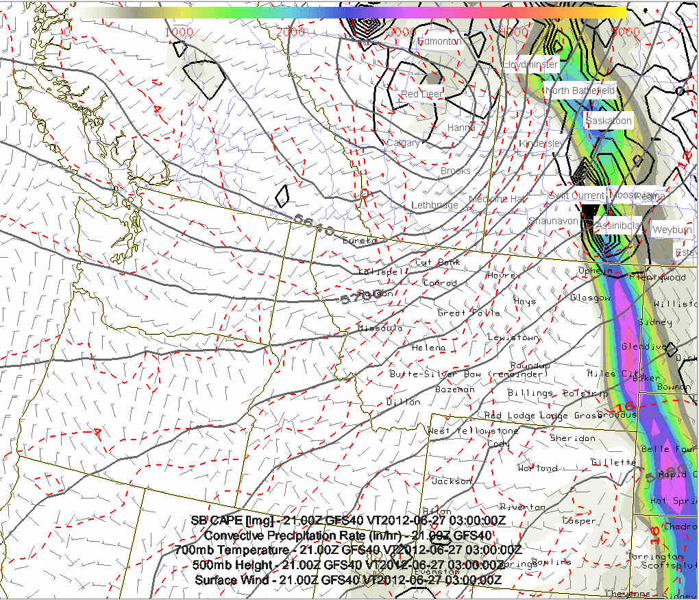
Day Three (Mon, June 25): (GFS Composite Chart, See Fig. #3)
More storms are expected in the same general vicinity as the
mentioned upper low inches very slowly toward the Oregon-Washington
coast. The GFS model suggests even higher moisture and CAPE
spreading northward into Alberta. This may be the first day to
chase in Canada from Lethbridge to Medicine Hat.
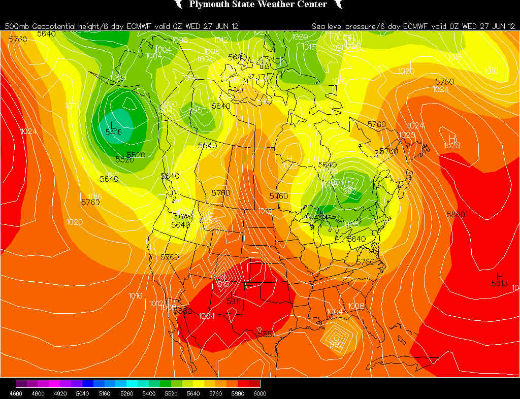
Day Four (Tue, June 26): (GFS Composite Chart, See Fig. #4,
ECMWF 500mb/MSLP Chart, see Fig #5)
This is where the GFS and ECMWF models really begin to diverge in
how fast it ejects the upper low northeastward. The GFS is much
faster than the ECMWF model... and in fact the ECMWF model has
slowed down even more than the previous runs. Where the GFS
suggests the best play will be well into southeastern Saskatchewan
(east of Swift Current to Assiniboia, SK), the ECMWF suggests yet
another day (perhaps the best day of the bunch) back in southeastern
Alberta from Lethbridge to Medicine Hat. This is still quite a ways
away, but the trend of slower is certainly promising for additional
chasing without a substantial amount of driving.
Day Five (Wed, June 27):
The GFS model, given its faster speed, is suggesting a down day
Wednesday, but the slower ECMWF would suggest yet another chase day
farther east in Canada from southeastern Saskatchewan to
southwestern Manitoba.
| (click on thumbnails for pop-up of larger images) |
Sun, 17 Jun 2012 15:24:53 -0500
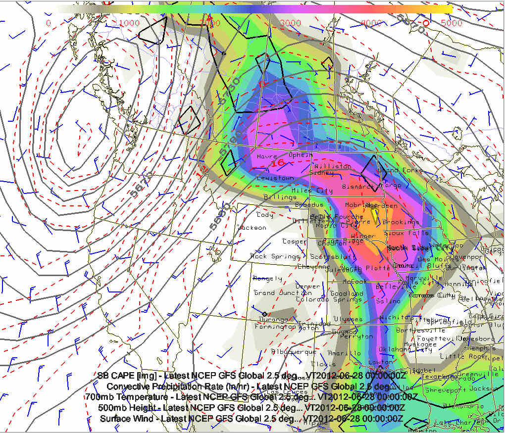
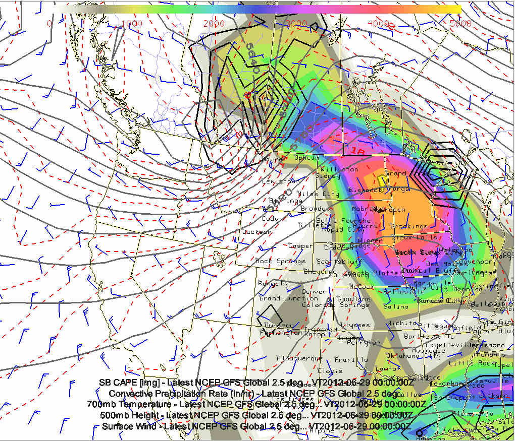
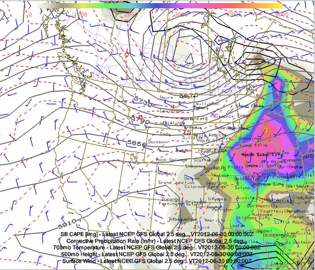
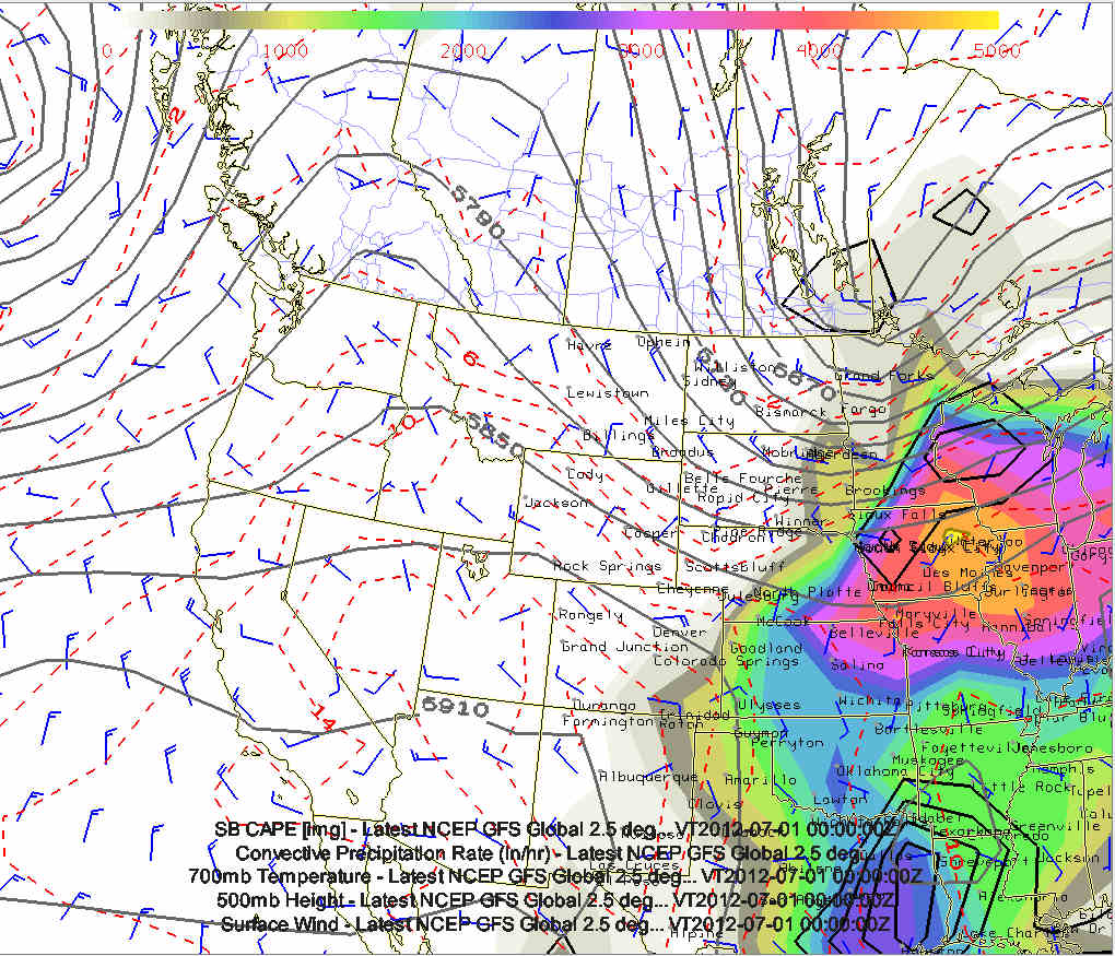
GFS model charts from the 12z Sunday 6/17 run | Composite chart of 500mb heights, CAPE, 700mb temperature, and QPF:
#1 valid 7pm CDT, Saturday 6/23
#2 valid 7pm CDT, Sunday 6/24
#3 valid 7pm CDT, Monday 6/25
#4 valid 7pm CDT, Tuesday 6/26
#5 valid 7pm CDT, Wednesday 6/27
#6 valid 7pm CDT, Thursday 6/28
#7 valid 7pm CDT, Friday 6/29
#8 valid 7pm CDT, Saturday 6/30
#9 valid 7pm CDT, Sunday 7/1
Impressive, large scale upper low off the coast of Washington/British
Columbia may yield plentiful chase opportunities in Montana...and
eventually North Dakota... perhaps a day or two in southern
Alberta/Saskatchewan! A lot can still change in the models, and
probably will, so it's still quite a bit of speculation at this point.
| (click on thumbnails for pop-up of larger images) |
Sat, 23 Jun 2012 06:31:03 -0500
Chase Trip Day One, June 23 Target: Harlowton to Great Falls, MT | The time is almost 6:30am and we are less than an hour from North
Platte, NE after driving all night. Well, Evan has been doing all the
driving so far, but I'm about to take over so he can get some sleep.
We are still planning on continuing the drive as far northwest as we
have daylight, as the best area for severe storms/supercells will be
up in the Great Falls area. The NSSL WRF model shows a nice supercell
signal around or just north of Great Falls from 00-03z. At our
current pace, we can reach Great Falls by 01z... which is 7:00pm
mountain time. Sunset in Great Falls is about 9:30pm MDT (0330z). So
that's the plan as of right now... another update later on today.
|
Sat, 23 Jun 2012 13:17:17 -0500
1 PM Update: Onward Through Wyoming | 13 hours
into the epic drive from Kansas City to Great Falls, Montana has landed
us in Casper, WY for the moment as of noon MDT. Incredibly hot airmass
has pushed well into the interior with a noon reading of 95 degrees in
Casper, and highs of 110F are possible over western Kansas today. Wow!
Our thought process hasn't changed since early this morning with a plume
of quality moisture (characterized by mid-upper 50F dewpoints) funneling
westward through Montana, beneath steep lapse rates and strengthening
mid-upper flow. Powerful trough that will bring us a string of opportune
days remains off the Oregon coast per early afternoon water vapor
imagery. Forecast soundings and shear profiles still look fantastic for
rotating storms across western Montana early this evening as the
increasing moisture/daytime heating couples with strong, veering flow
with height. Really the only lingering concern is with the placement of
synoptic scale lift. The HRRR/RAP hold the lead wave further west,
yielding an arc of supercells along the MT/ID border across the higher
terrain. Without a 120 mph speed limit, this is simply unreachable, so
we remain hopeful of additional evening development 00-03Z toward GTF.
Already one dust devil across the rolling hills and Cu development over
the higher terrain to the north. Stay tuned! -
Bookie |
Sat, 23 Jun 2012 20:22:28 -0500
7:15 PM MDT Chase Update - Target Storm | Things are changing quickly as the lead shortwave impulse has come across
the higher terrain of Montana in concert with peak heating, the return of
abundant low level moisture (55-60F dewpoints) and strong vertical shear.
Visually, one very impressive/isolated cell has developed a very crisp,
back-sheared anvil northwest of Great Falls. This storm is about 100 miles
NW of our current location, and a right moving supercell should afford a
slow eastward turn. With its slow movement we hope to be in place to
intercept before 9 PM. (This leaves us a good 2 hours of daylight). This
storm is quite impressive on radar for so early in its life cycle as well,
and appears well underway to acquiring supercell structure if not already.
Very excited! - Bookbinder
| 
(click on thumbnail for pop-up of larger image) |
Sun, 24 Jun 2012 23:23:03 -0500
chase update 1105pm cdt. Driving back to Great Falls after an awesome day at Glacier NP. Back to storm chasing tomorrow we hope! | When we get back to the hotel in Great Falls, I will upload a few
images from today at Glacier NP, including a bizarre scene that
unfolded right in front of us along the Going to the Sun Road at
Glacier NP. There was quite a bit of snow along the road in many
places through the heart of Glacier NP where elevation rose above
6,000 feet near the Logan Pass. There was a remnant pillar of snow
right adjacent the rock face, probably up to 20 feet tall, which had a
temporary "unstable snow" sign that the park rangers put there next to
it.. as they knew that it was probably about to fall. Well, sure
enough it did... and we were there to hear it. Evan and I both have
before and after pictures of this moment. In fact, I have a picture
of Evan standing next to the sign before it fell (but not in the
direct line of the pillar of snow should it finally collapse). When
it fell, it fell directly onto the road, effectively blocking it. As
more cars approached the scene, people got out to help move big chunks
of the old snow and ice until a 4x4 vehicle was able to start a path
through to open a lane up to get through. The waterfalls all through
the park were awesome from all the snow melt that was going on. There
was one instance along the road where multiple water falls were
crashing down right on the edge of the road which provided some of the
most unusual scenes I've ever seen. All in all, this was one heck of
a fun trip through Glacier NP!!
Tomorrow, June 25 (Day Three) looks to be a chase day, but the
potential target is fairly broad at this point from southwestern
Saskatchewan down into northern Montana. More details on that
tomorrow morning.
|
Mon, 25 Jun 2012 10:50:29 -0500
Chase Trip Day 3 Target Medicine Hat to Kindersley, SK | Evan Bookbinder and I will be departing Great Falls by 1030am or so and
heading into Canada. 700mb temperature zone of +10 to +12C will be up in ca
nada, so that's our target. We should be up in the target area by aroun
d 4pm mdt. High instability with cape approaching 4000 j/kg as far north
as northeast of medicine hat
|
Mon, 25 Jun 2012 15:07:09 -0500
6/25 2 PM MDT Chase Update - Canadian Bound | | After a 30 minute chit chat with the Wilson Creek, SK border officers about
the ins and outs of photography, we finally did it! CANADA!!! First time f
or the both of us and we are very excited. We are headed to Maple Creek (ar
rival time about 3:30 PM) for analysis and targeting.A northwest moving
gravity wave (possibly generated by an early moning supercell), has ignited
an arc of elevated convection along the SK/AB border between Cavedish and
Kindersley, and the models actually had this early activity. The real show
should commence much later this afterno/evening as a strong shortwave troug
h lifts from Idaho across theCanadian border. High temperatures in the l
ow to perhaps mid 80s (sorry, we are staying with US units) and unseasonabl
y moist dewpoints in the mid 60s should yield a very unstable airmass with
3000-3500 J/kg of MLCAPE. Strong convergence along the western edge of the
low level easterlies, coupled with mid level height falls and increasingly
favorable shear profiles should yield an environment primed for scattered s
upercells along the NW edge of the cap. Activity may initiate in SE AB or S
W SK, with a northeast storm motion. We should have ample daylight to 11 PM
. More to come later. BOOKBINDER/UMSCHEID
|
Mon, 25 Jun 2012 19:48:42 -0500
CHASE UPDATE 6:45 PM MDT | | We crossed the Sask./Alberta border on Trans. CanadaHighway 1 and notice
d the winds had shifted from east to southwest, indicating a sfc low had de
veloped off to our north. Based on this,and the look of the cloud field,
we took Highway 41 north out of Medicine Hat, AB and watced Cu become tower
s and then several huge Cb in a matter of minutes. Currently racing toward
Oyen to intercept what, from the distance, looks to be a raging supercell.
Current temp 86F with a dewpoint of 67F. Pretty amazing for the interior of
eastern Alberta. With the lead wave aloft just now coming in from the sout
hwest, we are very hopefully about this intercept in the next 45 minutes. B
OOKBINDER
|
Tue, 26 Jun 2012 09:20:51 -0500
Chase Trip Day 4 Target (June 26): Swift Current, SK early afternoon storms.. then as far east as Weyburn, SK early this evening. Big day, tornadoes likely in southern Saskatchewan | The time is 8:15am MDT, and Evan and I are currently in Kindersley, SK.
At this time, there are already elevated supercells crossing the
US-Canada border northwest of Havre, MT. This trend will continue
through the late morning and into the early afternoon, so we need to get
moving here in a bit and head southeast to Swift Current to catch any
early afternoon supercells which could quickly become surface based.
Tornadoes could occur as early as 1:00pm MDT today as a very impressive
upper low lifts northeast into northwest Montana later today.
Outlook:
After today's chase, we will likely stay for the night somewhere just
north of the US-Canada border then make the trip back south into the
states Wednesday. Wednesday looks like a down day, but the
Thursday-Saturday time frame (June 28-30) looks pretty good from
northern Nebraska into central South Dakota for repeated supercell
possibilities in a zonal flow pattern with high instability/moisture in
place.
|
Wed, 27 Jun 2012 19:24:46 -0500
Chase Trip Outlook through end of trip (last possible chase day July 2) |
Right Now, Wednesday evening June 27 (Day 5):
Wednesday evening we are driving to our motel for the night in Belle
Fourche, SD. Evan and I should be there around 8pm MDT or so. The
sky has quite a milky appearance here in the western Dakotas with
smoke obviously in the air from fires way out west/southwest.
Tomorrow, Thursday June 28 (Day 6):
The NAM shows pretty good moisture/instability on post-frontal
easterly winds into western Nebraska. After a visit in the Badlands
east of the Black Hills in the morning, we will set our sights on
the Nebraska Panhandle somewhere, it would appear right now. I like
the aggressive QPF signal in the NAM model. There will be enough
westerly flow in the mid/upper levels (50 knots at 300mb as far
south as Alliance, NE), so organized severe storms appear likely.
It could be tough chasing as storms move into the desolate
Sandhills, but photography can be quite good. Status: Chase Day
Friday June 29 (Day 7):
The mid/upper flow still looks pretty good from almost the due west
across northern Nebraska/southern South Dakota. Low level
convergence will be maximized somewhere from central South Dakota
into north-central Nebraska. This also looks like a pretty decent
chance at chaseable severe storms given the forecast CAPE and wind
shear combination. Status: Chase Day
Saturday June 30 (Day 8)
The GFS shows a minor wave moving southeast around the periphery of
the central U.S. ridge into eastern North Dakota/Minnesota. This
will bring a weak front south into central South Dakota by evening
with a favored area for chaseable storms perhaps around the
Mobridge, SD area. The band of 50-70 knots at 300mb will be shifted
northward into northeastern SD and eastern ND, so it would appear we
will be farther north on Saturday. Meanwhile, a ridge will be
building over the high plains as a new trough forms along the
Pacific Northwest coast. Status: Chase Day
Sunday July 1 (Day 9)
The Pacific Northwest trough will move inland and the focus will
shift back west into Montana. So, as if right now, it looks like we
will potentially have one more Montana chase day as moisture is
pulled back northwest into this region as pressures fall in Montana
in advance of this shortwave trough. Status: Chase Day
Monday July 2 (Day 10, last day)
The last chase day looks to be a decent one, potentially, if the GFS
is right as Pacific jet stream energy enters the northern Dakotas
and interacts with abundant moisture with very high CAPE likely and
southwest mid/upper winds providing excellent shear. If we do
indeed chase in North Dakota this day, we will need to pull another
all-nighter drive back to Kansas City, as I need to be back sometime
early afternoon July 3. Status: Chase Day
|
Thu, 28 Jun 2012 12:45:33 -0500
June 28 Chase Update | After an excellent morning in Belle Fourche, SD, Mike and I are headed
into the Badlands region in search of landscape photography and
hopefully some wild bison (and other native wildlife). We will then head
south toward the Nebraska sandhills to meet back up with Jay and chase
some high-based severe convection. Models continue to focus a
post-frontal ribbon of moisture across western Nebraska with a nice
pocket of instability as temperatures warm into the lower 90s. Storms
should fire along the convergence driven by modest post-frontal upslope
flow across NW Nebraska. With very deep mixing to possibly 600mb,
coupled with decent cloud-bearing shear profiles, we are hopeful for
some nice storm structure across the barren sandhills region early this
evening. - Bookbinder
|
Fri, 29 Jun 2012 01:21:03 -0500
Chase Trip Day 6 (June 28) Recap and chase plan June 29-July 2 | Evan and I began the day in Belle Fourche, SD where we set off for the
Badlands to drive around and sightsee (Evan has never seen the
Badlands). After that, we drove down Allen Rd... a 28-mile unpaved road
south of the Badlands eventually stopping at Martin, SD. There, we
pretty much resigned our fate to a busted chase... that is until we
pulled up visible satellite image and noticed towering cumulus
developing about 100 miles to our south. We plotted a course to
intercept this area of congested cumulus... which eventually turned into
a storm, albeit rather small. We intercepted the storm around 7pm CDT
just south of Thedford, but all that was left by the time we got there
was a shriveled up updraft base. This eventually croaked completely and
we then headed north back to South Dakota. Along the way, we
photographed a beautiful red sunset over the sandhills and one of the
large ponds (around Valentine Nat'l Wildlife Refuge). along US-83. As I
type at 115am, we are coming into Rapid City and are staying in Belle
Fourche. We are hooking back up with Jay Antle at a motel he already
reserved at Belle.
Tomorrow, Fri 6/29 looks pretty good up in the Baker, MT to Bowman, ND
area... and will probably settle in to Belle Fourche again after
tomorrow night's chase... as Saturday looks pretty decent for chaseable
storms southeast of the Badlands (somewhere across central/southern
South Dakota). On Sunday, July 1, the focus turns back to
northern/northeastern Montana. Monday, July 2, the last potential chase
day, still looks to be perhaps the best day of the last half of the trip
somewhere in North Dakota.
|
Sat, 30 Jun 2012 17:28:07 -0500
Fwd: 4:30 PM CDT Jun 30 Chase Update | Had an awesome early afternoon at a park in Spearfish, SD and have made
our way down east of Rapid City. After watching a nice storm go up over
the Black Hills, we have decided not to go after it since it appeared to
be rooted in the terrain and driven by orographics and very weak shear.
Meanwhile, hi-res radar imagery shows strong cyclonic flow just east of
RAP with a number of feeder convective rolls spiraling in toward areas
just east of the city. The Cu field continues to grow with several areas
of strongly agitated Cu east and northeast of Rapid City. The deep layer
shear is also much improved with eastern and northern extent. Unlike
yesterday, the upper winds are from the northwest, which may lead to
storms struggling to maintain buoyancy as their anvil shadow is cast
downstream along the expected storm motion. Additionally, storm spacing
may be an issue with the entire axis of instability primed to go, so
mergers and outflow dominance may take over with time. Still hoping we
can maintain some discrete nature for a while, and that scenario looks
quite promising given the initial low level flow fields. Should be a fun
show regardless with maybe our first evening lightning photography
attempt afterwards. - Bookbinder
|
Sun, 01 Jul 2012 11:29:27 -0500
Jul 1 10:30 AM MDT Chase Update | As we turned the page to July, we finished night 4 in Belle Fourche and
were greeted by some sort of Miss South Dakota audition in the hotel
this morning. Sorry to have to leave! The forecast for today will take
us to northeast Montana as another large trough deepens off the NW
Pacific coast, sending several disturbances across this region. In the
wake of a remnant sfc trough over the eastern Dakotas, morning sfc data
shows a nice fetch of ESE winds across ern MT into the wrn Dakotas, with
favorable upper 50-low 60s dewpoints returning westward along a
developing warm front. This will occur beneath an increasing fetch of
strengthening SW flow aloft, yielding a nice combination of moderate
instability and favorable deep layer shear for a few supercells across
the eastern MT prairies late this afternoon and evening. Will stage near
Circle, MT this afternoon.
|
>> Next Page
|