| About This Shoot | Date: 26 April 2011 | Location: Northern Texas Panhandle from Miami to Perryton | Shoot Type: Storm Chase | Rating: | Synopsis:
Intercepted and photographed two hail storms. The first storm moved east-southeast across Roberts County to the north of Miami and through Canadian before weakening. The next storm intercepted was farther northwest near Perryton and revealed more impressive, multi-tiered shelf cloud structure on its leading edge. A few vivid cloud-to-ground lightning flashes were captured as well. |
|
Other Shoots Around This Date 16 Apr | 17 Apr | 18 Apr | 19 Apr | 20 Apr | 
21 Apr | 22 Apr | 23 Apr | 24 Apr | 25 Apr |
26 Apr | 27 Apr | 28 Apr | 29 Apr | 30 Apr | 1 May | 2 May | 3 May | 4 May | 5 May | 6 May | |
|
Navigate Other Shoots (by year) Navigate Other Shoots (by month)
|
Preliminary Storm Reports from 26 April 2011
 |
1630 UTC SPC Products from 26 April 2011

Categorical Convective Outlook
|

Probabilistic Tornado Outlook
|

Probabilistic Hail Outlook
|

Probabilistic Wind Outlook
|
|
Evening Meteorological Charts from 26 April 2011

250mb Chart
|

500mb Chart
|

700mb Chart
|

850mb Chart
|

Surface Chart
|
|
|
Mon, 16 May 2011 10:23:31 -0500
26 April 2011 Chase Summary & Images -- Northern Texas Panhandle (Part 1)
Summary & Images (part 1) | This was a solo chase while I was on my 10pm to 6am shifts. I knew
this was going to be an early show as far as storm initiation was
concerned, and given the chase target was a little more than two hours
from Dodge City, I decided to make a go of it. Very cool temperatures
aloft and marginal moisture of 45 degree dewpoints would yield about
800 to 1200 J/kg SBCAPE. I targeted the area around Spearman, TX.
The first storm I intercepted was one which formed to my southwest
between Stinnett and Spearman. Unfortunately, this storm was moving
east-northeast through the desolate ranch land of eastern Hutchinson
and Roberts County. I had to drive all the way east to Hwy 70 before
heading south for an intercept. I waited on the storm in northern
Roberts County near the Canadian River. I then followed the storm
southeast along Hwy 283. The sequence of images shown here are of the
storm during this portion of the chase through Roberts County:
| (click on thumbnails for pop-up of larger images) |
Mon, 16 May 2011 10:52:08 -0500
26 April 2011 Chase Summary & Images -- Northern Texas Panhandle (Part 2)
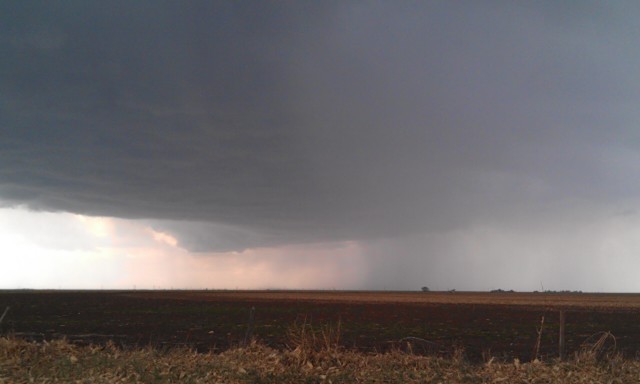
Summary & Images (part 2) | *Perryton Storm*
After the first storm dissipated and moved east near Canadian, I decided to
intercept another fairly strong storm that was approaching Perryton from the
Oklahoma Panhandle. This storm was moving east-southeast and would be a
good intercept on the way back home to Dodge City. This was a nice little
surprise and ended up resulting in my best images of this chase. The shelf
cloud associated with this storm was rather photogenic as I approached it
over northeastern Ochiltree County southeast of Perryton. I followed it
south then back to the east along some county roads, stopping every few
miles along the way to photograph.
| (click on thumbnails for pop-up of larger images) |
Mon, 16 May 2011 11:00:58 -0500
26 April 2011 Chase Summary & Images -- Northern Texas Panhandle (Part 3)
Summary & Images (part 3) | Cloud to ground lightning east of Perryton
Shortly after photographing the structure of the Perryton storm's shelf
cloud, I continued east on a county road about 8 miles south-southwest of
Booker, where I stopped to photograph some of the fairly vivid
cloud-to-ground lightning. As the storm approached, I booked it east to
Road 1265 where the core of the storm overtook me and I received copious
amounts of pea to penny size hail which covered the road about 6 miles south
of Booker. After this was over, I made my way back to Dodge City.
| 
#1 | 
#2 |
(click on thumbnails for pop-up of larger images) |
Tue, 26 Apr 2011 18:46:56 -0500
Storm chase update 635 pm | Heading back toward dodge buy on the way more linear storms hearing towards Booker and perryton that I might b able to photograph
|
Tue, 26 Apr 2011 18:45:40 -0500
Storm chase update 635 pm | Heading back toward dodge buy on the way more linear storms hearing towards Booker and perryton that I might b able to photograph
|
Tue, 26 Apr 2011 15:52:13 -0500
storm to my west at 348 pm | I am on highway 70 between perryton and pampa looking west.. this storm is moving slower than I thought so I will have to wait for it
| 
(click on thumbnail for pop-up of larger image) |
Tue, 26 Apr 2011 13:53:58 -0500
storm chase update 140 pm | heading south into the northern texas panhandle . there is a storm trying to develop 30 miles to my southwest . I will get gas here in gruver then get outside of town and watch things develop visually and on radar
|
Tue, 26 Apr 2011 11:44:47 -0500
15z RUC still looks good for northern Texas Panhandle | I left Dodge City shortly after 10am with a target of Gruver-Spearman,
TX in mind. I have seen nothing yet to change this... in fact, the
15z RUC model reinforces this target. A meso-beta scale sweet spot
will likely develop after 2pm across the north-central Texas Panhandle
where near-1000 J/kg CAPE will nose into impressive surface
convergence with cyclogenesis occurring. I should be in Gruver around
1:30pm or so, and I will re-evaluate the situation at that point.
| 
(click on thumbnail for pop-up of larger image) |
|