Navigate Other Shoots (by year) Navigate Other Shoots (by month)
|
|
 |  |
Location: My backyard
Shoot type: Wildlife
# of images: 29 | Synopsis: I photographed feeder birds in the snow on New Years Eve including Dark-eyed Junco, Harriss Sparrow, and House Finch. The best image of the shoot was one I titled -Waiting- of a dark-eyed Junco.
|
|  |
Location: Tour of Kansas Lakes- Cedar Bluff, Wilson, Glen Elder, & Tuttle
Shoot type: Wildlife
# of images: 2 | Synopsis: This was a long day shoot on my way to Kansas City from Dodge City. I started off at Cedar Bluff Reservoir where I did a sunrise landscape shoot. I then headed to Wilson Lake where I photograph some coots and a distant Bald Eagle. Next was Glen Elder, where the wildlife was closer and much more prominent. There were probably 100,000 Snow Geese using Glen Elder, and I photographed a sub-flock of them near the south shore in the early afternoon. Lastly, I went to Tuttle Creek (below the dam) where I photographed various wildlife from herons to gulls to geese, ducks, and Bald Eagles.
|
|  |
Location: Squaw Creek National Wildlife Refuge, MO
Shoot type: Wildlife
# of images: 4 | Synopsis: This was a very fun shoot with a lot of nice images. The best was probably right at the beginning of the shoot when a Harlans Hawk (A subspecies of Red-tailed Hawk) was perched right along the road in excellent light staring right at me. I got some of my best Bald Eagle images to date, as well as Trumpeter Swans.
|
|  |
Location: A very dark location somewhere in western Hamilton County, Kansas
Shoot type: Landscape
# of images: 2 | Synopsis: I set out to photograph the Geminids late night on the 13-14th. The absence of the moon provided a good shooting condition (along with the lack of clouds!). I sat at a location in desolate western Hamilton County and photographed for about 3 hours or so. I ended up compositing some 50+ meteors in one image that ended up being well-received on Facebook. This was the first time I attempted a composite image like this, using Photoshop. It took probably 4 hours or so in total to complete the composite image... all done manually! There were a few really bright meteors that stood out... bright enough to create shadows!
|
|  |
Location: Paradise (Private Land), Jetmore Cemetery, & Horse Thief Reservoir KS
Shoot type: Wildlife
# of images: 0 | Synopsis: I hit three stops on this tour including Paradise (private land in Ford County), Jetmore Cemetery, and Horse Thief Reservoir. The birding was slow, but did get a decent look and image of a Townsend Solitaire at the Jetmore Cemetery.
|
| 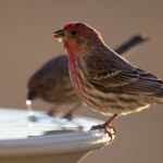 |
Location: My backyard
Shoot type: Wildlife
# of images: 0 | Synopsis: Nothing much to this shoot... I photographed a couple of House Finches drinking at my bird bath in pretty cool back light with nice rim light.
|
| 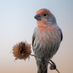 |
Location: My backyard
Shoot type: Wildlife
# of images: 2 | Synopsis: One good image came of this shoot of a Pine Siskin feeding on a dried cone flower seed head. Otherwise, nothing much came of this shoot as I was experimenting with different perches (including the spent cone flowers).
|
|  |
Location: Quivira National Wildlife Refuge, KS
Shoot type: Wildlife
# of images: 2 | Synopsis: This was a brief shoot at Quivira on my way back home after visiting Kansas City and Squaw Creek NWR. On this shoot, I found a large flock of light geese (mainly Snow Geese) on the Little Salt Marsh. They were too far away for any decent images. On NE 170th Rd. on the north side of the refuge, I came across a nice white-tailed buck just after sunset, who was very tame allowing for some nice looks and images.
|
|  |
Location: Squaw Creek National Wildlife Refuge, MO
Shoot type: Wildlife
# of images: 5 | Synopsis: This was my first visit and shoot at Squaw Creek. I got my first taste at photographing Bald Eagles and Trumpeter Swans with some marginal success. I joined up with Mike Hollingshead in the hours following sunrise and we spent some time photographing Bald Eagles in flight. The Snow Geese were not using Squaw Creek, but another lake off refuge for the most part.
|
|  |
Location: Quivira National Wildlife Refuge, KS
Shoot type: Landscape
# of images: 0 | Synopsis: Focusing initially on wildlife, this was largely an unsuccessful shoot given the ongoing drought and lack of water at the time on the refuge. Big Salt Marsh was essentially dry with only pockets of water found near Wildlife Drive. I turned the shoot into more of a drought-landscape shoot after sunrise. I did observe and photograph a couple of Bald Eagles and Sandhill Cranes from a distance.
|
|  |
Location: near my house north of Dodge City, KS
Shoot type: Wildlife
# of images: 1 | Synopsis: I joined up with my friend John Kisner near his house where he had been observing several deer, including some nice bucks, foraging close to sunset in a small wheat field patch along a creek adjacent where he lives. One buck in particular offered some nice views providing for some decent images.
|
|  |
Location: 5 Miles northwest of Dodge City, KS
Shoot type:
# of images: 27 | Synopsis: My neighbors and I documented the shooting and exploding of 4 pumpkins of all sizes.
|
|  |
Location: Private land north of Dodge City, KS
Shoot type: Wildlife
# of images: 0 | Synopsis: A flock of around 100 Lapland Longspurs were flying around the pond on the private land I photographed on this autumn day.
|
|  |
Location: My house
Shoot type: Wildlife
# of images: 0 | Synopsis: Nothing much other than house finches. One finch in particular was trying to drink from the end of the makeshift dripper I had set up, which was kind of humorous looking.
|
|  |
Location: Clark Co. SFL, Kansas
Shoot type: Wildlife
# of images: 1 | Synopsis: I birded with Jeff Calhoun at Clark State Fishing Lake. We observed and photographed a Barred Owl, which is fairly uncommon for this far west. Later on we spotted a Western Grebe through Jeffs spotting scope out on the lake, but it was too far out to photograph.
|
|  |
Location: Quivira National Wildlife Refuge, KS
Shoot type: Wildlife
# of images: 3 | Synopsis: Another awesome morning shoot, out with Jim Glynn again. I photographed an amazing sunrise then focused my attention to some Sandhill Cranes that were gathered on a small marsh northwest of Big Salt Marsh. Later in the morning, we investigated Little Salt Marsh where we counted 18 Whooping Cranes! All these cranes took flight at once headed south out of the refuge. Jim and I chased the cranes south about 10 miles or so. I managed to get 16 Whoopers in one frame in flight -- a truly one-of-a-king shot!
|
|  |
Location: Quivira National Wildlife Refuge
Shoot type: Wildlife
# of images: 3 | Synopsis: I was out shooting with Jim Glynn when we came across three Whooping Cranes on the mud flats north of NE 170th St. We sat there and photographed them from a distance when all of a sudden the three of them took flight...headed straight in our direction! They flew nearly directly overhead providing for some awesome looks at this majestic, endangered species!
|
|  |
Location: Jetmore City Lake, Kansas
Shoot type: Wildlife
# of images: 1 | Synopsis: At the Jetmore City Lake, the light was pretty good this evening, providing for nice images of a Long-billed Dowitcher that was foraging near the west shore of the lake. I also photographed a white-tailed buck in the distance about 20 minutes earlier.
|
| 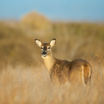 |
Location: Quivira National Wildlife Refuge, Kansas
Shoot type: Wildlife
# of images: 0 | Synopsis: Not much success at Quivira NWR this morning as I tried to spot some Whooping Cranes. None were found, but did manage to photograph a nice looking white-tailed doe after sunrise in good light.
|
|  |
Location: Ford County SFL, Kansas
Shoot type: Wildlife
# of images: 4 | Synopsis: Carried around the 600mm lens to see what I could come up with at Ford County State Fishing Lake. I didnt see much other than a cooperative Dark-eyed Junco (white-winged race, which is a little more unusual).
|
|  |
Location: Horse Thief Reservoir, Kansas
Shoot type: Wildlife
# of images: 1 | Synopsis: Nothing too special here, just a few birds getting used to my new 600mm lens. My first images of a Pine Siskin.
|
| 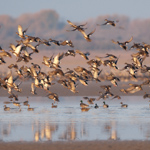 |
Location: Quivira National Wildlife Refuge, KS
Shoot type: Wildlife
# of images: 2 | Synopsis: This was the first shoot with my brand new Nikon 600mm f/4 lens. I photographed from a distance a small flock of Mallards that all took off at the sound of distant gun shots (some off-refuge hunting) as well as a coyote roaming around a group of cranes and waterfowl way off on the other side of Big Salt Marsh. I also photographed some Greater Yellowlegs along Wildlife Drive.
|
|  |
Location: Quivira National Wildlife Refuge, KS
Shoot type: Wildlife
# of images: 1 | Synopsis: I spent some time on Wildlife Drive and in particular the peninsula on the east side of Big Salt Marsh photographing Sandhill Cranes. Cottonwoods were taking on some nice color all around the refuge.
|
|  |
Location: My house
Shoot type: Landscape
# of images: 0 | Synopsis: An impromptu shoot outside my house at the Cottonwoods in color.
|
|  |
Location: Southwest Kansas between Johnson and Syracuse, KS
Shoot type: Weather and Landscape
# of images: 4 | Synopsis: This was kind of a combo chase + landscape shoot near the Colorado-Kansas border. Nothing much of significance came of the shoot, but some of the showers were fairly photogenic with some marginal convective structure in some of them.
|
|  |
Location: West Texas from Plainview to Lockney, TX
Shoot type: Storm Chase
# of images: 4 | Synopsis: I was sorely out of position when the Hale Center-Abernathy supercell developed along I-27. I spent about an hour and a half playing catch up, ultimately getting into the inflow region of the storm north of Lockney. I managed to capture some nice structure + lightning images before the storm went on a downtrend after sunset.
|
|  |
Location: Central KS from Ness City to Rozel, KS
Shoot type: Storm Chase
# of images: 3 | Synopsis: This successful late summer storm chase began west of Ness City late in the afternoon, intercepting a marginal supercell storm upon arrival after leaving work (worked a day shift this day). I followed this storm southeast, navigating mostly county roads through Ness and eventually northeastern Hodgeman and western Pawnee County. Toward sunset, the photography became really good with the supercell establishing multi-tiered structure. I found a brilliant milo field of golden and orange hues which complemented the soft, colorful sky with supercell storm structure to my west...near Rozel, KS. I continued to follow the storm south as several other strong to severe storms formed near the former storm. I managed to capture a few nice cloud-to-ground flashes complete with storm structure after sunset south of Sanford just west of Hwy 183.
|
|  |
Location: My house, 5 miles north of Dodge City, KS
Shoot type: Storm Chase
# of images: 1 | Synopsis: This was a fun shoot "on foot" right outside my house. I ventured over to the north fence line of the empty lot next to my house to photograph some awesome cloud-to-ground lightning after midnight (roughly 12:25 to 12:50am to be more specific). The storms responsible were small with a clear sky full of stars above me and adjacent the small anvils of the storm. The stars above enhanced the photographic scene as I managed to capture several 30s exposures with multiple cloud-to-ground flashes to the north.
|
|  |
Location: West-central Kansas near Leoti, KS
Shoot type: Storm Chase
# of images: 1 | Synopsis: This was a storm chase rather close to home during my midnight shifts at work. After waking up early in the afternoon, I decided to make a go for this chase with a target somewhere west or northwest of Garden City, KS in mind. I intercepted the main storm of the chase between Lakin and Leoti, KS around 6:30pm CDT. The most photogenic portion of the storm was just west of Highway 25 from roughly 6:30 to 6:40pm. After that, the storm lost its decent high-based structure and ultimately wasn't worth chasing. New storms farther north piqued my interest, and I headed north to the Wallace area, but the storms up there sent out a substantial outflow boundary well south of the main precipitation area and was largely unphotogenic. The "golden hour" time frame didn't provide any opportunities either, so shortly after sunset I called it a chase and headed back to Dodge City
|
|  |
Location: Quivira Nat'l Wildlife Refuge, Kansas
Shoot type: Landscape
# of images: 2 | Synopsis: I decided to photograph the drought scenes along Wildlife Drive (a component of the Quivira Nat'l Wildlife Refuge). The shoot lasted about an hour and a half or so photographing various dried up salt marshes and flats, including the Big Salt Marsh along wildlife drive. The sunset was quite photogenic as distant storms spread a band of cirrus clouds with other mid and high-level clouds present to accentuate the sky during this time and enhancing the images.
|
|  |
Location: Southwest Kansas about 12 miles northwest of Dodge City, KS
Shoot type: Storm Chase
# of images: 3 | Synopsis: From a photography standpoint, this was one of my finest storm chases of the year and it was spontaneous, as I had no real intentions of storm chasing this day. This ended up being my best lightning photography shoot of the year to date as I managed to capture numerous cloud-to-ground flashes in good light right around sunset from high-based thunderstorms with semi-transparent precipitation cores. I happened to capture an amazing staccato cloud-to-ground flash at close range with a windmill composed in the shot, which is probably my most rewarding shot of the entire storm chase season. From a pure photography standpoint, this was a 5 out of 5, because the lightning was just excellent and at the perfect time during the so-called photographer "golden hour"
|
|  |
Location: Southwestern South Dakota from Enning to Elm Springs to Badlands Nat'l Park, SD
Shoot type: Storm Chase
# of images: 1 | Synopsis: This was a rather frustrating storm chase that culminated on a positive note. Jay Antle, Evan Bookbinder, and I were targeting along and just north of I-90 east of Rapid City. As storms initially struggled to develop, we became impatient and went after an ongoing storm to our north-northeast, northeast of White Owl, SD. As we reached the town of Enning after driving on unpaved roads, we learned that this storm was severely undercut, and the only way we could get in the proper position was to backtrack down to I-90. As this was happening, a hail storm developed to our south. We eventually got southeast of this storm along I-90 and got into a favorable viewing position when we got into the Badlands National Park. In the park, we photographed the storm which took on some marginal supercell characteristics. At sunset, we drove south of the park along Hwy 44 near Imlay, SD and photographed some marginal mammatus as we also documented some golfball size hail that had just fallen before we arrived.
|
|  |
Location: Southwestern North Dakota north of Rhame, ND
Shoot type: Storm Chase
# of images: 3 | Synopsis: This was a pretty good chase day, as Jay Antle, Evan Bookbinder, and I intercepted a low-precipitation supercell during the mid to late evening hours. We navigated a ranch road north of Highway 12 to photograph the storm to our north, northeast of the town of Rhame, ND. Just after sunset, the upper portion of the cumulonimbus took on a rather spectacular pink glow which provided for some very nice images.
|
|  |
Location: North-central Nebraska from Thedford, NE to the Valentine Nat'l Wildlife Refuge
Shoot type: Storm Chase
# of images: 0 | Synopsis: This chase day started in Belle Fourche, SD, and after a brief tour of the Badland Nat'l Park, we (my storm chase partner Evan Bookbinder and I) set off south-southeast toward developing storms west of the Thedford, NE area. By the time we reached Thedford, though, the storm of interest was dissipating with no further development occurring. We decided to cut our losses and head back to Belle Fourche, catching the sunset along Highway 82 south of Valentine on the way.
|
|  |
Location: Western South Dakota about 10 miles north of Belle Fourche, SD
Shoot type: Weather and Landscape
# of images: 0 | Synopsis: This was a non-storm chase driving day starting in Regina, SK and ending in Belle Fourche, SD. After checking into our motel for the night in Belle Fourche, we decided to head north of town a little bit to catch the sunset as the sky was rather smoke-filled from wildfires out west over western Wyoming.
|
|  |
Location: Southern Saskatchewan from Swift Current to Moose Jaw to Regina, SK
Shoot type: Storm Chase
# of images: 3 | Synopsis: Evan Bookbinder and I intercepted the first storm, an early day elevated supercell, near Swift Current. We followed this storm east along the Trans-Canada Hwy until the structure of the storm became less interesting. We then decided to head east to Moose Jaw to reposition ourselves for the better, late afternoon/early evening show. A supercell formed rapidly about 40 miles to our southwest, and we plotted an intercept down in the Coderre-Courval area. We were in excellent position for a time along Hwy 626, north northeast of Courval, but we needed to go south to Hwy 363 before we could continue east...then eventually back north. During this reposition time, we did observe a distant tornado back to our west-northwest shortly after 6:00pm CDT. After that tornado dissipated, we continued east along Hwy 363 then back north between 6:20 and 6:40pm. During this time, a large tornado was occurring well to our west-northwest that we could not see because of the hilly terrain to our west. We managed to photograph amazing supercell structure, however, during the 6:40 to 6:50 time frame. We followed this supercell to north of Moose Jaw then intercepted approaching menacing squall line with nice shelf cloud structure and cloud-to-ground lightning. We raced east to stay ahead of this, but eventually let it overtake us as we came closer to Regina. At Regina in the wake of the storm, an amazing display of mammatus greeted us, but unfortunately it was in shadow. If it was not in shadow, this mammatus could have the best mammatus both of us have evern seen. All in all, an exciting chase!
|
|  |
Location: Southeastern Alberta & Southwestern Saskatchewan from Oyen, AB to Kindersley, SK
Shoot type: Storm Chase
# of images: 2 | Synopsis: Evan Bookbinder and I intercepted the first storm near Oyen, AB. After refueling at the highway intersection just north of town, we continued east to get back out ahead of it. Once we did, we photographed shelf cloud structure along the way to the Alberta-Saskatchewan border near the town of Alsask. Once we reached Kindersley, we made the decision to let the storm roll by us and photograph the backside of the storm. This turned out to be a good decision, as we observed and photographed an amazing backsheared cumulonimubus to the southeast in brilliant hues of orange, gold, and eventually magenta. Occasional lightning segments up in the anvil near storm summit were also photographed. The color was simply amazing and will be a moment we will never forget, being our first ever trip to Canada!
|
|  |
Location: Glacier National Park, Montana
Shoot type: Landscape
# of images: 2 | Synopsis: This was the second day of my storm chase vacation, and since it was a down day with no storms expected, Evan, Jay, and I drove through Glacier National Park. We drove the entire stretch of the Going to the Sun Road from east to west, photographing the amazing spectacle of sharp mountain peaks, cliffs, glaciers, and countless waterfalls from the ongoing snowmelt. The highlight of this drive was witnessing a wall of snow collapse onto the road very near Logan Pass. This temporarily blocked the road until a bunch of passersby were stopped and helped clear a path. We exited the park at West Glacier then followed Hwy 2 back east toward Browning, MT where we photographed a beautiful sunset just outside of town
|
|  |
Location: Northern Montana north/northwest of Great Falls, MT
Shoot type: Storm Chase
# of images: 1 | Synopsis: This was the first day of my annual storm chase vacation, chasing with Evan Bookbinder and Jay Antle. The three of us intercepted this storm around 8:45pm MDT to the north-northwest of Great Falls, MT after a continuous 1200-mile drive beginning from Kansas City! The storm was high-based and became outflow dominant by the time we reached it, however the structure was decent at times as we photographed it from a distance, east of Dutton, MT.
|
|  |
Location: Southwestern Kansas from Ness City to east of Kalvesta to Jetmore, KS
Shoot type: Storm Chase
# of images: 2 | Synopsis: I left for this storm chase during the mid afternoon hours for a Dighton, KS target. The first storm of intercept was near the Ness City area, and I continued to drop south to catch the southernmost cell of the cluster of storms. The southernmost storm was drifting slowly southwest, so I decided to navigate a dirt road west of Highway 283 in northwestern Hodgeman County. I photographed storm structure including a few lightning flashes. I then photographed what appeared to be a distant landspout type tornado at around 7:15pm CDT, but upon further review, I am not so sure, as it could have been a concentrated pllume of smoke being lifted upward near the supercell updraft. I observed no less than 5 separate grass/wheat stubble fires from the insane amount of anvil lightning that was occurring well away from the primary storm. The supercell became involved in an advancing squall line, and I followed this east back to Highway 283 near Jetmore. South of Jetmore, I photographed the largest of the grass fires I would observe, which was just east of the highway at around 8:15pm.
|
|  |
Location: Southeastern Colorado to far southwestern Kansas from near Pritchett, CO to Big Bow, KS
Shoot type: Storm Chase
# of images: 3 | Synopsis: This storm chase started with the first storm intercept around 3:30pm CDT just outside of Pritchett, CO. This storm was nearly stationary, and I drifted east along Hwy 160 photographing it through the 5 o'clock hour when it began to merge up with several other storms and become less photographable. I met up for a short time with photographer David Mayhew between Pritchett and Springfield. Through some advice from Matt Crowther who was also chasing this storm, I headed north to photograph some mammatus. I played the backside of the storm complex near Johnson, KS and photographed an extremely brilliant double rainbow just east of Johnson. I concluded this chase near Big Bow photographing more awesome, colorful sky scenes at sunset.
|
|  |
Location: My house
Shoot type: Weather and Sky Around Home
# of images: 0 | Synopsis: A couple of westward moving thunderstorms were photographed from my front yard during the evening hours. I played around with the polarizer filter which enhanced some of the images and made for a fairly interesting effect with the small precipitation shafts of one of the storms to the northeast of my house.
|
|  |
Location: Eastern Oklahoma Panhandle around Slapout, OK
Shoot type: Storm Chase
# of images: 1 | Synopsis: A nearly stationary storm formed southwest of Laverne during the early evening hours. After conversing with Matt Crowther, Jeff Piotrowski and others just north of Laverne, I decided to head south and then west along Hwy 412 to near Slapout. After initially going south to photograph storm structure, I drove back north to the Clear Lake, OK area (about 5 miles northwest of Slapout) and photographed a very picturesque narrow updraft with corkscrew appearance. The storm eventually died as sunset approached. I concluded the chase photographing some sunset sky scenes a couple miles east-southeast of Gate, OK along Hwy 64.
|
|  |
Location: Northeastern New Mexico to Northwest Texas Panhandle (Johnson Mesa, NM to Hartley-Dumas, TX)
Shoot type: Storm Chase
# of images: 1 | Synopsis: This chase day was rather frustrating, but I did manage to get some nice images out of a very tiring chase with a ton of driving. I set out for the Raton/Johnson Mesa area early in the day, leaving Dodge City around 7:00am. I reached Raton by early afternoon and then decided to observe the sky atop the Johnson Mesa. Some small storms formed around 2:00pm CDT, and I followed one of them off the mesa southeast to the Des Moines, NM area. This storm never materialized, and I decided to head back northwest in the direction of Raton to catch new mountain storms. I drove all the way back to and up the Johnson Mesa to try my hand at some lightning photography. These storms were not cooperating, and in the meantime, new development was occurring back off to the east again... ugh! So, back southeast it was again on Hwy 64 to Clayton. Storms were really growing to my south-southwest about 90 miles, and I didn't want to end the chase on such a frustrating note, so I set a course to intercept the storms moving into desolate Oldham County, TX. At Dalhart I continued south to Hartley with very electrical storms to the southwest. At Hartley, I continued west to photograph some of the storm structure with nice canyon landscape. Storms were continuing to form all around me, and I was not able to stay ahead of them. I got munched by wind and small hail between Hartley and Dumas along Hwy 87. I then went north about 10 miles north of Dumas to photograph lightning from a new storm to my north-northwest at sunset. I only had marginal success, missing some of the close CG's, unfortunately.
|
|  |
Location: Oklahoma Panhandle from Forgan to Guymon, OK
Shoot type: Storm Chase
# of images: 1 | Synopsis: This was another after work chase. I set out to intercept storms that first developed east of Liberal...hoping for an intercept near the OK-KS border south of Meade State Park. I did not get into the inflow sector of this storm before it crossed Hwy 23...and I received some quarter size hail on the north side of the storm as it passed just south of me. I let this storm go as it was moving into a more stable airmass...opting for new development back to the west and northwest. An isolated storm formed north of Guymon and I decided to intercept this storm. By the time I reached it, though, it was on a downhill trend. I wanted to get on the backside of the storm to capture anything photogenic with the lowering sun angle. I did manage to capture a nice full rainbow with remnant precipitation shaft and small cumulonimbus cloud above it. That was pretty much it for this chase.
|
|  |
Location: Southwest Kansas to Northwest Oklahoma from Englewood, KS to Fort Supply, OK
Shoot type: Storm Chase
# of images: 1 | Synopsis: After working the day shift, I chased a high-based supercell storm that first formed east of Meade, KS. I made it to the inflow sector of this storm at Englewood and continued to follow it south and southeast. The storm was high-based, but revealed some nice scalloped updraft structure at times, especially west-northwest of Buffalo, OK. The storm eventually died without much in the way of redevelopment other than a few small cells back close to the KS-OK border. At close to sunset, there was an amazing display of crepuscular rays which made for nice photography.
|
|  |
Location: Southwest Kansas from Ness City to Brownell to Rush Center, KS
Shoot type: Storm Chase
# of images: 2 | Synopsis: My original target area was south of Dodge City, however no storms were forming in the Minneola to Meade areas, so I had to head back north toward Jetmore and eventually Ness City. A low-precipitation (LP) supercell formed just to my west near Ness City and I followed this storm east to Brownell photographing some of the LP structure as it moved northeast. I let this storm go north of Brownell in favor of a new storm forming to my southwest. I plotted a track to intercept this storm near La Crosse/Rush Center. This storm revealed nice structure and colors at sunset as I photographed it to my northwest. All in all, a fairly fun day of storm photography in southwest Kansas not all that far from home.
|
|  |
Location: Western Nebraska from Big Springs to Hyannis to Merriman, NE and points southeast through the Sandhills
Shoot type: Storm Chase
# of images: 1 | Synopsis: This was a frustrating storm chase. I joined Matt Crowther at Ogallala and we headed to Big Springs where weak storms were trying to initiate. We followed these north all the way to Hyannis, always staying behind the main storm as the storms were racing off to the north at around 45-50mph. Matt and his chase partner broke off and headed back, concluding the chase, but I continued on stubbornly...all the way to Merriman along Hwy 20. I managed to catch a few images of low rolling stratus clouds in filtered sunlight over some sandhills landscape, but that was about it. I got caught in the low stratus and fog on Hwy 20, and dropped back south to Thedford later on in the evening just after sunset.
|
|  |
Location: Central & Southwest Kansas from Liebenthal to Bunker Hill to La Crosse, KS
Shoot type: Storm Chase
# of images: 6 | Synopsis: The first storms I chased were up in the Liebenthal area which became outflow-dominant as they moved east-northeast south of I-70 between Hays and Russell. I eventually made it up to I-70 and followed this storm as far east as Bunker Hill. I photographed some high-based storm structure here, but it was new development way back down to the southwest that caught my eye. I abandoned the northern storms and dropped back south on Hwy 281 at Russell with only one goal in mind: Get in position of Tail-end Charlie (along the Rush-Ness County line). I did make it down there in position at around 8:30pm. From 8:30pm to about 10:50pm, I followed the slow-moving cyclic, tornadic supercell as it rolled across Rush County. I observed no less than 5 tornadoes with this storm. I stayed a bit farther back, capturing storm structure along with the tornado. After dark, I went north of Hwy 4 at Bison about 5 or 6 miles and photographed a beautiful, tall tornado which was lightning illuminated off to my north-northwest. Up through early June, this was certainly the storm of the year for me in 2012.
|
|  |
Location: Southwest Kansas from Ulysses to Copeland to Meade, KS
Shoot type: Storm Chase
# of images: 1 | Synopsis: This was a non-supercell storm chase close to home. Storms first formed in the Ulysses area, and I followed them slowly east. The storms were high-based, but were quite electrical. I managed to capture quite a few daytime lightning images using the Lightning Trigger.
|
|  |
Location: Olathe, Kansas
Shoot type: Storm Chase
# of images: 3 | Synopsis: This was one of those dumb luck chases. I went to the Royals game on May 6th, which was a day game. When I got back to my friend Niki's house, I noticed a storm forming just off to the west. I decided to make a chase of it... why not? It was just 15 miles west of me! I drove west to the northwest side of Olathe and photographed the initial storm which had some decent structure at times. A new cell then formed farther south which would impact far southern part of Olathe. I headed south on K-7 (which turned into Lone Elm Rd.) to 167th St. where the Lone Elm softball fields are. From this location I watched the complete evolution of rotating wall cloud to occlusion to funnel cloud/intermittent tornado off to my north in total amazement! The tornado eventually roped out and the storm went downhill from there, thus concluding the chase.
|
|  |
Location: West Texas & Texas Panhandle from Littlefield to Canyon to Palo Duro Canyon, TX
Shoot type: Storm Chase
# of images: 3 | Synopsis: This was a very underwhelming day with not much in the way of images from this chase. My original target was West Texas northwest of Lubbock near the Littlefield area. Fairly substantial towering cumulus developed along the dryline in the original target area, however there was too much convective inhibition due to the unforecast strength of the bubble high over West Texas. Storms matured over the Amarillo area, so I had to correct back to the north. I didn't get on storms until I reached Canyon. I continued east on FM285 to Wayside and decided to photograph what I could with the Palo Duro Canyon as a backdrop. I didn't get the shots I was hoping for with too much intervening cloud in the way obscuring backside storm structure looking to the east and northeast. At sunset, I went back south back up onto the caprock and photographed the backside cumulonimbus highlighted in orange and pink hues.
|
|  |
Location: West Texas from Levelland to Wolfforth, TX (near Lubbock)
Shoot type: Storm Chase
# of images: 5 | Synopsis: The first supercell formed northwest of Levelland, and I followed it north of town about 6 miles. The storm had menacing High-Precipitation supercell structure as it approached me. I had to bail back south to Hwy 114 near Opdyke as the rear-flank gust front was approaching me. I was in an inflow jet of 50mph with blowing dust reducing visibility at times to near zero! I continued east watching another storm develop just south of the main storm along Hwy 114. I then noticed the next significant supercell form off to the southwest. This storm appeared to be headed for Lubbock, so I drove to Lubbock and south of the city. I photographed long-exposure storm structure from about 8:45 to 9:05pm as the storm rolled through the Wolfforth area just southwest of Lubbock. The inflow dust was rather amazing! I followed this storm east to near Wilson before giving up on it around 9:45pm.
|
|  |
Location: Northwest Texas from near Snyder to Aspermont, TX
Shoot type: Storm Chase
# of images: 2 | Synopsis: I intercepted a high-based supercell north of Snyder during the evening hours. This storm moved east-northeast through a poor road network northeast of Snyder. I photographed lightning and storm structure from north-northwest of Rotan from 8:00 to 8:40pm or so. I continued to photograph lightning illuminated storm structure, albeit not all that great, as I approached Hamlin from 9:00 to 9:30pm.
|
|  |
Location: Southeast Colorado into Southwest Kansas from Bristol, CO to Lakin, KS
Shoot type: Storm Chase
# of images: 5 | Synopsis: After working the day shift, I targeted the Lamar, CO area for a low chance at a picturesque storm after a cold front went through earlier in the afternoon. There was residual moisture behind the front and winds died off in southeast Colorado with up to 1000 J/kg of CAPE in this area. A storm formed rapidly north of Lamar and I intercepted it near Bristol. It quickly took on supercell characteristics as it moved southeast toward Highway 50. I followed the storm east-southeast along Hwy 50 through Syracuse to Kendall, KS. At Kendall is where I got my best images of the supercell around sunset. I continued to shoot the backside of the storm south of Kendall to south of Lakin in the remaining twilight. This was an incredibly photogenic storm and quite the surprise! There was only one other chaser that I know of on that storm on Spotter Network as the majority of storm chasers were in eastern Kansas where the Moderate Risk was.
|
|  |
Location: Southwest Kansas into Northwest Oklahoma from Greensburg, KS to Cherokee, OK
Shoot type: Storm Chase
# of images: 2 | Synopsis: This was the highly anticipated tornado outbreak of which a High Risk was issued by the Storm Prediction Center. I began this chase from Kansas City after attending the Royals Home Opener baseball game the day before. My target was Greensburg, and I observed the first supercell (#1) that moved north of town. I then caught a supercell (#2) farther south which was somewhat high-based as it moved east of Coldwater crossing Hwy 160. I then broke off that storm and intercepted another supercell (#3) which had a rotating wall cloud moving toward Medicine Lodge. I followed this storm northeast toward the Zenda area then broke off of it as it was moving too fast to the northeast. I noticed a pair of supercells in northwest OK that caught my attention and set off for those, which I would reach by around sunset. I intercepted the Cherokee, OK cyclic tornadic supercell (#4) just northeast of Cherokee, observing two tornadoes simultaneously. This was followed by a longer lived, larger tornado near Manchester, OK which then moved northeast away from me. This storm affected Wichita later on in the evening with tornado damage in parts of the southern and southeast Wichita.
|
|  |
Location: Southeast Colorado from Toonerville to Kim, CO
Shoot type: Storm Chase
# of images: 2 | Synopsis: This was a rather frustrating storm chase with not much in the way of images and success. The first storms I chased south of La Junta became an outflow dominant cluster of marginally severe storms as I chased them from north of Kim to Toonerville. Now that I was way out of position, new storms formed back near Kim and points southwest which I tried to get to. I missed the brief tornado that was reported, but finally reached the tail end of this elongated storm about 10 miles west-southwest of Kim which had an interesting, broadly rotating area of scud at ground level before the storm dissipated.
|
|  |
Location: Southwest Kansas from Garden City to Dighton, KS
Shoot type: Storm Chase
# of images: 5 | Synopsis: Intercepted and photographed a fast-moving, small LP Supercell. The storm didn't produce any significant severe weather given its size, but it certainly had fairly decent rotation in the high-shear environment. I intercepted this storm just northeast of Garden City and followed it north along county roads through the panhandle of Finney County into southwestern Lane County before letting it go near Dighton.
|
|  |
Location: Southwest Nebraska near Stapleton, NE
Shoot type: Storm Chase
# of images: 4 | Synopsis: I intercepted and photogrpahed a rare February tornado, the first of which ever recorded in Nebraska. The storm developed almost on top of North Platte, NE and moved almost due north along Highway 83 toward Stapleton. I photographed the tornado from along Highway 83 for about 5 minutes before it dissipated just before reaching Stapleton.
|
|  |
Location: Nebraska Sandhills over southeastern Cherry County, NE
Shoot type: Weather and Landscape,Winter Weather
# of images: 2 | Synopsis: After storm chasing the day before in north-central Kansas, I decided to head up to North Platte, NE for the night and get up really early for a photo shoot over the Sandhills. A fresh snowcover blanketed the Sandhills from the previous day's storm. The shoot began shortly before sunrise along US-83 southeast of Brownlee and ended near Hwy 97 about 25 miles southwest of Valentine by around midday.
|
|  |
Location: North-central Kansas from Lincoln to Minneapolis to east of Concordia, KS
Shoot type: Storm Chase
# of images: 3 | Synopsis: Sub-severe storms developed immediately ahead of a very cold upper low with -30C at its center. Surface temperature/dewpoint was around 55F/44F over the warm sector, which still yielded about 600 J/kg of surface-based CAPE. The most excitment was photographing large quantities of 1/2" to 3/4" diameter hail in the town of Minneapolis (north of Salina, KS). I then photographed a fairly dramatic rainbow at sunset east of Concorida along Hwy 9.
|
Other storm chases that busted/no photography in 2012
|


