| About This Shoot | Date: 12 June 2012 | Location: Southeastern Colorado to far southwestern Kansas from near Pritchett, CO to Big Bow, KS | Shoot Type: Storm Chase | | Synopsis:
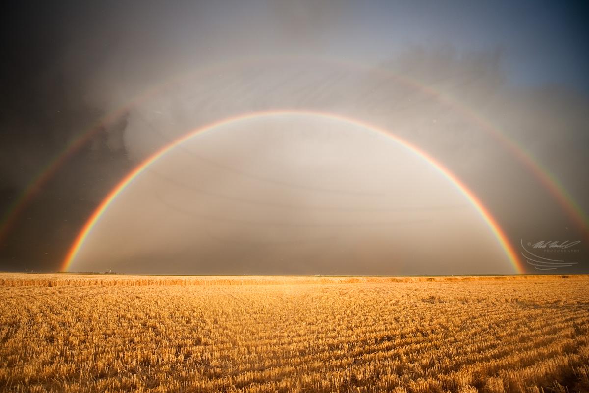
This storm chase started with the first storm intercept around 3:30pm CDT just outside of Pritchett, CO. This storm was nearly stationary, and I drifted east along Hwy 160 photographing it through the 5 o'clock hour when it began to merge up with several other storms and become less photographable. I met up for a short time with photographer David Mayhew between Pritchett and Springfield. Through some advice from Matt Crowther who was also chasing this storm, I headed north to photograph some mammatus. I played the backside of the storm complex near Johnson, KS and photographed an extremely brilliant double rainbow just east of Johnson. I concluded this chase near Big Bow photographing more awesome, colorful sky scenes at sunset. |
|
Other Shoots Around This Date 
2 Jun | 
3 Jun | 
4 Jun | 5 Jun | 6 Jun | 7 Jun | 8 Jun | 9 Jun | 10 Jun | 11 Jun |
12 Jun | 13 Jun | 
14 Jun | 15 Jun | 16 Jun | 17 Jun | 18 Jun | 19 Jun | 20 Jun | 21 Jun | 22 Jun | |
|
Navigate Other Shoots (by year) Navigate Other Shoots (by month)
|
Preliminary Storm Reports from 12 June 2012
 |
1630 UTC SPC Products from 12 June 2012

Categorical Convective Outlook
|

Probabilistic Tornado Outlook
|

Probabilistic Hail Outlook
|

Probabilistic Wind Outlook
|
|
Evening Meteorological Charts from 12 June 2012

250mb Chart
|

500mb Chart
|

700mb Chart
|

850mb Chart
|

Surface Chart
|
|
|
Tue, 12 Jun 2012 23:33:46 -0500
chase recap June 12 |
This post contains audio. Use the embedded QuickTime plugin below to play.
(The audio file is in 3GP format sent via smart phone and requires QuickTime plugin to play)
|
Tue, 12 Jun 2012 13:17:35 -0500
chase update 115pm |
This post contains audio. Use the embedded QuickTime plugin below to play.
(The audio file is in 3GP format sent via smart phone and requires QuickTime plugin to play)
|
Tue, 12 Jun 2012 11:11:21 -0500
Chase Day June 12 Target: Northeast NM to East-central CO. Stage in Lamar, CO by early afternoon with final target decision by around 230pm CDT | I am still a bit torn between the Raton Mesa/Clayton area and the Palmer
Divide/east-central CO area. Despite the early morning MCS in the TX
Panhandle/W TX this morning, moisture is still hanging around the
southern TX Panhandle. The RAP and NAM both show a tongue of moisture
and CAPE extending northward through the central High Plains beneath
westerly mid level flow. It's not the greatest moisture in the world by
any stretch of the imagination, but I think that 1500 to perhaps 1800
J/kg SBCAPE will reach the eastern edge of the Palmer Divide (areas just
east/southeast of Limon). All the high-res models generate some storms
off the Palmer Divide and roll them east-southeast into the moist axis
by early evening. There is a suggestion of more isolated activity in
this area, whereas there is the suggestion in the convection allowing
models of things growing into a small MCS off the Raton Mesa/Clayton
area southward by early evening. I will leave DDC and head to Lamar, CO
for lunch by around 1930 UTC and make a final call at that point.
|
|