3-Month Calendar of Shoots Centered on June 2013 | S | M | T | W | R | F | S | | | | 1 | 2 | 
3 | 
4 | 5 | 
6 | 7 | 8 | 
9 | 
10 | 11 | 12 | 13 | 14 | 15 | 
16 | 17 | 
18 | 
19 | 
20 | 21 | 22 | 23 | 24 | 25 | 26 | 27 | 
28 | 
29 | 30 | 31 |
| | S | M | T | W | R | F | S | | | | | | | 1 | 2 | 
3 | 4 | 5 | 6 | 7 | 8 | 9 | 10 | 11 | 12 | 13 | 
14 | 
15 | 
16 | 17 | 18 | 19 | 
20 | 21 | 
22 | 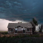
23 | 
24 | 25 | 26 | 27 | 28 | 29 | 30 |
| | S | M | T | W | R | F | S | | 1 | 2 | 3 | 4 | 5 | 6 | 7 | 8 | 9 | 
10 | 
11 | 
12 | 
13 | 
14 | 
15 | 
16 | 
17 | 
18 | 
19 | 
20 | 
21 | 
22 | 
23 | 
24 | 
25 | 
26 | 
27 | 28 | 29 | 30 | 
31 |
|
|
Navigate Other Shoots (by year) Navigate Other Shoots (by month)
|
|
 | |
Location: Southwestern Kansas near Fowler, KS
Shoot type: Storm Chase
# of images: 1 | Synopsis: This was a fun close-to-home chase. I actually started this chase in Sterling, CO and had ideas of chasing down in the Texas Panhandle. However, by late morning, I changed my mind as I was en-route. At Springfield, CO I turned east and went into Southwest Kansas. By early evening, a storm formed near Fowler and it ended up being a very slow-moving marginal supercell, complete with prolific lightning. I meandered slowly south and west.. and at times retraced my steps back to my original shooting location north of Fowler. There was some decent storm structure and the lightning made for a few good frames.
|
| |
Location: Northeastern Colorado between Anton and Otis, CO
Shoot type: Storm Chase
# of images: 3 | Synopsis: After a poor chase forecast, I finally got into position of a supercell storm rolling east toward Anton, CO. I finally got on the storm was just a little bit of daylight left. The best images of the day were after sunset. I found an old farmstead house and used it as the subject of one of my shots with the stark, stormy sky in the background. Later on, I got some lightning illuminated high-based shelf structure as the storm was approaching Otis.
|
| |
Location: Central Nebraska north of Cozad, NE
Shoot type: Storm Chase
# of images: 1 | Synopsis: This day showed quite a bit of potential, but unfortunately a photogenic supercell was not to be. A target storm did develop near Cozad, but after about an hour of struggling to advance to the next stage, it just ultimately shriveled up and died in the capped atmosphere as it moved into the sandhills.
|
| |
Location: West-central Kansas
Shoot type: Storm Chase
# of images: 1 | Synopsis: I decided to go for a late-day/evening storm photography shoot. I was not expecting a whole lot, but the opportunity for some lightning piqued my interest. None of the storms turned out to be worth photographing really. I drove all the way up to Colby as a nice, crisp Cumulonimbus formed to my north-northwest, but by the time I got there, the storm was on a downtrend. I drove back south toward Oakley continuing down into Gove County and photographed a nice virga sky at sunset to the set with some interesting foreground.
|
| |
Location: Southwest Nebraska to Northwest Kansas from Ogallala, NE to Atwood, KS
Shoot type: Storm Chase
# of images: 29 | Synopsis: The keynote sequence of this chase was around and southeast of the Atwood area when a menacing HP supercell formed just south of the NE-KS state line. I followed this storm southeast on a county road grid stopping as often as possible ahead of the storm to take structure shots. It was a very impressive storm which quickly became outflow-dominant. Before this storm, I chased a supercell earlier on with Jay Antle (he broke off the chase at Trenton, NE) which also had some decent structure at times across far southwestern Nebraska.
|
| |
Location: Near Cheyenne, WY to Sterling, CO
Shoot type: Storm Chase
# of images: 3 | Synopsis: I started this chase north of Cheyenne, meeting up briefly with Chris Kirby. I chased with Chris for much of this day, later meeting up with Jay Antle farther southeast on the Colorado side of the Cheyenne Ridge. The initial storm we chased was somewhat photogenic as it moved southeast. We followed it all the way to just west of Sterling. We headed south at sunset in pursuit of new storms developing, which provided for very nice sunset scenes with amazing color.
|
| |
Location: Eastern Nebraska near West Point, NE
Shoot type: Storm Chase
# of images: 3 | Synopsis: I intercepted this supercell thunderstorm on a solo chase in eastern Nebraska. The storm rapidly grew into a supercell storm along an old northwest-southeast oriented outflow boundary. For a time, the storm looked like it was going to produce a tornado, however it failed to do so. Soon, the storm attained incredible multi-tiered structure as it continued to mature. Many great storm structure images were attained along the way, but unfortunately I did not manage to capture any of the crazy staccato cloud-to-ground flashes that were coming out of the storm updraft region. Many of these flashes were way too close for comfort! All in all, it was a very successful intercept. This and the Julesburg storm a couple weeks prior were my best two supercell intercepts of the 2013 season.
|
| |
Location: My House
Shoot type: Weather and Sky Around Home
# of images: 1 | Synopsis: A southeastern sky filled with mammatus thanks to some severe storms about 80 miles to the south of Dodge City.
|
Other storm chases that busted/no photography in
|


