 | About This Shoot | Date: 25 July 2013 | Location: Gila Bend, AZ area mid-afternoon. Salome to Brenda, AZ evening. | Shoot Type: Storm Chase | | Synopsis:
|
|
Other Shoots Around This Date 
15 Jul | 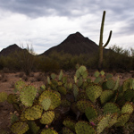
16 Jul | 
17 Jul | 
18 Jul | 
19 Jul | 
20 Jul | 
21 Jul | 
22 Jul | 
23 Jul | 
24 Jul |
25 Jul | 
26 Jul | 
27 Jul | 28 Jul | 29 Jul | 30 Jul | 
31 Jul | 1 Aug | 2 Aug | 3 Aug | 4 Aug | |
|
Navigate Other Shoots (by year) Navigate Other Shoots (by month)
|
Preliminary Storm Reports from 25 July 2013
 |
1630 UTC SPC Products from 25 July 2013

Categorical Convective Outlook
|

Probabilistic Tornado Outlook
|

Probabilistic Hail Outlook
|

Probabilistic Wind Outlook
|
|
Evening Meteorological Charts from 25 July 2013

250mb Chart
|

500mb Chart
|

700mb Chart
|

850mb Chart
|

Surface Chart
|
|
|
Fri, 26 Jul 2013 11:18:09 -0700
Day 15, July 25. Western Arizona Lightning - Salome to Brenda, AZ | Evan and I started the day hoping for some lightning over Tucson from early
afternoon storms viewed from the Catalina Highway (Babad Do'ag Vista). That
was rather unsuccessful, so then we ventured northwest and west along I-8
reaching Gila Bend. We let a storm approach us with all sorts of dust
about 10 miles south-southwest of Gila Bend on Hwy 85. After that failed to
produce lightning for us, we headed for our third storm cluster of the day
in western Arizona as storms moved southwest out of the mountains of
northwestern Arizona. Some of them held together and we finally got some
lightning near the town of Salome, AZ. We then core punched one heck of a
wet microburst with 60-70 mph winds. When we reached the south side of that
storm, we photographed some after-dark lightning near Brenda not far from
the I-10 US-60 junction. Attached to this post is my best image from near
Salome, AZ
| 
(click on thumbnail for pop-up of larger image) |
|


