 | About This Shoot | Date: 21 July 2013 | Location: South of San Simon, AZ | Shoot Type: Storm Chase | | Synopsis:
|
|
Other Shoots Around This Date 
11 Jul | 
12 Jul | 
13 Jul | 
14 Jul | 
15 Jul | 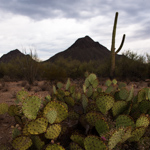
16 Jul | 
17 Jul | 
18 Jul | 
19 Jul | 
20 Jul |
21 Jul | 
22 Jul | 
23 Jul | 
24 Jul | 
25 Jul | 
26 Jul | 
27 Jul | 28 Jul | 29 Jul | 30 Jul | 
31 Jul | |
|
Navigate Other Shoots (by year) Navigate Other Shoots (by month)
|
Preliminary Storm Reports from 21 July 2013
 |
1630 UTC SPC Products from 21 July 2013

Categorical Convective Outlook
|

Probabilistic Tornado Outlook
|

Probabilistic Hail Outlook
|

Probabilistic Wind Outlook
|
|
Evening Meteorological Charts from 21 July 2013

250mb Chart
|

500mb Chart
|

700mb Chart
|

850mb Chart
|

Surface Chart
|
|
|
Mon, 22 Jul 2013 00:27:32 -0700
Day 11, July 21. Storms over Dos Cabezas Mountains | Evan and I started the day with a leisurely drive south through Sonoita
along Hwy 83 then across the beautiful wine country of Elgin, AZ then over
to Whetstone. We briefly monitored weak showers/attempts at storms form off
the Huachucas, until giving that up and heading to Benson for a break and
some lunch. We then set our sights on the Willcox area where we came
across several nice dust devils, including one which came right up on us
(Evan has some cool video of this!) at the Cochise exit of I-10. We finally
chased some storms down coming toward I-10 in the San Simon area. We sat
at a location south of San Simon for up to two hours watching several
storms congeal into one area of bigger storms until ultimately dissipating
all together. We had a really nice looking shelf cloud develop from the
southern storm that came north off Dos Cabezas Mountains. We stopped
briefly for a rainbow shot at the Bowie interchange and made an attempt at
photographing new storms right after sunset down on the other side of Dos
Cabezas Mountains... only to have those storms stop producing lightning as
we got all ready to set up.
| 
(click on thumbnail for pop-up of larger image) |
|


