| About This Shoot | Date: 16 June 2013 | Location: Southwest Nebraska to Northwest Kansas from Ogallala, NE to Atwood, KS | Shoot Type: Storm Chase | | Synopsis:
The keynote sequence of this chase was around and southeast of the Atwood area when a menacing HP supercell formed just south of the NE-KS state line. I followed this storm southeast on a county road grid stopping as often as possible ahead of the storm to take structure shots. It was a very impressive storm which quickly became outflow-dominant. Before this storm, I chased a supercell earlier on with Jay Antle (he broke off the chase at Trenton, NE) which also had some decent structure at times across far southwestern Nebraska. |
|
Other Shoots Around This Date 6 Jun | 7 Jun | 8 Jun | 9 Jun | 10 Jun | 11 Jun | 12 Jun | 13 Jun | 
14 Jun | 
15 Jun |
16 Jun | 17 Jun | 18 Jun | 19 Jun | 
20 Jun | 21 Jun | 
22 Jun | 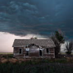
23 Jun | 
24 Jun | 25 Jun | 26 Jun | |
|
Navigate Other Shoots (by year) Navigate Other Shoots (by month)
|
Preliminary Storm Reports from 16 June 2013
 |
1630 UTC SPC Products from 16 June 2013

Categorical Convective Outlook
|

Probabilistic Tornado Outlook
|

Probabilistic Hail Outlook
|

Probabilistic Wind Outlook
|
|
Evening Meteorological Charts from 16 June 2013

250mb Chart
|

500mb Chart
|

700mb Chart
|

850mb Chart
|

Surface Chart
|
|
|
Mon, 17 Jun 2013 20:55:02 -0500
High-based supercell undergoing development with wicked scud cloud formation to the west
Atwood, KS HP Supercell Summary & Images (part 1) | | This sequence of images was from 3:42pm to 3:57pm CDT looking west from a location about 9 miles south of Highway 23 and 7 miles west of Highway 25 southeast of Grant, Nebraska (40.6985016,-101.2869034). Jay and I found this nice overlook at a county road intersection watching the outflow scud forming at ground level and lifting up into the strong updraft of the developing supercell storm. | (click on thumbnails for pop-up of larger images) |
Mon, 17 Jun 2013 21:18:04 -0500
Supercell storm moving south-southeast wrapping some rain curtains in high-based circulation
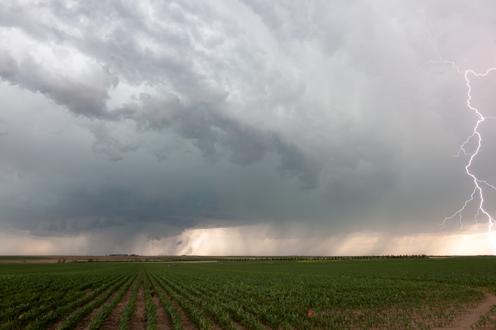
Atwood, KS HP Supercell Summary & Images (part 2) | | A little bit further south than the previous shooting location (40.6283913,-101.2885971), Jay and I observed the storm wrap some rain curtains in a developing rear-flank downdraft region of the storm. A few attempts at funnel cloud wannabes were observed. Cloud-to-ground lightning was frequent enough in the forward flank downdraft/downshear anvil region of the storm to attempt at some Lightning-trigger shots, with one good frame and one better CG that barely caught the right edge of a frame in another shot. | (click on thumbnails for pop-up of larger images) |
Mon, 17 Jun 2013 21:37:01 -0500
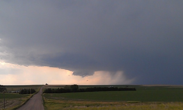
Storm taking on more of a linear appearance and less supercellular near Imperial, NE
Atwood, KS HP Supercell Summary & Images (part 3) |
This particular stopping location was halfway between Hwy 61
and 25, due east of Imperial, NE (40.5318909,-101.2875977) looking almost due west.� Dual
precipitation cores were noted, which provided for some interesting
shots.. including a rainfoot on the northern rain shaft.
| (click on thumbnails for pop-up of larger images) |
Mon, 17 Jun 2013 21:53:54 -0500
High-based structure shots as we continue south through western Hayes County, NE
Atwood, KS HP Supercell Summary & Images (part 4) | | Time around 4:45pm CDT as we stopped briefly for structure shots looking to the west. The storm was taking on more precipitation in the rear-flank. A tall precipitation shaft was also rather cool to see to the northeast of the aforementioned rear-flank precip. Location west of Hayes Center (40.5107002,-101.2119980) | (click on thumbnails for pop-up of larger images) |
Mon, 17 Jun 2013 22:19:26 -0500
Storm structure and lightning with scenic foreground just north of Hamlet, NE
Atwood, KS HP Supercell Summary & Images (part 5) | The storm continued to exhibit non-supercell characteristics as it rolled south-southeast at 5:00pm. We found this nice scenic view on Hamlet Road just north of Hamlet, NE (40.411666, -101.223078) as we continued south on county dirt roads. I managed to capture one cloud-to-ground flash, which I cropped to a panoramic 3:1 image as shown here in Image #3
| (click on thumbnails for pop-up of larger images) |
|