During this 3 day trip, I am hoping for 2 or 3 more fine art/dramatic
storm images to compete with some other dramatic images I've capture
during the 2011 season. I think the opportunity is pretty good to
land some decent storm images with strong/severe photogenic storms a
good possibility each day. The first day, Thursday July 14, I have my
eye on far northeastern Colorado into the Sidney-Big Springs, Nebraska
area. I will be getting off work in Dodge City at around noon and
will drive north toward my target area for evening storms. The
following day, Friday July 15, I have my eye on an area a bit farther
northeast, perhaps centered on the sandhills north of North Platte,
NE. Saturday, the upper ridge really begins to build in a bit more,
which may limit severe weather opportunity a bit with the southern
edge of the upper level southwesterly flow shifting a bit north and
west, but there should still be some terrain-initiated storms off the
Laramie Mts or along a subtle surface trough axis in the southern
Dakotas. Sunday July 17 I will drive back home to Dodge City as I
resume shift work on Monday July 18.
On the second to last day of my storm chase/photography vacation with
Jay Antle, we decided to target the area around the Raton Mesa for the
potential for supercell storms by late afternoon and early evening as
a cold front pushed south overnight and during the day down the high
plains with post-frontal moist upslope winds developing. From
Ogallala, Nebraska, we made the long drive down I-76 and I-25 down to
Raton, arriving mid-afternoon. Showers and weak storms were
developing over the mountains and we decided to monitor this
development from just south/southwest of Raton. Finally, a strong
storm did emerge southwest of Raton which visually had a
well-developed base. It was moving east-northeast toward us, but the
track of the storm appeared to be such that it would go between Hwy 64
and Hwy 56. We decided to take the northern route once the storm
approached I-25. This took us, unfortunately, out of position for
quite awhile, as the storm turned more to the right and was moving due
east if not south of due east a bit. Once we reached Capulin along
Hwy 64, we took an unpaved road south, which we could only average
about 30 mph on due to the rocky nature of the road. We were well out
in front of the storm, but as we headed south on this road, the storm
was rapidly approaching. As Jay drove, I managed to capture a few
images of the storm approaching to the west with decent supercell
structure and dense precipitation core. Once it was clear we were
south of the track of the storm, we finally were able to stop and take
some photos. The storm was on a downtrend, however, as it was getting
close to sunset. We let the storm continue on to the east as we
reached Hwy 56 finally and photographed the backside of the weakening
storm. This essentially sealed the chase day and we drove back west
on Hwy 56 back toward I-25. Before that, however, we stopped one more
time to watch and photograph the world's smallest rotating updraft.
This was rather bizarre, but it was so small, yet the updraft revealed
some barber-pole twisting structure to it. All in all, it was a
successful day in that we photographed a supercell storm, however, I
believe that we would have had a better perspective of the storm had
we dropped south early in the chase south to Hwy 56. We were
positioning ourselves for later in the chase once the storm got into a
better road network, but it just wasn't to be since the storm died
sooner than we had hoped.
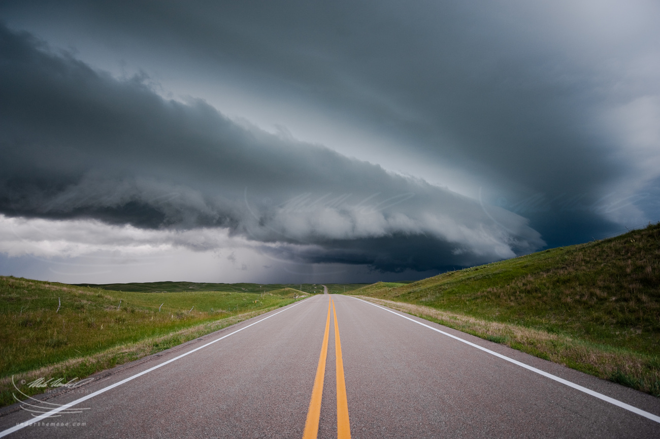
Here are images from around sunset with the incredible saturated
colors to the west behind the shelf cloud approaching us south of
Hyannis, NE along Hwy 61:
Overall, this was a rather frustrating day in terms of supercell
interception. A day that started out with a lot of hope and potential
with very high moisture leading to extreme CAPE over western Nebraska
turned out to be largely a dud of an event. The atmosphere decided to
convect early in the day in the sandhills of northern Nebraska with a
large area of elevated severe storms that moved southeast across
central Nebraska and leaving in its wake a rather large cold pool.
The best surface-based airmass was found to be over extreme
northeastern Colorado and southwestern Nebraska, but this area was
very capped. Jay Antle and I decided to target the area from Oshkosh,
NE to Julesburg, CO. In this area, towering cumulus flirted with
development into storms at times during the afternoon, but the low
level convergence was weakening due to winds responding more to the
elevated heating over the Laramie mountains. Cold frontogenesis was
occurring over central Wyoming, and storms eventually formed over the
Laramies along this front. We gave up on the capped airmass from
Oshkosh to Julesburg and drove west toward towers forming near
Cheyenne. Other storms were visible in the distant northwest through
north. Ultimately, we decided to go after a nice looking storm (both
visually and on radar) well to our northeast near Rushville, NE
entering the sandhills. It was supercellular in nature, and visually
it revealed rock-hard towers with some corkscrewing to the convection.
We blasted east on Hwy 2 from Alliance to make an intercept on this
southeastward moving storm and would be in good position by the time
we reached Hyannis. Problem though. It was moving into the cooler
airmass left behind the earlier day storms. In fact, the airmass was
so moist and not all that warm that low stratus was developing ahead
of the storm. Bad news for photography!! This was really
frustrating. Nevertheless, we continued north to intercept the storm.
It became more elongated on radar, and we were finally greeted to a
wonderful multi-tiered shelf cloud about 15 miles north of Hyannis.
We stopped for a bit to photograph the approaching shelf cloud over
the landscape of the sandhills. We then backtracked to Hyannis and
continued south on Hwy 61 stopping again to let the storm approach us.
We found a decent spot to pull off that had some adequate views
looking west amidst grazing cattle and a small pond. At sunset and on
the other side of the approaching shelf cloud, the sky lit up in
intense orange and magenta hues. The light was incredible, but I wish
it was a bit closer to us! Nevertheless, we got some good photos of
this amazing light with the shelf cloud approaching. This would be
the last of photography for this chase, but at least we managed to
photograph something out of this overall frustrating day. We headed
back to Ogallala, NE for the night.
Below is the sequence of images when we stopped north of Hyannis, NE
for the first look at the approaching storm and shelf cloud:
Sequence of images of the Kimball-Sidney supercell after sunset as
viewed from near the Peetz wind farm north of Crook, CO. The
supercell was shriveling up as it approached Chappell, NE and
eventually dying out towards Big Springs, NE area
Sequence of images of the Kimball-Sidney supercell during the good
"golden hour" light along and just south of I-80 to the Colorado
border south of Sidney:
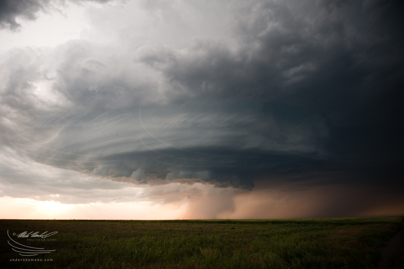
Jay Antle and I intercepted an awesome supercell on Day 10 of this
storm chase trip. Our target was east of the Laramie Mountains as
fairly high CAPE was lurking over the eastern Nebraska Panhandle with
upslope winds increasing by late afternoon and early evening. After
spending some time at Scottsbluff National Monument early in the
afternoon, we set sights on mid afternoon storm development northeast
of Cheyenne. The first storms developed over northern Laramie county
and we drove southwest from LaGrange along Hwy 85 to observe these
first storms. The storms sputtered along as they moved east toward
the Harrisburg area. At Harrisburg, we had to make a decision what to
do next. There were storms trying to get organized up in the Lusk, WY
area well to the north, but what caught our eye more were new towers
forming to our southwest along the outflow boundary left behind from
the first storms that we were following. As a result, we went south
to Kimball. This ended up being a very good call as the group of
towers to our west-northwest organized into an awesome supercell. We
navigated farm roads northeast of Kimball with the storm updraft to
our west-northwest. We tried to remain in the sweet spot
east-southeast of the updraft about 8 to 10 miles to get the good
structure shots of the storm. The supercell cycled through numerous
mesocyclones with a number of wall clouds and occlusions observed. We
also saw a number of dusty spin-ups, mostly caused by RFD hitting the
surface, but one or two of them were fairly intense and cold have been
tornadic. Several persistent mid-level funnel clouds were also seen,
particularly as we were driving south back to Highway 30 northwest of
Sidney. But it was the structure of the storm itself that stole the
spotlight with amazing hues of aquamarine. The bell-shaped nature of
the updraft and the vault just downstream of the updraft itself were
amazing. As the sun was getting lower in the sky, we dropped south
toward the Cheyenne Ridge south of Sidney. More laminar banding of
the updraft was evident, taking on the classic "mothership" appearance
to the northwest. Anvil lightning was frequent overhead with the
persistent, harmonic sound of grumbling going on way up in the upper
troposphere. We continued to stay ahead of the storm south and east,
through the very large Peetz wind farm, and eventually down to Hwy 138
with darkness increasing after sunset. The supercell eventually faded
away late in the evening as it approached the Julesburg, CO and Big
Springs, NE area, but not before putting on a nice display of anvil
zits (short, intense spurts of lightning within the anvil). This
ended up being, for me, the most photogenic supercell of the 2011
season to date.
Below is a sequence of images of the early stages of the supercell
from north of Kimball to northwest of Sidney while we were on the farm
road grid north of Hwy 30: