Day 2 target I will first drive out to Lamar for lunch and then
re-evaluate from there. More than likely I will drive northeast
toward Limon for the first storms coming off the Palmer Divide. CAPE
will be marginal at best for severe weather/supercells with 800 to
1200 J/kg expected in marginal moisture of mid 40s to near 50
dewpoint. The deep layer shear is great, however, and the early runs
of the HRRR model depicts supercell looking simulated composite
reflectivity "blobs" in east-central Colorado later this afternoon.
So there is some hope.
Outlook: Day 3 (Saturday) will be in the same general area, so
wherever I end up tonight, I will probably lodge near there for the
night (Burlington or Goodland?) instead of driving back to Dodge only
to go right back out there the next day. After Saturday's chase, I
will drive back to Dodge City to pick up Jay Antle who will drive to
my house late Saturday night or early Sunday morning. Sunday and
Monday look like definite chase days as a nice trough approaches the
plains. Tuesday could be another chase day farther south along the
trailing front in northwest Texas/southern Oklahoma or it could be the
beginning of a nice long drive to the northern High Plains (Montana?)
to get ready for the next Pacific jet to impact the northwest yielding
chase opportunities way up northwest by Thursday of next week. This
is still speculative, though, with a lot to potentially change (and it
probably will).
The day started out with two targets in mind: One was around
northeast Colorado and adjacent far southwest Nebraska/northwest
Kansas and the other was along an outflow boundary from morning storms
with a minor disturbance in the mid levels moving into far southwest
Kansas. I decided to chase the southern target and had the luxury of
hanging out at my house most of the day to watch the atmosphere unfold
(both visually and remotely on the internet). Mid level altocumulus
(accas) and showers were developing over Baca County early in the
afternoon and were moving northeast into KS. The HRRR model was
aggressive and persistent in developing this area of mid level accas
and virga/showers by late in the afternoon. Soon, it became evident
that new surface-based cumulus was forming to the west and southwest
ahead of the accas. Storm chasers Brandon Sullivan and Mike Scantlin
stopped by my house to look at data, since this was their target area
as well. Separately, we departed south toward Minneola and along the
drive, towers were forming southeast along the outflow boundary.
Observations showed 66-67F dewpoint air on the northeast side of the
outflow boundary. The problem was, that surface-based air had high
inhibition since it was some 15 degrees cooler than the 104-106F heat
on the other side of the outflow boundary. This was a problem. These
storms that formed on the outflow boundary quickly moved northeast and
were essentially elevated above the outflow boundary. The storms
looked like crap, visually, and strong 25-35mph southeast winds...
very moist... were essentially blowing right underneath these storms
(one was north of Greensburg and the other was southwest of Pratt.
The storm northwest of Greensburg actually produced a small mid-level
funnel cloud, but it was totally benign. I saw this storm going
nowhere, and at the time, I was actually becoming a little more
interested in the Pratt storm since it was getting more aggressive on
radar... plus it was tail-end (even if it was slightly elevated).
Sometimes slightly elevated storms can transition to surface based if
the updrafts get extremely intense. I went to Pratt... got to the
other side of the storm...and it too looked like crap. This was
frustrating.
Then, in no time, the Dodge City storm all of a sudden back to the
west (which I had not originally gone after because I thought it was
becoming a linear piece of garbage) was taking on a different
character. I drove back west through Pratt and on my way to
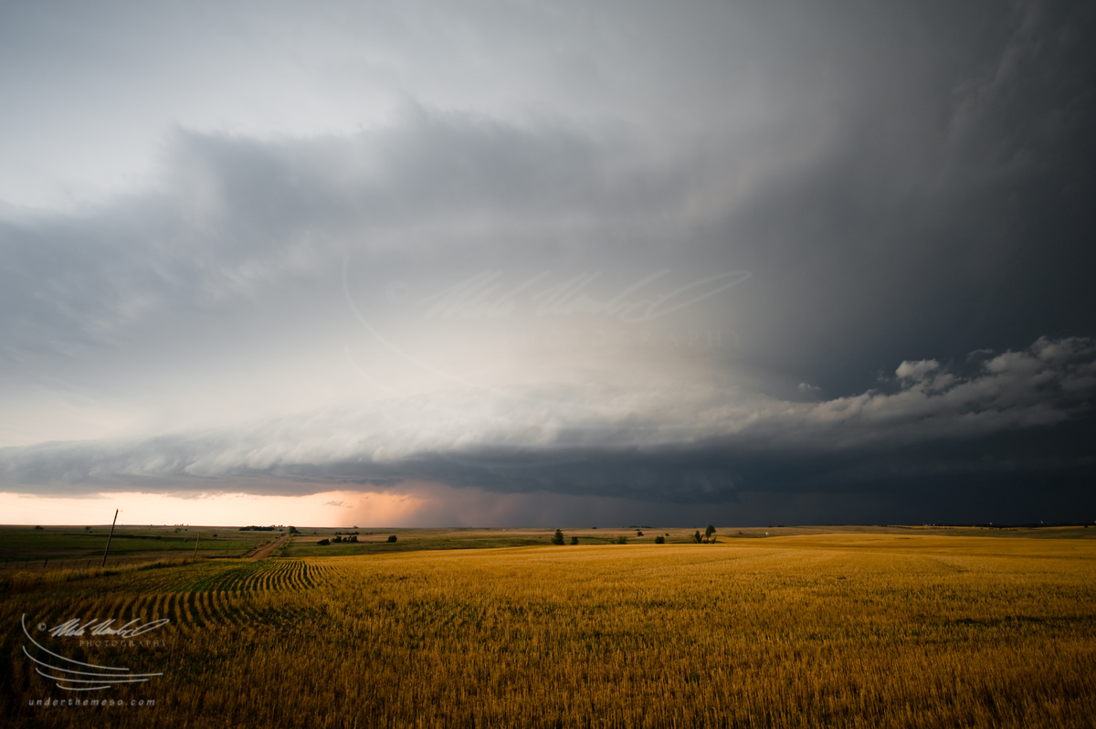
Haviland-Greensburg. I arrived at Haviland and observed some fairly
decent HP supercell updraft structure to my northwest. I photographed
this for a little bit then continued on west to Greensburg as
supercell was really getting its act together near Bucklin. I drove
west on Hwy 54 to near Mullinville where I set up the tripod for the
first series of images. I then back-tracked to Hwy 183 at Greensburg
and shot south about 7 or 8 miles to a nice viewing point along a
county road. My best images of the day came from this spot with
fairly classic supercell storm structure. The storm went on to
produce a menacing lowering/wall cloud, but I never noted any
significant cloud base rotation (plus, the visibility back in there
was rather poor). After this sequence of events and the storm
continuing to move east... I decided to head south to the
Kiowa-Comanche county line and go east a bit where I took my last set
of images from along the county line east of Hwy 183. The supercell
structure was becoming a little bit less impressive and the rear flank
gust front shelf cloud was kind of overtaking the structure from my
perspective. I then proceeded to let the storm go by me as I drove
back north toward Greensburg on Hwy 183. As I approached Greensburg,
I was buffeted by 60+ mph east winds behind the storm... which was a
difficult cross wind to drive in (even at a reduced 50 mph). By this
time, the sun had already set, so I was too late for behind-the-storm
photography in waning sunlight. There were some nice anvil zits
(lightning) behind the storm, but low clouds were interspersed among
the storm's backside faint mammatus/lightning and unfortunately did
not make for good photography. I ended the chase at this point and
headed back home.