Mike Umscheid Photography & Storm Chase Blog
* *  Mike Umscheid PHOTOGRAPHY & STORM CHASE BLOG   * *


Navigate Other Shoots (by year)
2020
2019
2018
2017
2016
2015
2014
2013
2012
2011
2010
Navigate Other Shoots (by month)
July 2020
June 2020
May 2020
April 2020
March 2020
February 2020
November 2019
September 2019
August 2019
July 2019
June 2019
May 2019
April 2019
February 2019
September 2018
August 2018
July 2018
June 2018
May 2018
April 2018
March 2018
February 2018
January 2018
December 2017
November 2017
October 2017
September 2017
August 2017
July 2017
June 2017
May 2017
April 2017
March 2017
February 2017
January 2017
December 2016
November 2016
October 2016
August 2016
July 2016
June 2016
May 2016
April 2016
March 2016
February 2016
January 2016
November 2015
October 2015
August 2015
July 2015
June 2015
May 2015
April 2015
February 2015
January 2015
December 2014
November 2014
October 2014
September 2014
August 2014
July 2014
June 2014
May 2014
April 2014
March 2014
February 2014
January 2014
December 2013
November 2013
October 2013
September 2013
August 2013
July 2013
June 2013
May 2013
April 2013
March 2013
February 2013
January 2013
December 2012
November 2012
October 2012
September 2012
August 2012
July 2012
June 2012
May 2012
April 2012
March 2012
February 2012
December 2011
October 2011
August 2011
July 2011
June 2011
May 2011
April 2011
June 2010
May 2010
April 2010
February 2010
January 2010

<<  Previous Page        Next Page  >>    Top Page

Sat, 13 Oct 2012 13:22:12 -0500
Cumulus congestus forming near liberal 120pm
  
(click on thumbnail for pop-up of larger image)

Sat, 13 Oct 2012 12:31:46 -0500
Slapped back into reality 65 dewpoint at Buffalo,OK. There are better days for cold core play. Back to orig. target

Sat, 13 Oct 2012 10:50:15 -0500
bailing original target. going cold core KS CO border

This post contains audio. Use the embedded QuickTime plugin below to play.
(The audio file is in 3GP format sent via smart phone and requires QuickTime plugin to play)

Sound file link

Sat, 13 Oct 2012 08:39:19 -0500
Today 10/13 is a chase day. Target Kiowa to Kingman, KS
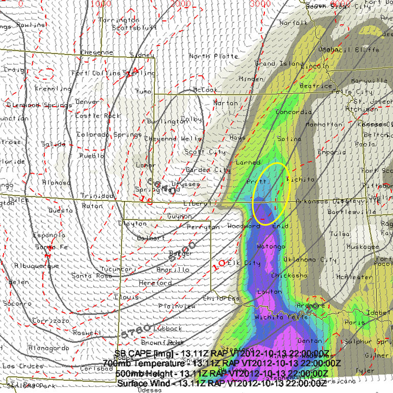
I had no intentions of storm chasing today, but since the upper level
trough as slowed down and there is a better mid level vorticity center
farther southwest than what models have shown over the past couple of
days, there will be an interesting play for late-day storms as far west
as Barber County, KS today. My target is Kiowa, KS and points northeast
from there toward Kingman, KS. I will be leaving Amarillo by 930am or
so for an early afternoon staging point around Woodward, where I'll
refine my target and grab some lunch.
  
(click on thumbnail for pop-up of larger image)

Sat, 13 Oct 2012 00:01:20 -0500
In Amarillo tonight instead of driving back to Dodge. Tomorrow now looks like chase day for me since system slowed down

Fri, 12 Oct 2012 23:50:51 -0500
Hale Center, TX Supercell toward the end of its life with lightning and a power flash. 12 October 2012
  
(click on thumbnail for pop-up of larger image)

Fri, 12 Oct 2012 21:18:14 -0500
Chase is done.. in Tulia, TX grabbing a bite to eat, drive back to Dodge, probably home by 2am.

Fri, 12 Oct 2012 20:57:22 -0500
Wow. managed to photograph late stages of Hale Center TX supercell. structure+tall lightning+glowing transformers!!

Fri, 12 Oct 2012 18:15:08 -0500
Nice Cb north of Lubbock!
  
(click on thumbnail for pop-up of larger image)

Fri, 12 Oct 2012 16:19:27 -0500
417pm, 2 cells east of clovis moving quickly northeast, weak now, will continue east on hwy 86

<<  Previous Page        Next Page  >>    Top Page