| About This Shoot | Date: 11 October 2011 | Location: Eastern Texas Panhandle from Pampa to Alanreed, TX | Shoot Type: Storm Chase | | Synopsis:
Intercepted a beautifully sculpted supercell thunderstorm that first started off as a run-of-the-mill hailstorm in Pampa. The storm rapidly organized into a supercell southeast of Pampa as it rolled southeast through the ranch land of Gray County near the town of Lefors. I photographed the storm in amazing evening light from the Texas Highway 70 corridor west/southwest of the storm. |
|
Other Shoots Around This Date There are no other photography shoots or storm chases around this date (+/- 10 days)
|
Navigate Other Shoots (by year) Navigate Other Shoots (by month)
|
Preliminary Storm Reports from 11 October 2011
 |
1630 UTC SPC Products from 11 October 2011

Categorical Convective Outlook
|

Probabilistic Tornado Outlook
|

Probabilistic Hail Outlook
|

Probabilistic Wind Outlook
|
|
Evening Meteorological Charts from 11 October 2011

250mb Chart
|

500mb Chart
|

700mb Chart
|

850mb Chart
|

Surface Chart
|
|
|
Fri, 14 Oct 2011 03:40:19 -0500
Pampa hailstorm
Pampa-Lefors, TX Supercell Summary & Images (part 1) | |
Pampa hailstorm. After a hearty lunch in Amarillo and a
brief visit to Palo Duro Canyon S.P., I began my chase by heading
north back into eastern Amarillo then east on I-40 to Conway. I was
most interested in a cluster of towering cumulus to my north about
20 to 30 miles away. These towers festered for awhile as I watched
from a truck stop at Conway along I-40 and Highway 207. An echo
soon became apparent on radar tied to the healthiest looking updraft
tower to my north-northeast, so I drove north toward Panhandle.
This was the birth of the initial hailstorm that went on to affect
Pampa. I followed the storm northeast on Highway 60 toward Pampa,
experiencing some pea size hail along the way from Kings Mill to the
southwestern portion of Pampa. I decided to head north just a
little bit on the west side of town on Ranch 282 and found a place
to observe the onslaught of hail near the intersection of Ranch 282
and Highway 152. The hail lasted 5 to 7 minutes around 5:45pm or so
and covered the ground for a brief period of time with the hail only
as large as penny to nickel size at the largest.
| (click on thumbnails for pop-up of larger images) |
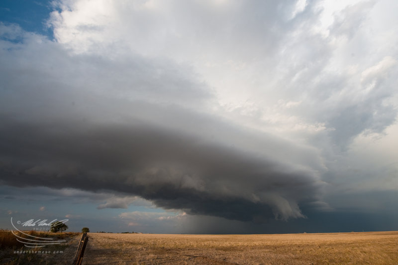
A new, more significant updraft emerges south of Pampa. Go south or southeast?
Pampa-Lefors, TX Supercell Summary & Images (part 2) |
So, I departed Pampa after the hail ended, but
I wasn't entirely sure whether to go southeast or due south. I saw
the new big updraft base to my immediate south/southwest and had a
strong feeling that would be supercellular very soon... and move
straight southeast or even south-southeast. I also weighed in the
possibility that photography light might be better being due south
or even southwest of the primary updraft. I was on Highway 273 just
south of Pampa and decided to take Highway 70 south...instead of
Highway 273 southeast to Lefors. Here are a few images of the early
stages of the updraft base about to really ramp up and take on
supercellular characteristics... at around 6:20pm... about 5 miles
south of Pampa just east of Highway 70:
| (click on thumbnails for pop-up of larger images) |
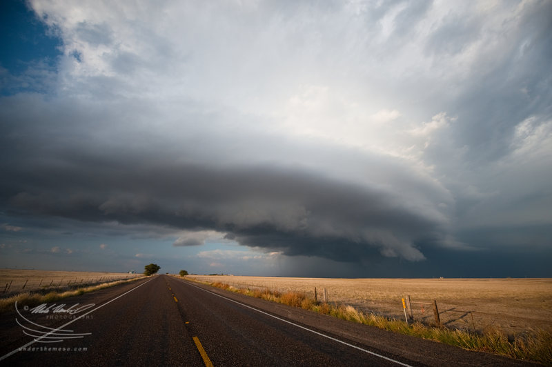
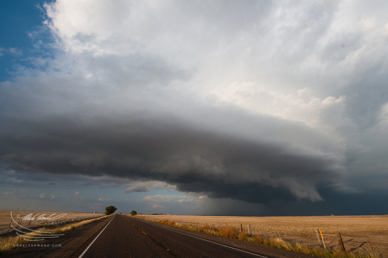
Supercell structure emerges to the northeast.
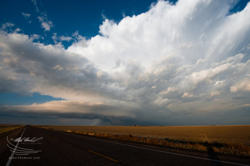
Pampa-Lefors, TX Supercell Summary & Images (part 3) |
I continued my
drive south on Highway 70 south of Pampa to stay ahead of the main
updraft area, and in doing so, the structure of the supercell became
much improved. As viewed from the south-southwest, the storm
structure was quite impressive with a long rear-flank gust front
approaching me along Highway 70 and multi-tiered banded structure of
the main updraft area farther to the northeast. Here are a few
images during that stage shortly after 6:30pm:
| (click on thumbnails for pop-up of larger images) |
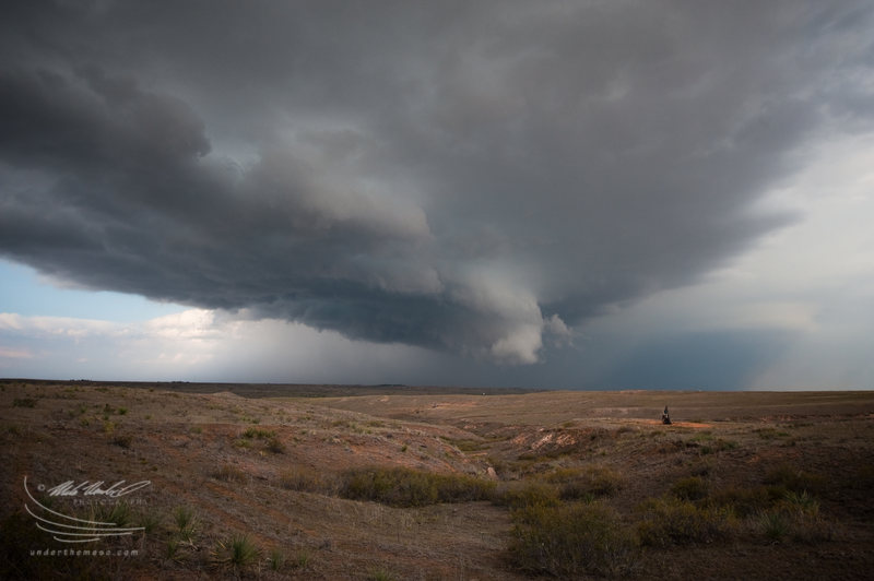
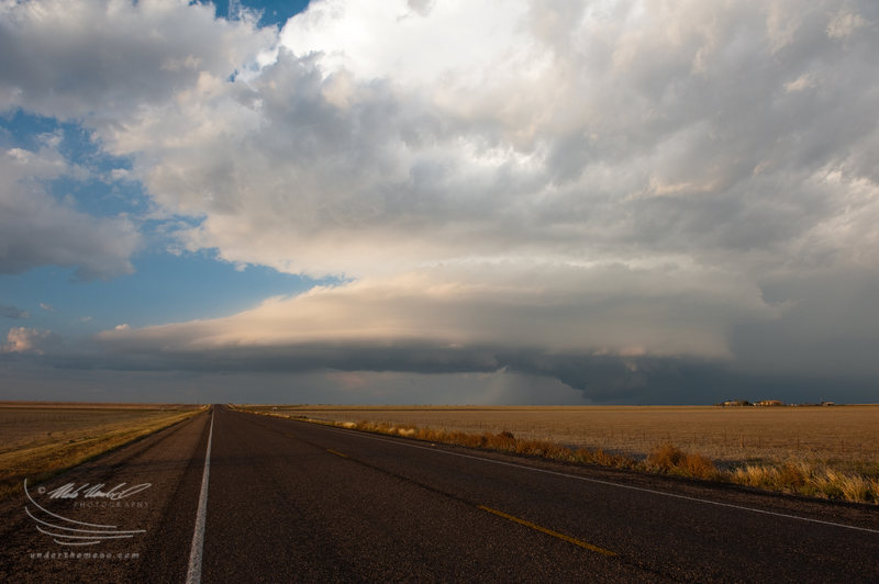
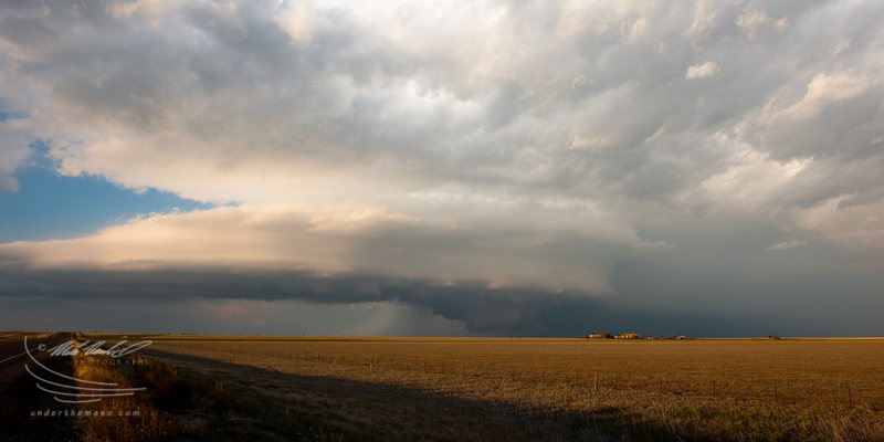
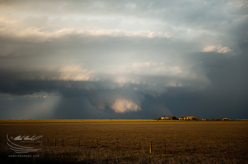
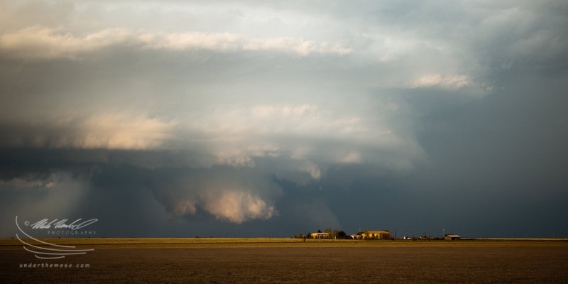
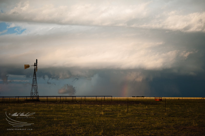
A formidable wall cloud emerges
Pampa-Lefors, TX Supercell Summary & Images (part 4) |
About 10 to 15 minutes later, farther south along Highway 70 (probably 12 miles or so south
of Pampa), I stopped again to photograph the storm structure to my
northeast. The sun was getting lower and the light was improving
(becoming softer). To my surprise, a big, blocky wall cloud emerged
beneath the base of the supercell. For a moment, the bottom portion
of the wall cloud was being illuminated by the sun. I used a
distant farm house to my advantage as a foreground subject to the
wall cloud farther back. The rear flank gust front had a rather
striated look to it as it extended a good distance
west-southwestward from the wall cloud area. Time of the following
images around 6:45pm:
| (click on thumbnails for pop-up of larger images) |
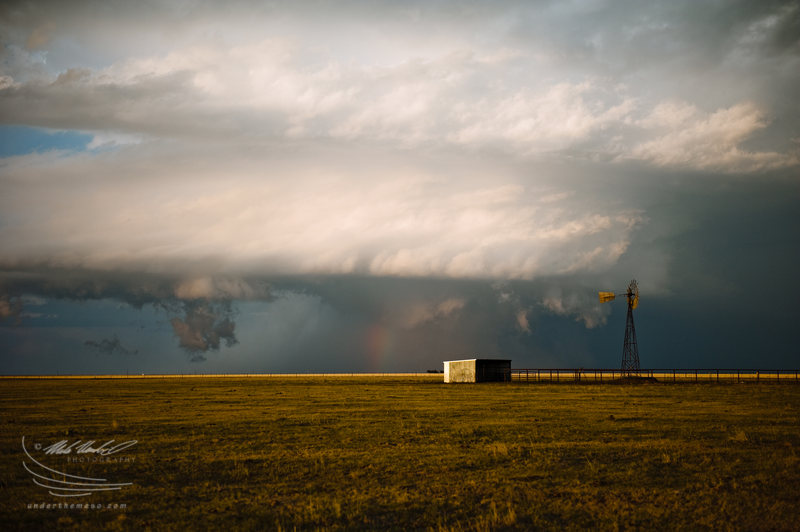
Using a windmill to my advantage as storm structure consolidates
Pampa-Lefors, TX Supercell Summary & Images (part 5) |
I wanted to drive east a little bit off of
Highway 70 to try to get a little closer to the primary updraft
area, so I took one of the several unpaved roads that went east a
couple miles before dead-ending. Along the way on one of these
roads, I came across a windmill -- one of my favorite subjects to
shoot with storms -- and just went to town photographing the awesome
scene at around 6:50pm:
| (click on thumbnails for pop-up of larger images) |
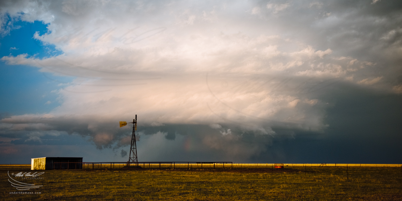
Wide angle storm structure
Pampa-Lefors, TX Supercell Summary & Images (part 6) |
From the same location, I also
photographed a few wide angle images with the windmill at
around 7:00pm as the supercell storm continued to move southeast
near Lefors, TX:
| (click on thumbnails for pop-up of larger images) |
The mothership at sunset!
Pampa-Lefors, TX Supercell Summary & Images (part 7) |
After photographing the sequence
at the first windmill, I continued south on Highway 70 a few more
miles and went east on Ranch 2477 (the road to Lake McClellan). I
stopped again when I came across another windmill, only this one
without blades... and used this as a foreground subject to
photograph what was now becoming an incredible striated barrel
updraft to my east. It was right around sunset time at about 7:10
to 7:15 when I photographed the sequence of images below:
| (click on thumbnails for pop-up of larger images) |
Structure at twilight near Lake McClellan
Pampa-Lefors, TX Supercell Summary & Images (part 8) |
I continued east
and southeast on Ranch 2477 stopping intermittently along the way to
I-40 after sunset to photograph the structure of the supercell off
to the east. There was a left-split storm moving northeast to
eventually merge with the main supercell storm, although this ended
up being more of a destructive merger (in combination with the fact
that instability was rapidly declining with loss of insolation).
When I got to I-40, I continued east to Alanreed and went south on
Ranch 291, but by this point, the storm was not photogenic anymore
and the rising full moon was in a bad position providing harsh light
in the direction of the decaying and departing storm. All in all,
this was one incredible chase for October -- probably the most
impressive supercell, structure wise, I have photographed in the
month of October.
| (click on thumbnails for pop-up of larger images) |
Tue, 11 Oct 2011 10:07:12 -0500
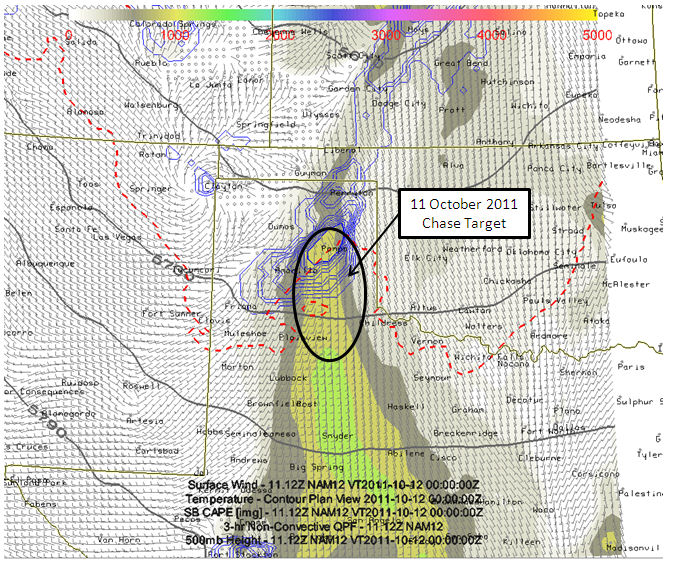
Chase Day 11 October 2011. Target: Eastern Texas Panhandle from Pampa to Turkey | I left Dodge City early this morning for a lunchtime destination of
Amarillo. After lunch, I will hone in on a more defined target
somewhere not too far east of Amarillo. Today appears to be a good
storm day with excellent deep layer directional shear, some surface
moisture, and cool mid level temperatures (around -14C at 500mb). This
is expected to result Surface-based CAPE around 1000-1300 J/kg. If
higher moisture can be realized (like what the RUC and HRRR suggest),
then SB CAPE may approach 2000 J/kg locally... especially southeast of
Amarillo. Storms should form in surface convergence near or just east
of Amarillo by 4 or 5pm and become supercells shortly thereafter. At
least that is the hope, and the reason I decided to make a run at this
autumn storm chase. Plus, the prospects of photographing a nicely
structured storms in the canyon lands is too good to pass up. So here's
to some October Panhandle Magic! -Mike U
| 
(click on thumbnail for pop-up of larger image) |
|