Pampa hailstorm. After a hearty lunch in Amarillo and a
brief visit to Palo Duro Canyon S.P., I began my chase by heading
north back into eastern Amarillo then east on I-40 to Conway. I was
most interested in a cluster of towering cumulus to my north about
20 to 30 miles away. These towers festered for awhile as I watched
from a truck stop at Conway along I-40 and Highway 207. An echo
soon became apparent on radar tied to the healthiest looking updraft
tower to my north-northeast, so I drove north toward Panhandle.
This was the birth of the initial hailstorm that went on to affect
Pampa. I followed the storm northeast on Highway 60 toward Pampa,
experiencing some pea size hail along the way from Kings Mill to the
southwestern portion of Pampa. I decided to head north just a
little bit on the west side of town on Ranch 282 and found a place
to observe the onslaught of hail near the intersection of Ranch 282
and Highway 152. The hail lasted 5 to 7 minutes around 5:45pm or so
and covered the ground for a brief period of time with the hail only
as large as penny to nickel size at the largest.
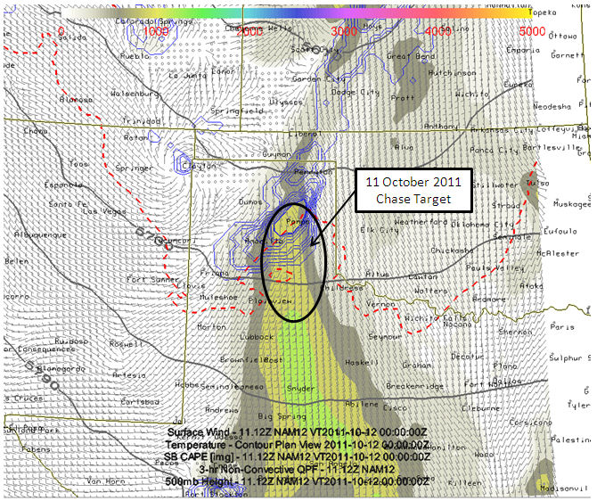
I left Dodge City early this morning for a lunchtime destination of
Amarillo. After lunch, I will hone in on a more defined target
somewhere not too far east of Amarillo. Today appears to be a good
storm day with excellent deep layer directional shear, some surface
moisture, and cool mid level temperatures (around -14C at 500mb). This
is expected to result Surface-based CAPE around 1000-1300 J/kg. If
higher moisture can be realized (like what the RUC and HRRR suggest),
then SB CAPE may approach 2000 J/kg locally... especially southeast of
Amarillo. Storms should form in surface convergence near or just east
of Amarillo by 4 or 5pm and become supercells shortly thereafter. At
least that is the hope, and the reason I decided to make a run at this
autumn storm chase. Plus, the prospects of photographing a nicely
structured storms in the canyon lands is too good to pass up. So here's
to some October Panhandle Magic! -Mike U
(click on thumbnail for pop-up of larger image)
Short videos from my HTC smart phone during 12 August 2011 chase in Southwest Kansas:
Severe storms organizing near Offerle, KS, including a rainfoot to my north:
Severe storms organizing west of Kinsley, KS:
Along Highway 54 just west of Pratt as a menacing severe storm approaches with 60-80mph winds about to come into Pratt:
A likely vortex of some sort... this feature was in the cyclonic shear area on the north side of the significant straight line wind event occurring farther to the south. Radar did reveal weak low level rotational signature near here... more of a "bookend vortex" type signature than anything else:
Near Spivey, KS ahead of a menacing shelf cloud leading 60-70mph winds: