Jay and I continued to follow this storm south during the mid to late
evening hours southeast of Rolla, KS into the Oklahoma panhandle north
of Guymon. The sequence of images shown here span about 20 minutes or
so from about 8:15 to 8:40pm showing the striated structure of the
high-based updraft as we were near the Oklahoma-Kansas border. New
storms were forming farther to the west which would eventually put on
an amazing cloud-to-ground lightning show in the saturated twilight
(see Part 3 below).
June 28th was the final day of my 2011 storm chase trip with Jay
Antle. We departed Raton, NM late morning and made a leisurely drive
through the mesas east of Raton, including Johnson Mesa as well as a
trip to Capulin Volcano (always a favorite). We then took the scenic
drive along Highway 456 just south of the Colorado border... east to
Kenton. We transitioned into chase mode as we set sights on the
Springfield, CO area where we were conveniently greeted to the first
storm of the day with decent cloud-to-ground lightning (first image in
the sequence below). We followed these storms east toward Walsh and
continued on into far southwest Kansas when storms really started to
get their act together northwest of Richfield. A series of formidable
gustnadoes developed in front of us along one of the dirt roads we
were traveling along. We continued east on pavement along Hwy 27 and
eventually reaching Hwy 51. At that point, the storm evolved into a
series of high-based storms in a psuedo-linear fashion, but had nice,
organized updraft structure and a lot of blowing dust action beneath
(continued in Part 2...)
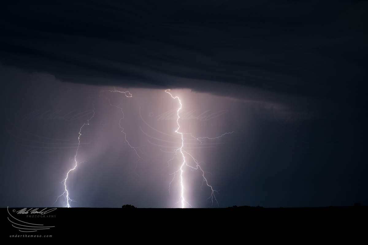
On my way home to Dodge City following the previous night's chase in
southern Nebraska, I came across nocturnal storms that were rather
electrical... making for a very nice photography opportunity! Because
of this, however, I didn't roll into my driveway until about an hour
after sunrise shortly after 7:00am! It was worth it :)
It became quite clear that the storms in north-central KS were just
not going to mature into something worth chasing. An outflow boundary
from the small cluster of storms I was chasing was really spreading
east well ahead of the actual storms. The northern outflow boundary
surged north into south-central Nebraska, and a severe storm
eventually formed along this outflow boundary to the north. I decided
to go after this storm, but it was an extremely frustrating intercept.
I never really did get any good images of the storm itself as it
moved north at a fairly decent clip toward Hastings, NE. I finally
managed to stop somewhere between Hastings and Ayr, but when I got out
of the car to set up to shoot, my glasses and my camera lenses
immediately "fogged over". The dewpoint temperature was near 80
degrees!! It was extremely humid, accentuated by the very tall corn
growing around this part of Nebraska. This made stopping to
photograph a very tough task since the 9-foot tall corn stalks were
obscuring the horizon line in many areas. This was extremely
frustrating. Finally, I decided to just bust it west to get on the
other side of the storm to see what kind of scenes I could photograph
on the back side. A brilliant rainbow emerged about 10 miles west of
Hastings, but when I went south on a paved road down to Holstein,
there was a) no place to pull off to shoot and b) the east wind
driving the rain made it impossible to shoot this rainbow in
incredible light without drenching my gear and getting a rain drops on
the lens effectively making any clean shot an impossible task. So as
I drove south, the rainbow ultimately faded away without one image of
it. I wish I had that back, because the corn field and a few
beautiful barns with this vivid rainbow would have made calendar-type
images. I continued west with flanking towers developing to my north.
Other storms developing over northwestern Kansas were moving
northeast toward the Beaver City, NE area and I had decided to just
head west in hopes that these would further develop. They eventually
died, and I turned around to try and keep up with the backside of the
Hastings, NE storm complex, which was now approaching I-80. I drove
all the way up to Grand Island and pretty much called it a chase at
that point. Although it wasn't before I got one last image of a
decent cloud-to-ground lightning flash adjacent a power plant and tall
corn field in the foreground. I got some dinner in Grand Island and
decided to make the long drive back to Dodge City, ending this two-day
chase trip. But there was one last photography opportunity awaiting
on my way back home to Dodge City!
See the July 16 chase account
After the initial Kirwin storm more or less dissolved with a bunch of
other weak storms developing all around it... the focus turned more
toward lightning. I managed to capture some decent daytime
cloud-to-ground flashes with the lightning trigger as I followed the
cluster of storms east across Smith County, KS southeast of Smith
Center from about 4:15pm to shortly after 5:00pm:
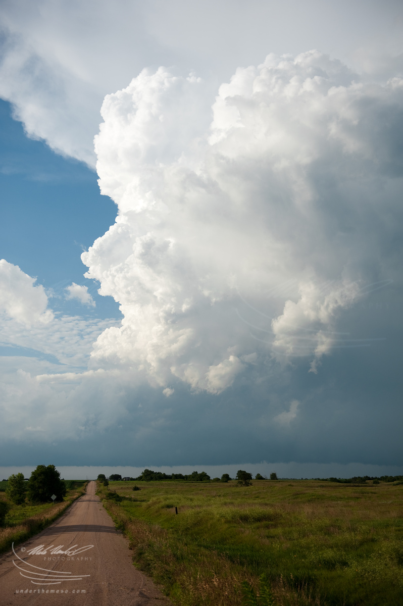
The first set of images are from the first storm I intercepted on 15
July near Kirwin, KS. This first storm showed some promise at
developing into a formidable storm, and while it did briefly reveal
some decent storm structure, it never really made it to the next level
and quickly became outflow dominant (not surprising with temperatures
over 100 degrees). The deep moisture was still just a little bit to
the east of the Kirwin area at this time. I manage to photograph a
decent rainfoot to my southeast from near the north side of the Kirwin
Reservoir: