Mike Umscheid Photography & Storm Chase Blog
HOME
*L I V E CHASE MODE!*
BLOG
GALLERY
NEW RELEASES
2016 SHOOTS
ORDERING INFO
* * Mike Umscheid PHOTOGRAPHY & STORM CHASE BLOG * *
Navigate Other Shoots (by year)
2020
2019
2018
2017
2016
2015
2014
2013
2012
2011
2010
Navigate Other Shoots (by month)
July 2020
June 2020
May 2020
April 2020
March 2020
February 2020
November 2019
September 2019
August 2019
July 2019
June 2019
May 2019
April 2019
February 2019
September 2018
August 2018
July 2018
June 2018
May 2018
April 2018
March 2018
February 2018
January 2018
December 2017
November 2017
October 2017
September 2017
August 2017
July 2017
June 2017
May 2017
April 2017
March 2017
February 2017
January 2017
December 2016
November 2016
October 2016
August 2016
July 2016
June 2016
May 2016
April 2016
March 2016
February 2016
January 2016
November 2015
October 2015
August 2015
July 2015
June 2015
May 2015
April 2015
February 2015
January 2015
December 2014
November 2014
October 2014
September 2014
August 2014
July 2014
June 2014
May 2014
April 2014
March 2014
February 2014
January 2014
December 2013
November 2013
October 2013
September 2013
August 2013
July 2013
June 2013
May 2013
April 2013
March 2013
February 2013
January 2013
December 2012
November 2012
October 2012
September 2012
August 2012
July 2012
June 2012
May 2012
April 2012
March 2012
February 2012
December 2011
October 2011
August 2011
July 2011
June 2011
May 2011
April 2011
June 2010
May 2010
April 2010
February 2010
January 2010
<< Previous Page
1
2
3
4
5
6
7
8
9
10
11
12
13
14
15
16
17
18
19
20
21
22
23
24
25
26
27
28
29
30
31
32
33
34
35
36
37
38
39
40
41
42
43
44
45
46
47
48
49
50
51
52
53
54
55
56
57
58
59
60
61
62
63
64
65
66
67
68
69
70
71
72
73
74
75
76
77
78
79
80
81
82
83
84
85
86
87
88
89
90
91
92
93
94
95
96
97
98
99
100
101
102
103
104
105
106
107
108
109
110
111
112
113
114
115
116
117
118
119
120
121
122
123
124
125
126
127
128
129
130
131
132
133
134
135
136
137
138
139
140
141
142
143
144
Next Page >>
Top Page
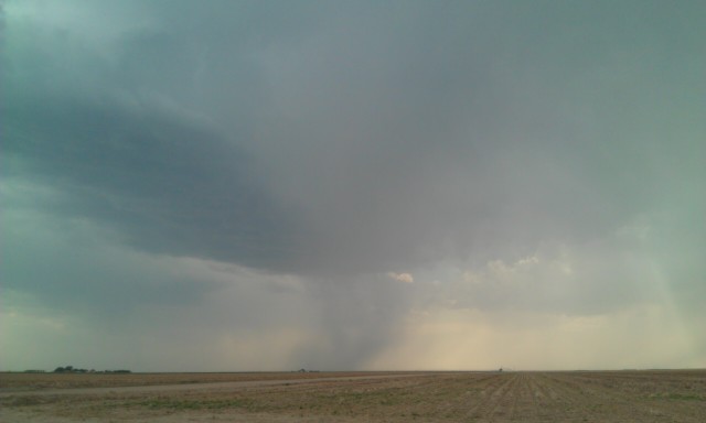
Fri, 03 Jun 2011 23:18:01 -0500
Storm northwest of Leoti KS 523p
(click on thumbnail for pop-up of larger image)
Fri, 3 Jun 2011 21:44:45 -0500
940pm chase update. another successful day of storm photography in NW Kansas. Supercell structure, rainbow, lightning+windmill. Back to Dodge
Fri, 3 Jun 2011 19:34:37 -0500
730p vchase update. supercell with 80 vil moving toward colby. nice photos so far
Fri, 3 Jun 2011 19:09:41 -0500
706pm chase update: photographing this western storm north of russell springs. It has a dark organized base. may blast east if this one dies
Fri, 3 Jun 2011 18:11:36 -0500
610pm chase update: sitting on hwy 25 north of Leoti taking in the high contrast convective scenes! Tall, narrow precip core with blue sky on horizon.
Fri, 3 Jun 2011 16:46:41 -0500
445pm chase update: first attempt at storm failed W of Scott City. New towers forming behind it. Still a good area here. Patience.
Fri, 3 Jun 2011 15:36:04 -0500
330p chase update. healthy tower/small Cb forming N of syracuse will head N at garden city
Fri, 3 Jun 2011 09:50:54 -0500
Here it is! Pastel-color-full-double-rainbow number twooooo! Exactly 24 hours after an incredible rainbow at sunset near Syracuse, KS, it happened again at Elkhart, KS
(click on thumbnail for pop-up of larger image)
Fri, 3 Jun 2011 09:00:15 -0500
Departing high plains severe thunderstorm in sunset light near Elkhart, KS on June 2, 2011
(click on thumbnail for pop-up of larger image)
Fri, 03 Jun 2011 00:42:17 -0500
Storm south of elkhart KS 755pm
(click on thumbnail for pop-up of larger image)
<< Previous Page
1
2
3
4
5
6
7
8
9
10
11
12
13
14
15
16
17
18
19
20
21
22
23
24
25
26
27
28
29
30
31
32
33
34
35
36
37
38
39
40
41
42
43
44
45
46
47
48
49
50
51
52
53
54
55
56
57
58
59
60
61
62
63
64
65
66
67
68
69
70
71
72
73
74
75
76
77
78
79
80
81
82
83
84
85
86
87
88
89
90
91
92
93
94
95
96
97
98
99
100
101
102
103
104
105
106
107
108
109
110
111
112
113
114
115
116
117
118
119
120
121
122
123
124
125
126
127
128
129
130
131
132
133
134
135
136
137
138
139
140
141
142
143
144
Next Page >>
Top Page