Hey Jon thanks for the updates. Looks like you guys will get in here
during the 6 o'clock hour. Honestly, I haven't had much time to
interrogate the latest model data due to a number of last-minute items
I needed to take care of here at home...including the eradication of a
huge swarm of moths that invaded my garage. There were no less than a
thousands moths in my garage. I kid you not. Of course, I had crap
cluttered and piled in the garage, and the moths were all
hiding/sleeping/whatever in every single little dark nook and cranny.
It was something else. Anyway, I am also on short sleep from last
night with the moths being a huge distraction... but at any rate, I've
remedied the issue, and by the time Jon and Rob get here, I will be
ready for a nice dinner and ready to load up and get the hell outta
Dodge. I talked to Jon earlier this morning about possibly getting a
jump start on the Sunday chase target by driving north to I-70 this
evening, mainly given the disgusting moth situation I'm dealing with
at home. More later...
...and it shows better convergence along the dry line with wrn OK.
Rob and I are getting ready to leave for Dodge where we will meet up with M
ike to discuss our plans. Mitch and Candice are currently near Ft.
Worth.
Day 1 is a down day as Rob and I drive to meet up with Mike. Mitch
and Candice have already started their northward trek. They are sti
ll considering a southern target for tomorrow while Mike Rob and I wi
ll be farther north. The 12Z NAM continues to give us multiple opti
ons including one in NW KS ahead of the developing surface low. The
most likely target remains in wrn NE to as far north as extreme swrn SD.&n
bsp Strong moisture advection beginning today will allow a plume of 60-6
5F dewpoints and 3000K+ CAPE to cover the region. There is decent 5
00 mb flow aloft but I'm intrigued to see where the pockets of 850 mb wi
nd end up residing. Wherever the strong crossover between 850 and 5
00 is in wrn NE may end up being the play as long as there is something
trigger storm initiation.
On another note the 12Z NAM does introd
uce something to keep our eyes on in south-central KS. It's a long
shot and likely capped (as the NAM fails to break out any precip) but a
small area between Medicine Lodge and Wichita shows strong sfc convergence
and plenty of flow aloft to make things interesting. Time will tell
!
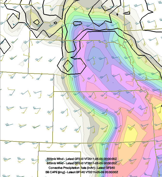
Based on this GFS run (and former runs with ECMWF support as well), it
appears the best area Sunday will be across the Nebraska Sandhills region,
perhaps as far south as I-80.
Based on this GFS run (and former runs with ECMWF support as well), it
appears the best area Sunday will be across the Nebraska Sandhills
region, perhaps as far south as I-80.
It looks like I will be heading north into western Nebraska on Sunday. I
say "I" loosely, because I will most likely be joined by Rob and
Jon and eventually Mitch and Candice. Earlier today the group discussed
the possibility of me being the only one heading north toward the western
Nebraska target for Sunday-Monday. Since Mitch and Candice are driving u
p from Houston, it makes perfect sense that they would have a southern chas
e target bias for Sunday and Monday along the dryline centered roughly arou
nd the Red River region. Rob and Jon will be starting in Kansas City and
Saturday will likely drive down toward Dodge to meet up with me. It app
ears likely that Rob and Jon will join me in my Jeep with Jon leaving his v
ehicle in Dodge. Meanwhile, Mitch and his wife Candice will probably cha
se separate from us Sunday and Monday if Jon and Rob decide to head north i
nto Nebraska with me.
I really like western Nebraska both Sunday and even Monday. Monday c
ould be an extremely dynamic day over northwestern Nebraska at the nose of
the incoming cyclonically-curved jet streak. An east-west axis of CAPE w
ill extend all the way back toward Harrison-Chadron, NE on Monday right at
the nose of this jet and just north of a deepening 990mb surface low. Af
ter Monday's chase, I/we would likely have to bust ass to get back towa
rd the dryline for what appears to be a fairly fruitful day along the dryli
ne south of the front from central KS all the way into north/central Texas.
Tuesday and Wednesday both look like good dryline days. More later..
-Mike U
Thanks for going in and looking at it Mike. I'm basically in agr
eement that the southern play looks best as of today. Saturday look
s extremely marginal but days like that can lead to surprises. W
hile the GFS does a little better on the moisture return Sun-Tues the up
per flow remains shunted to the west. The days where it might be re
asonable offer very little in the way of low-mid level winds. So
I would also focus on north Texas while always keeping an eye peeled to th
e north in case the northern target comes together for certain supercells o
n a certain day.
I went into the office (WFO Dodge City) to interrogate the ECMWF since
that's the only way I can get a look at more fields since they aren't
available on the internet. After looking at this more, I am swaying
more toward the southern scenario... as in go south Saturday... and
stay south for the duration of this good pattern. The upper low is
slower to move out in the ECMWF and latest GFS solutions. The best
forcing and dynamics will be too far west, I think, Sunday and Monday,
and the exit region of the northern jet ahead of the low will be
cofined wayyyy to the north over eastern Wyoming and Montana. This is
not good and will effectively spread the cap northward quite a
ways....into the cooler surface airmass that will not budge. There is
also a sharp gradient in upper level wind speeds with crappy upper
tropospheric flow over Nebraska and points north...with the greatest
flow over eastern Wyoming and Montana. If this were mid to late June,
this would be great for eastern Wyoming/Montana and western Dakotas
chasing, but it is early/mid May and it is still fairly cool up there
and quality moisture just won't make it that far northwest.
This leaves the southern solution. There are a lot of pros for the
southern scenario. 1) Quasi-stationary dryline position day after
day Saturday through Tuesday with southern branch jet spreading
northeast across Texas. Hot surface temperatures and dryline
convergence should help alleviate concerns of initiation, but there
will likely be at least one of these days that will probably cap bust.
Wednesday May 11 looks to be the big day with the main trough/jet
coming out nosing into southern Kansas/Oklahoma. The GFS is faster
suggesting Tuesday would be the most active day (most numerous
storms).
ECMWF dailies:
Saturday -- weak 999mb surface low with convergence max 00z near
Childress with ~ 2500 J/kg CAPE nearby. No QPF being generated.
Sunday -- stronger low level momentum with dryline convergence from
roughly Enid south to Abilene TX. 2500-3000 J/kg CAPE all along
dryline, but CAPE drops off toward central TX. QPF being generated
Red River south to Abilene TX
Monday -- very similar to Sunday...dryline convergence roughly Enid to
Abilene, but may see some moisture mixout farther south toward central
TX... 35-40 knots at 500mb...250mb flow stronger in TX ~ 60-65 knots
weaker toward northern OK/KS around 35 knots. No QPF being generated
anywhere along dryline.
Tuesday -- Same song, third verse. QPF being generated at nose of
southern branch way down near Uvalde, TX (one of our favorites!) and
also in western OK... 2500-3000 J/kg CAPE from Del Rio, TX all the way
into IA.
Wednesday -- The big day in the ECMWF. All sorts of QPF being
generated along dryline/Pacific cold front from southern South Dakota
all the way into southern Texas.
Thursday -- Play scraps in Texas somewhere?
Bottom line is for Sunday and Monday, I am not really in favor of the
weak flow between the two jets up north...and best low level
convergence will probably be confined well to the west away from the
best moisture. I'm swaying toward going ALL IN on the dryline
beginning Saturday Childress to Wichita Falls and just staying down in
north Texas (give or take a 100 miles or so) for the duration of this
pattern.
Just
glanced at the 12Z NAM over lunch. Still has the marginal Red River play on
Saturday, but Sunday could be NICE in swrn NE. If the cap was weaker over
nrn OK, that could be considered. Of
course, then there's Mitch's SPS storm again. Finally, there will likely be
a beautiful supercells in the moisture deprived environment in swrn SD. Ta
ke your pick! If this were to verify, I'd be very intrigued by the SW NE op
tion. Keep in mind that I did not
have time to look and the GFS.
-Jon<
/font>
Jonathan S
. Smith, Officer
State Street Global Services
ECMWF showing the 850mb low over western Nebraska with good moisture
streaming in from the southeast 850mb Theta-E ridge nosing into the
the Nebraska/South Dakota border region. This is toward the southern
edge of the northern branch jet (depicted in the other figure).