Mike Umscheid Photography & Storm Chase Blog
* *  Mike Umscheid PHOTOGRAPHY & STORM CHASE BLOG   * *


Navigate Other Shoots (by year)
2020
2019
2018
2017
2016
2015
2014
2013
2012
2011
2010
Navigate Other Shoots (by month)
July 2020
June 2020
May 2020
April 2020
March 2020
February 2020
November 2019
September 2019
August 2019
July 2019
June 2019
May 2019
April 2019
February 2019
September 2018
August 2018
July 2018
June 2018
May 2018
April 2018
March 2018
February 2018
January 2018
December 2017
November 2017
October 2017
September 2017
August 2017
July 2017
June 2017
May 2017
April 2017
March 2017
February 2017
January 2017
December 2016
November 2016
October 2016
August 2016
July 2016
June 2016
May 2016
April 2016
March 2016
February 2016
January 2016
November 2015
October 2015
August 2015
July 2015
June 2015
May 2015
April 2015
February 2015
January 2015
December 2014
November 2014
October 2014
September 2014
August 2014
July 2014
June 2014
May 2014
April 2014
March 2014
February 2014
January 2014
December 2013
November 2013
October 2013
September 2013
August 2013
July 2013
June 2013
May 2013
April 2013
March 2013
February 2013
January 2013
December 2012
November 2012
October 2012
September 2012
August 2012
July 2012
June 2012
May 2012
April 2012
March 2012
February 2012
December 2011
October 2011
August 2011
July 2011
June 2011
May 2011
April 2011
June 2010
May 2010
April 2010
February 2010
January 2010

<<  Previous Page        Next Page  >>    Top Page

Mon, 17 Jun 2013 22:19:26 -0500
Storm structure and lightning with scenic foreground just north of Hamlet, NE
Atwood, KS HP Supercell Summary & Images (part 5)
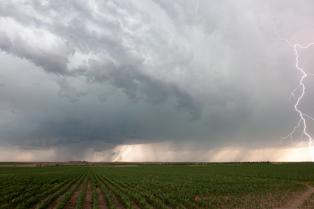
The storm continued to exhibit non-supercell characteristics as it rolled south-southeast at 5:00pm. We found this nice scenic view on Hamlet Road just north of Hamlet, NE (40.411666, -101.223078) as we continued south on county dirt roads. I managed to capture one cloud-to-ground flash, which I cropped to a panoramic 3:1 image as shown here in Image #3

#1

#2

#3

#4
(click on thumbnails for pop-up of larger images)

Mon, 17 Jun 2013 21:53:54 -0500
High-based structure shots as we continue south through western Hayes County, NE
Atwood, KS HP Supercell Summary & Images (part 4)
Time around 4:45pm CDT as we stopped briefly for structure shots looking to the west. The storm was taking on more precipitation in the rear-flank. A tall precipitation shaft was also rather cool to see to the northeast of the aforementioned rear-flank precip. Location west of Hayes Center (40.5107002,-101.2119980)

#1

#2

#3
(click on thumbnails for pop-up of larger images)

Mon, 17 Jun 2013 21:37:01 -0500
Storm taking on more of a linear appearance and less supercellular near Imperial, NE
Atwood, KS HP Supercell Summary & Images (part 3)
This particular stopping location was halfway between Hwy 61 and 25, due east of Imperial, NE (40.5318909,-101.2875977) looking almost due west.  Dual precipitation cores were noted, which provided for some interesting shots.. including a rainfoot on the northern rain shaft.

#1

#2

#3

#4
(click on thumbnails for pop-up of larger images)

Mon, 17 Jun 2013 21:18:04 -0500
Supercell storm moving south-southeast wrapping some rain curtains in high-based circulation
Atwood, KS HP Supercell Summary & Images (part 2)
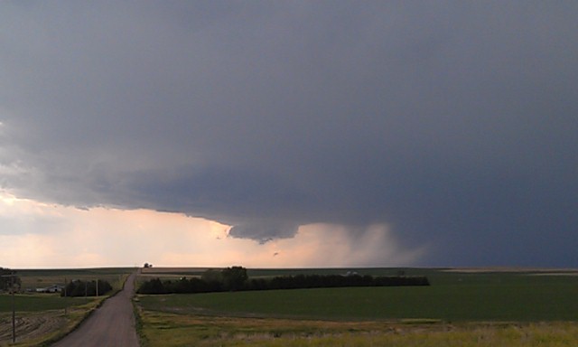
A little bit further south than the previous shooting location (40.6283913,-101.2885971), Jay and I observed the storm wrap some rain curtains in a developing rear-flank downdraft region of the storm. A few attempts at funnel cloud wannabes were observed. Cloud-to-ground lightning was frequent enough in the forward flank downdraft/downshear anvil region of the storm to attempt at some Lightning-trigger shots, with one good frame and one better CG that barely caught the right edge of a frame in another shot.

#1

#2

#3

#4
(click on thumbnails for pop-up of larger images)

Mon, 17 Jun 2013 20:55:02 -0500
High-based supercell undergoing development with wicked scud cloud formation to the west
Atwood, KS HP Supercell Summary & Images (part 1)
This sequence of images was from 3:42pm to 3:57pm CDT looking west from a location about 9 miles south of Highway 23 and 7 miles west of Highway 25 southeast of Grant, Nebraska (40.6985016,-101.2869034). Jay and I found this nice overlook at a county road intersection watching the outflow scud forming at ground level and lifting up into the strong updraft of the developing supercell storm.

#1

#2

#3

#4

#5

#6

#7

#8

#9

#10

#11
(click on thumbnails for pop-up of larger images)

Mon, 17 Jun 2013 00:32:17 -0500
-The Atwood Storm- An ominous high-precipitation severe storm approaching near the town of Atwood, KS on 16 June 2013
  
(click on thumbnail for pop-up of larger image)

Sun, 16 Jun 2013 15:38:34 -0500
High based wall cloud developing supercell near Grant Nebraska
  
(click on thumbnail for pop-up of larger image)

Sat, 15 Jun 2013 23:20:58 -0600
Lightning flash from a diminishing storm southwest of Sterling, CO after sunset 15 June 2013
  
(click on thumbnail for pop-up of larger image)

Sat, 15 Jun 2013 15:23:48 -0600
Storm organizing a nice dark base NW of Cheyenne!
  
(click on thumbnail for pop-up of larger image)

Fri, 14 Jun 2013 22:04:10 -0600
West Point, NE Supercell of 14 June 2013
Awesome supercell structure looking west-northwest near West Point, NE...
The storm never produced a tornado, despite the significant amount of
rotation. This shot is handheld from in the car as a substantial amount of
anvil lightning was occuring very close to me. Not too long after this
image, the structure of the storm started to wane as storms to the south
merged with the supercell... ultimately leading to its demise.
  
(click on thumbnail for pop-up of larger image)

<<  Previous Page        Next Page  >>    Top Page