It is frustrating that slow moving storms are thriving in scenic
terrain northwest of Clayton right over the mesas. I knew that was
going to be an area of nice storms, yet it wasn't my primary target,
and as such, I departed later from home. Another nice storm east of
Las Vegas, NM right where I thought as well. Yet I am here south of
Lamar a little west of my original target. There is 55 dewpoint
inflow air into the storm per springfield and lamar obs... Keep being
patient I guess.
Difficult forecast today. I don't think the moisture farther south is
all that terribly deep, considering the mix out of moisture to varying
degrees depending on your model flavor. That being said, even the
most mixed-out moisture solution would still favor a photogenic
high-based supercell on the high plains of eastern CO/northeastern
NM/western KS. There are two areas I am watching right now. One is a
north-south convergence line that seems to be holding on (so far)
right along the KS-CO border (SW winds at springfield co, kenton ok,
clayton nm vs. SSE winds at elkhart-johnson-syracuse, ks). If this
convergence line holds through mid afternoon, this will be a focus for
initiation. Otherwise, will have my eye farther west for terrain help
along the CO/NM border along the Raton ridge southern Las Animas
County. I will likely head to Johnson, KS in the next hour or two.
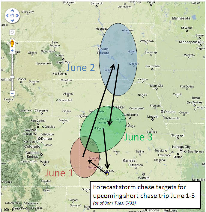
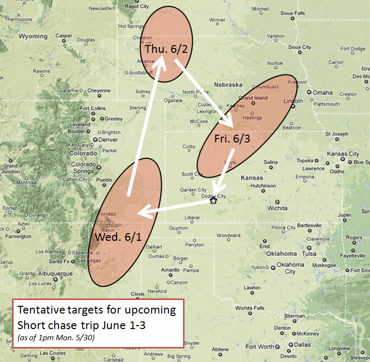
My short storm chase trip for June 1-3 is still a go. This will be a
solo trip, and given the possibility for a long drive during this
trip, I've prepared for "car camping" during this trip to save a
little bit of money given the gas prices. This will also give me the
flexibility to sleep whenever I wish (except for the evening hours of
course!) since my body clock will still be in "midnight shift" mode
for the most part since my last shift is overnight tonight.
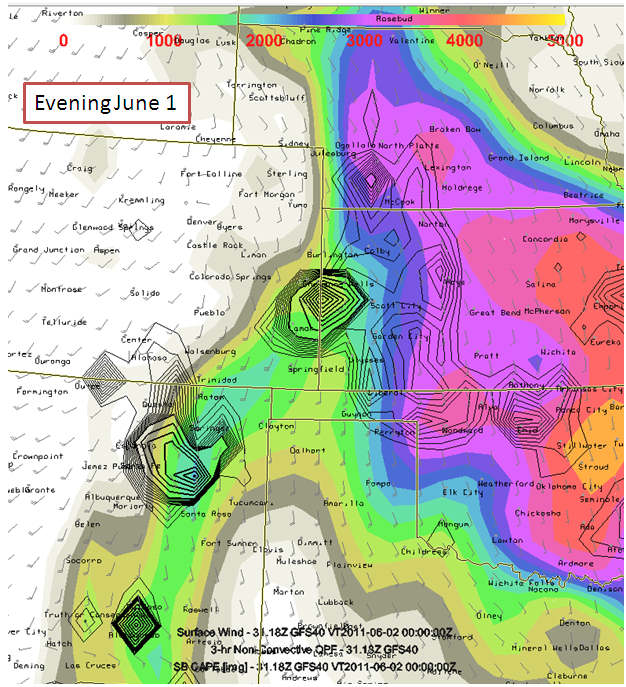
June 1: Target is actually fairly close to home, which sill give me
an opportunity to sleep at least a little bit when I get off work at
6am. Good moisture is coming back into western Kansas tomorrow which
will yield about 2000 to 2500 J/kg of SBCAPE. A minor shortwave
disturbance will move across the Rockies nosing into western Kansas
which will likely aid in storm development near the Colorado-Kansas
Border. Target around Tribune, KS.
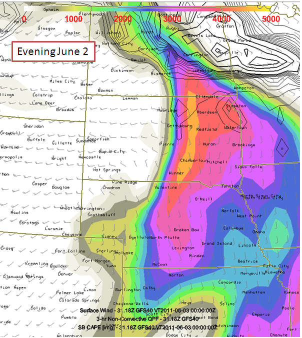
June 2: After the chase is done June 1, I will likely begin my drive
north to South Dakota, which appears to look quite good if a storm can
develop (which I think one will). It will be a long drive, so if it
cap busts... it will be a frustrating and EXPENSIVE one. I am taking
a risk that it WILL break, and I have confidence that it will. If
later model runs of the GFS show more of a potential for a cap bust
versus not... then I will scrub June 2nd chase up that far north. The
Instability and shear will be excellent with classic 50 knots
southwest flow coming into South Dakota at 500mb. Tentative target
Kennebec to Selby, South dakota
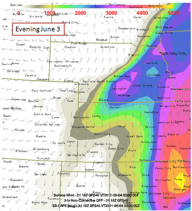
June 3: The front associated with the initial jet streak late June
2nd will move south into Nebraska. The front will slow down and
perhaps stall out in southern Nebraska with 60s dewpoints as far west
as southwestern Nebraska. Tentative target McCook to Lexington, NE.
I will drive back to Dodge City following this chase arriving home
late night, more than likely. I am due back to work Saturday morning
the 4th.
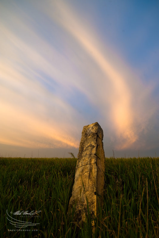
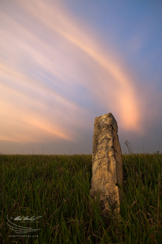
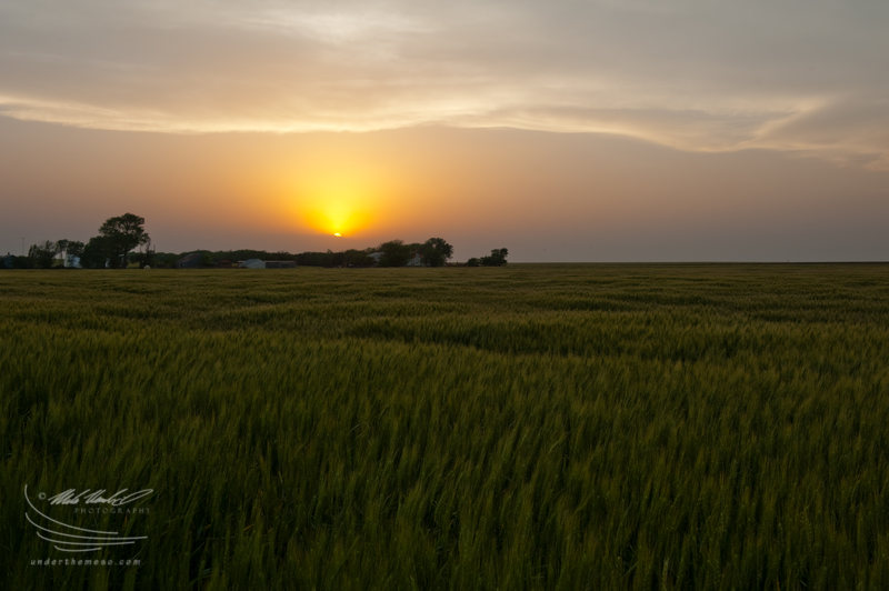
The highlight of this shoot was actually totally unplanned and
spontaneous. Just after leaving the scene where I shot the sunset
from...no more than about a half mile drive back south... I came
across some limestone fence posts along one of the wheat fields north
of Otis. The eastern sky was actually becoming more dramatic with
some of the virga streaks lighting up in pink and orange hues. I went
to work using one of the post rocks as a subject in some of the shots
scene below:
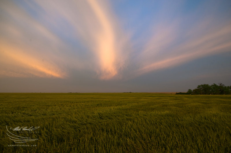
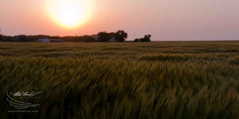
I was hoping for good sunset light to illuminate the under side of the
remnant anvil of the storms that were moving northeast into northern
Kansas. Unfortunately there was no remnant mammatus to speak of, but
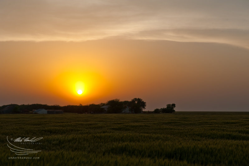
the sunset was still quite impressive. I found a wheat field just
north of Otis, KS to shoot some sunset scenes from. The western
horizon had some smoke and dust in the atmosphere which provided for a
rather red sunset:
A couple of images of the actual storms on this chase... including a
small LP updraft that formed just northeast of the Big Basin Prairie
Preserve south of Minneola and mammatus south of a marginally severe
storm in Rush County, KS:
After my last midnight shift early Wednesday morning (June 1), I am
free to roam the western and central plains until I am due back to
work Saturday morning (June 4), and the overall pattern is favorable
for storms to chase each day. Moisture will return to the high plains
late Tuesday and early Wednesday. I have really liked the looks of
northeastern New Mexico east of the Sangres (Las Vegas, NM northeast
to Clayton) for several days now. After that, though, eastern New
Mexico will likely dry back up from a severe storms standpoint and I
will have to shift my attention back to the north. The threat area
Wednesday may include east-central CO and far western KS. The
300-500mb jet core will overspread the central Rockies and northern
High Plains Thursday -- and on paper this looks to be the best day of
the three of this short trip. I am tentatively thinking about the
northwestern Nebraska area near the South Dakota border east/southeast
of the Black Hills, but I may end up heading all the way up into
central/northern South Dakota where even higher CAPE will exist > 4000
J/kg more than likely with 45-50 knots 500mb flow out of the
southwest. Thursday could be a very good day for the Dakotas. The
front then moves south late Thursday Night and Friday pushing the
focus for storms back into the central Plains. By late day Friday,
the front will probably be positioned across southern Nebraska or even
farther south toward Northwest/north-central Kansas... which is good
as this would be a shorter drive back to Dodge to conclude this trip.
More later.