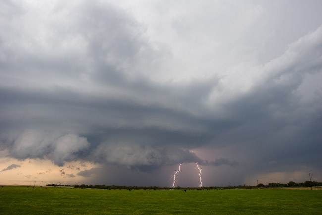
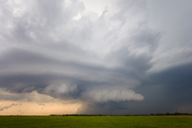
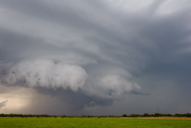
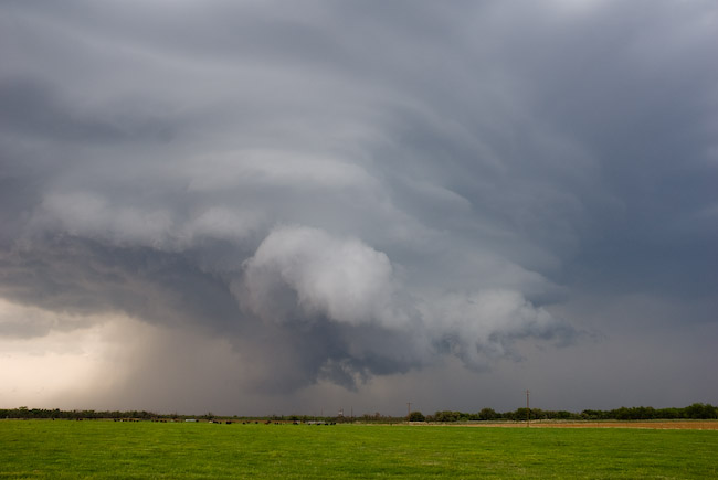
June 5 will be the first of a 3-day weekend chase with my friend Robin Lorenson. I met up with her this evening in Salina and we will depart at around 8:00am heading west on I-70 to Burlington then likely north toward our mid-late afternoon target of Sidney to Sterling. It looks like a fantastic setup for supercell thunderstorms with at least mid 50s dewpoints advecting west-northwestward toward the Cheyenne Ridge. Elevated heating and orographic lift with east-southeast winds will be more than sufficient to aid in thunderstorm development. CAPE will likely exceed 2000 J/kg downstream of the high-terrain development, and the plan is to intercept storms as they develop/coalesce into supercell structures sometime around or after 21-22z… at least that’s the plan! There could be quality chasing/photography well into the evening so a late night may be in order. We will likely settle for the night somewhere along I-76 or I-80. Saturday, June 6 chase area will likely setup in the same general area, perhaps a shade farther east or northeast along I-80 corridor. Sunday could be yet another good day in broad southwest flow aloft around western Nebraska or northeast Colorado. The surface front farther southeast could be another potential play, which would be much closer to central Kansas where we would have to end up at the end of Sunday’s chase.
and do not necessarily represent those of official National Weather Service forecast products,
therefore read and enjoy at your own risk and edification!"
June 4, 2009
May 27, 2009
Chase Acct: May 25, 2009 (KS/CO Border)
May 25, 2009 Tribune, KS Vicinity Storms & Brief Glimpse of a Non-Supercell Tornado
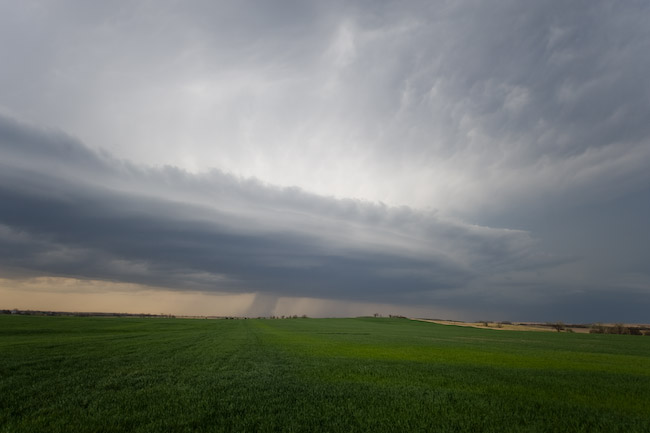
I decided to chase this day with the hopes of intercepting a non-supercell (landspout) tornado along a nearly stationary north-south surface boundary. Surface temperature/dewpoints were expected to be in the mid 70s over mid 50s dewpoints in the area of interest which Lamar, CO to Tribune, KS. I set off from Dodge City at 9:45am (CDT) after a whopping 1.5 hours of sleep following a midnight shift, hopefully arriving in the target area around Noon. I knew that storms would form very early given a non-existent cap. The trick was to get on storms early in their updraft-dominant phase before evolving more upscale into a more complicated outflow dominant mess. The first storms of the day developed along a north-south axis from near Burlington to Cheyenne Wells, and I hoped to reach the southern end of this first development near Cheyenne Wells. I arrived in Cheyenne Wells to a signficantly weakened storm. I didn’t hang around Cheyenne Wells long before realizing I needed to get back southeast toward newly developing sharp-looking towers — about halfway between Cheyenne Wells and Tribune very near the state border.
I decided to head east on an unpaved, but well graded farm road northeast of Sheridan Lake, CO. The newly formed updrafts had high bases to the east and northeast. Eventually the northern one filled in with precipitation, but I continued to trudge east. I stopped for a short time to photograph the darkening mass off to the northeast with an interesting embedded updraft base feature. I photographed this with some oil wells in the foreground very near the state border at around or shortly before 2pm CDT. After this, I continued east on the farm road to get closer to the more southern updraft area of newer cells, but the road became increasingly soft and messy, so I turned around and retreated back west. I eventually headed back south to Towner, CO and then east on Hwy 96 into Greeley County, KS. At this point, I was getting increasingly tired and impatient with the disorganization of everything, so I decided to just bag the chase and head back home so I could get some sleep. Well, as I was writing this off, a new updraft surge was looking rather interesting to my north as I was approaching Tribune. Sometime between 2:30 and 2:40pm CDT, the updraft base to the north looked rather well organized, and I could make out a fairly well-defined high-based funnel cloud. It was such a small funnel relative to the distance from the cloud base to the surface that I just simply wrote it off as an insignificant funnel — however the shape persisted for at least a couple minutes. I was too busy driving to try to get north and closer to the updraft area, so I never stopped to get a photo of this feature. As it turned out, this was actually a landspout tornado that Greely County sherrif confirmed. I got a call from Chris Foltz at WFO Goodland seeking confirmation of this event (as he noticed my position on Spotter Network). I did not confirm a tornado from this feature, but did advise him that I observed what certainly looked to be a legit funnel cloud looking to my north while I was just a few miles west of Tribune.
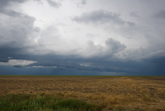
I finally got north of Tribune and no longer observed this funnel cloud. The entire storm base was looking more and more uninteresting with time, so I then backtracked into Tribune. I had thoughts a second time of just heading back home… but then a fairly stout cell formed to my west-southwest, near Sheridan Lake. This storm had a a 50dbz core on radar up to about 25 thousand feet, which was certainly better than most of the other storms I was observing northwest of Tribune up to that point. I could also make out a fairly healthy updraft base and pseudo lowered area way off in the distance. I thought what the hell and decided to head back west on Hwy 96. I didn’t get any farther than about 7 miles west of Tribune before another newly developed storm took my interest south of Tribune to my east-southeast! I just decided to sit still there west of Tribune and watch things for awhile. Storm updraft then began to my northwest at around 3:40pm, and I photographed this for a little bit along Hwy 96. This new storm formed an interesting “mustache” type outflow cloud structure beneath the base which was somewhat photogenic. I then headed north on a farm road just to the north side of Horace where I photographed this storm a little bit more. It was at this point, around 4:15pm CDT, when I met up with the Greeley County sherrif. He described the earlier tornado event to me and described what he saw as a small funnel, a dust debris area in the field, and nothing in the middle — fitting the classic landspout tornado description. He said it lasted some 3 or 4 minutes. After I was done photographing from this location, I finally decided I had enough and began my trek back home.
I reached Garden City at around 6:00pm to a surprisingly well-developed updraft to my east with pretty damn good structure. Instead of taking Hwy 50 back home, I wanted to follow this storm since it looked so appealing visually from the backside. This cell behaved like a left-split supercell, moving to the north-northwest during its brief life as a well-organized storm. I stopped to photograph this updraft a few miles east of Garden City…then decided to get closer to the storm and hopefully either get into some hail or photograph more structure from closer in. By the time I reached about 10 miles northeast of Garden City, the storm rapidly collapsed between 6:30 and 6:45pm. After that, I finally make my final leg back home to Dodge City, in time for about an hour and a half more sleep and my next 10pm-6am shift. All in all, not a fantastic chase photographically speaking, but my forecast verified: There was, indeed, a landspout tornado, however brief it was, northwest of Tribune. I just was not in the right position at the time of the event.


May 16, 2009
Chase Acct [full, part 2/2]: May 1, 2009 (Northwest TX)
Two Mid-Late Evening Supercells: Roby to Anson to Nugent, TX
Here is part 2 of the two-part chase account for May 1st, 2009. After the Rule to Stamford supercell dissipated, I remained in Jones County near Lueders watching struggling towering cumulus to my immediate north and northwest {2342}. The towers showed very little sign of doing anything other than tilting severely to the east in the strong shear, and I really did not expect this localized area of towering cu to do much. After watching a clumping cumulus field on visible satellite continue to grow to my west toward Rotan and Hamlin, I decided to head in that direction. I did like this area due to the fact that it was A) still far enough south of the surging cold front and B) mid 60s dewpoints lurked southeast of the development in the Abilene area. I stopped to refuel in Anson and continued on my way west on Hwy 180 {0009}. There was an east-west line of somewhat aggressive towering cumulus growth with echoes showing up on radar. My plan, obviously, was to target the best of these initial pulses, but my eyes were most set on the western-most of this small area to the north of Roby, near Rotan. There was another storm to the northwest of Rotan, southwest of Jayton, however it appeared to be too far north, too close to the front, and given its east to northeast storm motion, this was not a viable option for a target storm. I did reach Roby and noticed the electrical activity increasing to my north. About this time, radar on Stormlab was showing continued growth of this new storm with a hail icon by 7:32pm {0032}. I decided to drift north of Roby about a mile or so and stop there to photograph {0043). This was a good decision as the storm developed very nicely before my very eyes to my north-northeast.
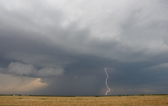
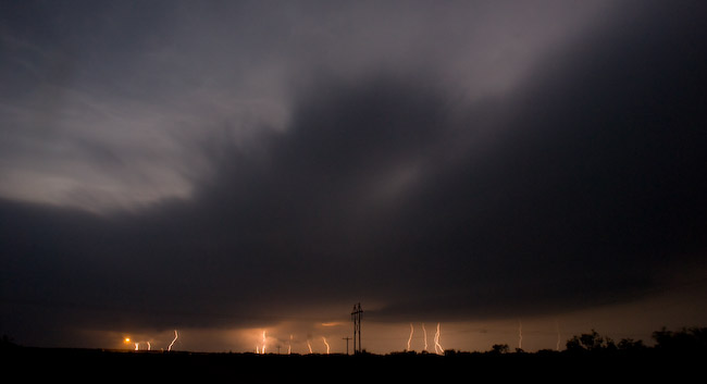
Cloud-to-ground (CG) lightning was photogenic, both within and just outside a concentrated rain core area beneath the storm. I photographed from that spot for nearly 20 minutes — roughly 7:35 to 7:55pm {0056}. Just before I left the location, the storm began to show much better organization, even taking on some supercell structure. I then headed back east on Hwy 180 to follow the storm. Fortunately, it appeared as it right-moved, it would more or less parallel the highway. I stopped again about 5 miles east of Roby along the highway to photograph more. The storm grew into much better structure with striated banding and a mid-level inflow feature on the southeast quadrant {0106}. There was aggressive scud development as well which formed into a wall cloud at times. I set the Nikon D200 on a tripod with the lightning trigger in hopes of capturing a CG with the storm structure. I succeeded. Some cows roaming in the pasture in front of me provided a nice little foreground element addition to the scene. I sat there at that location until a couple minutes before 8:20pm. This would be the best structure this storm would have to offer, for as I continued east…the storm began a slow decrease in intensity as it headed east. All this time, another supercell was developing nicely to my northeast near Haskell {0133}. I stopped one more time to try to photograph dangerous staccato CGs being spit out from my slowly dying storm to the northwest…but the lightning was too close and too dangerous to get out of the vehicle…so after sitting there for a few minutes, I decided to hell with that storm and continued east back to Anson.
By this time, though, it was starting to get dark, and there was no way I’d be able to intercept the new Haskell supercell with any daylight left {0147}. I was still going to follow this storm, though, since it was an extremely easy intercept, plus I had my eyes set on Abilene for a place to stay for the night. This storm was very electrical off to my northeast and was quite impressive on radar {0201}. A couple of other storm chasers closer to this storm reported low, rotating wall clouds at times east of Stamford. Eventually, as this storm approached Hwy 180, other cells began to develop on the southwest flank and the storm became this giant monstrosity of a storm with an incredible amount of CG lightning (both visually and what I was seeing on the Stormlab display! {0242}). I managed to get some CG stills, but nothing all that jaw-dropping. I had a hard time finding an area to concentrate on since there was so much electrical activity everywhere.. it was quite impressive. There was a lot of lightning upstairs, too, and combined with increasing low cloud cover ahead of the storm, made for an interesting “strobe” effect, although sucky for photography. Eventually, I made it to Hwy 351 where I dropped southwest to get into a better position for the storm, the core of which was still off to my northwest at around 10pm {0300}. The storm re-organized into one coherent “blob” of a supercell with a decent mesocyclone, but the visibility sucked where I was, and the hilly terrain northeast of Abilene didn’t help matters either. I was getting kind of tired at this point, too, so I was becoming increasingly impatient with this storm. About halfway to Abilene on Hwy 351, I lost internet connection, which tested my patience even further {0305, the last upload until I got to Abilene). As the storm got closer, I did notice a few instances where distant lightning revealed what appeared to be a concentrated rain-wrapped area of interest, however the lack of frequent lightning illumination prevent good observations.
At about 10:30pm, I called the San Angelo office and talked to my former WFO-DDC colleague Mike Lacy about the storm, relaying to him my observations. He was telling me the best circulation was somewhere between Hamby and Nugent. At that time, I was just on the outskirts of Abilene, so after hearing of this, I decided to backtrack northeast on Hwy 351 toward Hamby to see what I could find. CG lightning around the area of interest was lacking, and low cloud cover around was not helping me figure this storm out one bit. I felt a light northeast wind and eventually noticed a lot of low scud approaching me. I came to the incorrect conclusion that what I was witnessing was near the area of rotation on radar that Mike was telling me about, and given the northeast wind, thinking this thing was either outflow dominant or undercut by the front, so I was not excited about tornado prospects. I say “incorrect conclusion” for this reason: A tornado DID eventually form about 20 minutes after I made this observation…not more than a few miles northeast of my location on Hwy 351! Since I thought the storm was outflow dominant at the time, I packed it in for the night and headed back to Abilene shortly after 10:30pm. What I was observing at that time around 10:30pm was activity along the rear-flank gust front that was approaching my location. The true area of significant rotation was well back in the occluded portion of the supercell, in an area I just simply couldn’t see given the low clouds around and lack of good lightning illumination. I learned of the ~ 15 minute tornado northeast of Abilene from storm chaser Colt Ray Forney who managed to successfully document the event after 11pm as he was positioned on Ranch Road 604 {0418, after I was already in my motel room in Abilene}. I was totally oblivious to this event even a couple days after it happened! Oh well. The tornado he photographed was somewhat wrapped in rain, however it was a fairly stout looking tornado during its mature stage with a fairly nice rope-out he also managed to photograph in the few lightning flashes that occurred. All in all, this was a fine chase day with a number of keeper images for my portfolio ![]()


May 10, 2009
Chase Acct [full, part 1/2]: May 1, 2009 (Northwest TX)
South-moving afternoon supercell from O’Brien to Rule to Stamford, TX
This is part 1/2 of this chase account… as I observed supercells at two different times during this chase. This account focuses on the O’Brien/Rule/Stamford, TX supercell that developed mid-afternoon west of Knox City around 20z (3pm CDT). I left Dodge City shortly after 8:30am for a target from Vernon to Seymour, TX. The main problem for this chase day was the cold front. Plain and simple. It was moving south at a fairly good clip, and the challenge was to get on a storm far enough south of the cold front such that it would not become severely undercut by the front. It was because of this that I decided to hedge south (Seymour).
I arrived in El Dorado, OK around 1pm with a growing cumulus field just along and ahead of the front. This was a good sign that storms would probably develop over the next couple of hours given the extent of the agitated cumulus field. I was monitoring obs closely and was interested in the near-90 degree air from Paducah to Aspermont. I figured a storm would develop at the nose of this hottest air since the cap would be broken easiest here, so I was closely watching hi-res visible satellite imagery for towering cumulus growth in this area. I arrived in Quanah, TX and was tempted to just head straight south to Benjamin. Given the lack of substantial cumulus growth at that time in the area of Benjamin, I decided to just head southeast instead to Vernon. From Vernon, I headed south on Hwy 183 to Seymour. Along the way, cumulus was continuing to grow across all of this small region from Vernon south to Seymour…and even west toward Benjamin. I arrived in Seymour around 2:40pm, and it was at this point that towering cumulus was most impressive southwest of Benjamin, which was some 45 miles to my west-southwest {1946}. I immediately decided I wanted to target this new growth, so after a quick pit-stop in Seymour, I was on my way southwest on Hwy 277 toward Munday {2007}. Once I reached Munday, I decided to continue west-southwest to Knox City as this development was very slow moving…and whatever movement there was, was almost straight south… so I had to keep heading west.
I reached Knox City with tornado sirens blaring in town, which I found quite interesting given the fact I didn’t see any warning on the storm at that time. I headed south on Hwy 6 to O’Brien which was just a few miles south. When I got to O’Brien I could observe a high-based well-defined nub funnel cloud looking almost due west. I had to keep heading west, and fortunately, Ranch 2229 road was there to go west on from O’Brien, so I took this road out of town and found a stopping point a couple miles west of town. This funnel persisted and continued to stretch to nearly halfway to the surface from cloud base. I had to stop here and get the shots before it dissipated. I managed to get some decent images of this well-defined funnel cloud. For the first minute or so of observation, I just thought it was a funnel, but I eventually noticed a small debris cloud beneath the funnel. The images I took were between 3:39 and 3:41pm {2031}. I feel fortunate to have observed this event before many of the other storm chasers arrived on scene. About a half hour after this time, the “chaser hordes” arrived. Many, many storm chasers arrived on the storm finally — many of which were either staging in Wichita Falls, Vernon, or Seymour — arriving from the northeast {2045}.
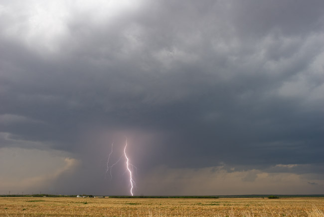
The tornado finally dissipated and it was time to continue south. I did so following county and ranch roads south…to the west of Hwy 6 by about 2 or 3 miles. I stopped intermittently to shoot structure shots. The structure evolved into a classic soda-can supercell updraft with a small lowered wall cloud in the center. The whole storm was rather high-based, so if it was going to produce another tornado (a more classic supercell tornado) I was thinking it would have to do it fairly quick because of the high-based nature and potential forward flank downdraft undercutting problems in its not-too-distant future. I finally reached the town of Rule and regained internet access after about a 45-minute downtime from west of Rochester to Rule {2127}. It was at this point that I began to leap-frog a lot of storm chasers on Hwy 6, once I finally reached this highway. I stopped for a little bit along Hwy 6 south of Rule and watched a beautiful rear-flank downdraft occlusion develop. A tornado cyclone circulation was evident with fairly tight rotation in the wall cloud at around 4:40pm looking to the north-northwest from a few miles south of Rule {2131}. My next stopping location was along a farm road about a half mile east of Hwy 6 where I setup my Nikon D200 on a tripod with the lightning trigger. I managed to get one good cloud-to-ground (CG) lightning image within the supercell core looking to the north. By this time, a rear-flank downdraft surge was heading my way and it was time to bail south. Hwy 6 then turned southeast toward Stamford, and I followed this a few miles southeast to a stopping location to observe the next interesting aspect of this storm. A rather rapidly rotating wall cloud developed to the north with some small dusty spin-ups beneath it initially. Some storm chasers claim a brief ~ 30 second tornado here with this feature based on their accounts, but I am uncertain, because immediately after this, a huge surge of dust was kicked up in the next rear-flank downdraft surge…which was actually quite dynamic to photograph. The copper color of the dust contrasted well against the storm structure from my vantage point. This whole sequence occurred between roughly 5:26 and 5:32pm {2227}.
I then drove through a dusty town of Stamford shortly after shooting the previous scene just northwest of town. The storm was on the demise after that point. I continued southeast then east on some county roads to follow the now decaying storm. My last images of this storm were around 5:53pm looking northeast at a small saucer-shaped updraft base with a neat looking wall cloud as the whole thing was beginning to shrivel up and die {2251}. Now what to do. There was another supercell well to the north-northeast of me approaching the Seymour area from the northwest. The chaser hordes went after this, and it was funny watching all the chasers taking the same route to this storm at around 6pm or so {2309}. Me, on the other hand, I’m not a follower. I stayed put. Small updrafts tried to form near and over me between Stamford and Lueders along Hwy 6, but none of these small updrafts made it very far at all and ultimately bit the dust. I looked at visible satellite and noticed that the best looking clumping cumulus was off to my west still. This interested me because it was still just far enough south of the cold front and there were mid to upper 60s dewpoints not too far southeast of this area. This was my new area of interest: Roby to Rotan, TX (Fisher County). Not following the chaser hordes turned out to be a very wise decision: My new target exploded into supercells and the storm the hordes went after ultimately died when they all arrived on scene! See part 2 of this chase account.


May 3, 2009
Chase Acct: May 2, 2009 (NM-TX Border)
My decision to chase the unconventional target paid off yet again, however my tactical decisions in the field cost me the potential for much better shots of the high-based marginal supercell structure, as I know it had a beautiful high-based saucer shape if I was just positioned farther southeast when I still had light. My target was Hobbs, NM — I had lunch there and hung out in and around town for the better part of the afternoon up until at least 5:30pm or so (CDT). All these crappy virga showers kept forming in my target — but I have learned in the past that on the high plains…sometimes virga showers with high bases turn into something much better if you are patient. Patience was really trying me, and the southernmost grouping of virga showers and high, flat bases was located northeast of Carlsbad, so I made a trek southwest from Hobbs in that direction. I drove about 50 miles southwest of Hobbs and watched a group of really high bases struggle mightily. This area, in retrospect, was too close to the hot, dry air that was impinging on the Carlsbad area. After sitting there along highway 62, the action area was finally developing off to my northeast… just north of Hobbs! I guess I wasn’t patient enough. I had to drive back to Hobbs, and eventually the southernmost storm from the small cluster north of Hobbs took on some interesting supercell structure on radar. I was southwest of the main area of interest the whole time, and given the fact I had fallen behind, I had no time to stop for images. I finally managed to stop for some shots after I had lost pretty much all of my light (it was about 9:20pm CDT by this time) about 15 miles south of Seminole, TX. This storm raced off to the east, but I noticed another healthy storm off to my northwest, to the northwest of Seminole, moving in the direction of Seminole. I drove back north into town then went northwest just a few miles outside of town and got some nice staccato lightning images with a gas processing plant as a horizon line subject to the lightning.


May 2, 2009
Chase Forecast: May 2, 2009 (eastern NM)
That’s right. Eastern New Mexico. Why? I had a good day yesterday, so this will be a more relaxed chase… with a target a bit closer to home then, say, Junction, Texas. I have 3 options: 1) Play the front with upper 60s dewpoints ahead of it in questionable chase territory in the Junction-Menard-Llano-Kerrville polygon… probably messy structure given all the moisture… the farther southeast one gets, the less photogenic storms tend to be. I’m a High Plains storm photographer… so going clear down to almost San Antonio to chase storms isn’t exactly my cup of tea. 2). Play storms coming in New Mexico at the nose of the 250mb jet in the narrow return flow region where some upper 40s dewpoints will sneak back up into eastern New Mexico yeilding perhaps up to 1000 J/kg CAPE… but, the high-res models have been showing convective signals approaching the TX-NM line northwest of LBB for several runs… and there will be a lot of upper forcing in this area. 3) Go home. I’m not ready for 3 yet, so I’m playing #2. I’m going to target Ft. Sumner to Portales. Totally unconventional chase play, and I’ll be the only fool out there, but if I keep my expectations low, then it won’t be that big of a bust. We’ll see what happens.
May 1, 2009
Chase Acct [brief]: May 1, 2009 (Northwest TX)
Real brief for now. I intercepted 3 supercells on Friday, May 1st. The first supercell was the mid-late afternoon supercell which formed in Southwestern Knox County to the west of Knox City. I observed a several-minute tornado west of O’Brien as the storm was organizing into a supercell. This occurred around 3:40pm CDT. This storm went on to become largely outflow dominant given its high-based characteristics. Another marginal tornado probably occurred northwest of Stamford later in the storm’s life. It kicked up some amazing red dirt which I got good images of. The storm then died, and instead of joining the hordes to go after the Seymour storm, I loitered around northeastern Jones County. This paid off. I intercepted another photogenic supercell toward sunset near Roby. A third, even more impressive supercell formed after sunset with it becoming dark… in western Haskell County. This storm dropped south-southeast toward Anson and eventually southeastern Jones County northeast of Abilene. The lightning was prolific with this storm… rather amazing. This was a very satisfying chase. The two images below are of the tornado at the beginning of the chase. The 2nd image is a severely contrast-enhanced version of the first, revealing the faint dust column that my Nikon camera picked up on (which I didn’t realize at the time). Timestamp on the image below is 3:41pm CDT. This is looking almost due west from an observing location ~ 2 miles west of O’Brien, TX:

April 30, 2009
Chase Forecast: May 1-2, 2009 (Southern Plains)
Friday and Saturday May 1-2 are my days off and after thinking about it for a couple days, I will be chasing. A fairly aggressive cold front was really worrying me regarding the quality of chaseable supercell thunderstorms, thus resulting in the last-moment decision to go for a 2-day chase. Friday May 1st looks to be perhaps a spectacular supercell day somewhere along the Red River valley, perhaps along the Highway 287 corridor. A target centered around Vernon-Seymour, TX has my eye at this point. There will probably be a dryline/front intersection near here, which is the place to play Friday — right at the nose of the 90+ degree heat intersecting upper 60s to near 70 dewpoints. Below is a forecast sounding from this evening’s 00z run of the NAM model valid 24 hours from now (when a storm should be in progress) for a location near Seymour, TX. The hodograph looks very favorable for supercells to go along with the more than adequate CAPE of 3300-4000 J/kg. This hodograph structure would support slow moving deviant supercell of 10 to 15 knots! I’ll take that any day of the week ![]() This hodograph is not too dissimilar from the hodograph/wind profile of the Garden City/Plymell, KS Supercell just last night (April 29th) which yeilded the incredible "spaceship" supercell and even a few tornadoes.
This hodograph is not too dissimilar from the hodograph/wind profile of the Garden City/Plymell, KS Supercell just last night (April 29th) which yeilded the incredible "spaceship" supercell and even a few tornadoes.

Saturday, May 2. This is a little more problematic, but has the potential to be a very nice surprise somewhere across Southwest TX or adjacent southern New Mexico. I am in favor of playing the area right at the nose of the 300mb jet streak poised to nose right into the Midland, TX area by Saturday evening. The question is how far west moisture can make it. The NAM has been very aggressive with the cold wedge nosing down into West Texas, however my gut feeling is that the NAM is probably a bit overdone, and has backed off on this in the latest run… more in line with the GFS and ECMWF. The ECMWF had me quite excited about Saturday’s prospects when I was looking at it at work earlier today. The forcing will be very good across the Jal, NM to Midland, TX area by early evening Saturday. Even if mid 50s dewpoints can sneak back northwest up to Midland-Seminole, TX then that would be enough given the degree of ascent to help get storms going. The shear profile looks excellent with the west-east oriented jet streak. The "nose of the upper jet" pattern in the upper levels reminds me of my May 9, 2006 chase in the TX Panhandle, where models struggled in the westward advection of moisture by early evening toward the nose of the upper level jet.

48-hr GFS forecast valid 00z 5/3 (7pm CDT May 2nd). 300mb Jet streak (in blue) nosing into southern portions of West Texas.
April 27, 2009
Chase Acct: April 25, 2009 (Northwest OK)
It was a last-minute decision to chase, leaving 4:30pm from Dodge City after working an 8am to 4pm day shift. Since storms would be underway by the time I reached northwest Oklahoma, my thought was just to head to Woodward, getting there by 6:30pm and target a storm by the time I got there. I intercepted a supercell that tracked northeast along the Canadian River valley north of Cheyenne, OK into Dewey county. I sat at a location south of Taloga about 6 to 10 miles along US-18, photographing the storm as it approached. There was another marginal supercell just northeast of the main storm which was fairly photogenic at times as well. On my way home at around 10:00pm or so, I managed to photograph some impressive staccato lightning. I have included 8 images below. A more detailed account will be forthcoming on this blog post soon.
(edit 5/19, 11:55pm CDT):
Full account:
April 25, 2009: Roll-Camargo-Taloga, OK Evening Supercell & Woodward, OK Staccato Lightning
25 April 2009 had the makings of a potentially impressive mid-late evening tornado event across western Oklahoma as a strong front was expected to stall by late afternoon from the TX Panhandle northeast into northwestern OK. The front was then expected to lift back north as a warm front by early-mid evening with a very impressive low level jet expected to develop by 8:00pm CDT or so. I was working the day shift on the 25th, and since no storms were expected across southwestern KS, I was able to get off work right at 4:00pm. All along, I had no intention of chasing this day, but a last-moment decision was made to go ahead and go after this event. In some ways, this reminded me of the 9 May 2003 chase I had in central OK — a day in which I also departed Dodge City rather late in the afternoon following a day shift.
Storms were going to be underway by the time I reached northwest OK, and my plan was just to head to Woodward then target a storm upon reaching town. I was expecting to reach Woodward by 6:30pm, which would give me a good hour and a half of decent light. There were numerous storms to my east through southeast through south by 6:30pm or so upon my arrival to Woodward {2333}. Given the storm motions, it was a lot easier to incercept storms to my south or south-southwest then anything east of me. Hwy 270 (the “Northwest Passage”) goes southeast from Woodward, which would make life very easy for me from a positioning standpoint. The most interesting storm by the time I reached Woodward was a storm along the Canadian river valley to my south-southwest, near Roll. There were many chasers on this storm, per SpotterNetwork icons. In fact, by 6:42pm {2342}, the storm west of Roll was tornado-warned. This was by far the easiest intercept for me, assuming that no additional storms took over between now and the time I could reach this area. As the Roll storm headed east-northeast, I headed southeast on Hwy 270 from Woodward {0004}. Another storm developed northeast of the primary Roll storm, off to my south-southeast. When I reached Mutual, the sky was getting quite dark, and I could begin to make out a rain-free base well off to my southwest as I continued southeast closer to Seiling {0031}. I stopped briefly to watch this, however I figured I needed to continue south to get into better position of not only this, but the larger storm farther southwest.
I headed south on Hwy 183 through Taloga, ultimately stopping at what would be my primary stopping place, a few miles south of Taloga, until darkness set in. I was in a very good position here {0044}, able to monitor both the storm to my northwest and west-southwest. Both storms had radar rotation. I was near the Canadian River, and the rolling hills/terrain in this area is quite scenic. The high spot I found a few miles south of Taloga suited me well and I did not feel like I needed to move from this spot… just letting the westernmost storm approach me. It was a battle against time, though, as darkness was really beginning to set in after 8:00pm. I managed to get a few cloud-to-ground (CG) images from the northern storm with my lightning trigger on the Nikon D200. The western storm was getting closer, and was revealing a nice lowered area beneath the rain-free base. I was getting rather excited about the prospects of a tornado in the not-too-distant future given the inflow winds I was experiencing, plus the fact the low level jet was expected to be inreasing rather markedly by about this time. There was one problem, though. One big problem. The front was not exactly warm-frontogenetic. It still had cold front characteristics — it was not lifting north. As the storm continued to approach between 8:10 and 8:20pm, it was becoming increasingly clear that it was at least slightly undercut by outflow and/or the front itself. I noticed quite a bit of north-to-south cloud motion with an inflow/outflow interface at the southern edge of the lowered area that was approaching. Nevertheless, this storm had incredible rotation with it, and it still had an opportunity at tornadogenesis if it could deal with only slight undercutting problems. A more compact wall cloud formed at the southern periphery of the rain-free base off to the west at around 8:25pm {0124}. I managed to get a number of decent images of this feature, and I picked a good location to shoot from with a windmill sitting right in front of me. There was just a brief moment between 8:25 and 8:30pm where I thought tornadogenesis was imminent, but that did not last long. A massive amount of precipitation was about to wrap around the southern edge of the circulation obscuring my view (as of the impending darkness was enough of a problem). It wasn’t long before the whole thing was rain-wrapped.
I stayed at that location until about 8:35pm, and then I continued back to the north approaching Taloga. I wanted to get a few more long-exposure structure images, which I did with some success between about 8:40 {0142} and 8:55pm {0155} or so. It was clear at this point the storm was outflow-dominant given the elongated shelf cloud structure. This was the last I would shoot of this storm, so I waited out the passage of the core to the north before beginning my trek back to Dodge {0213}. I finally headed back north around 9:20pm or so, heading in the direction of Woodward when other storms began to develop in front of me on the highway to the northwest {0244}. Surprisingly, brilliant staccato CGs were occurring in front of me and to the right of the road, so much so that I just had to stop to setup to photograph. I photographed CGs between roughly 10:00 and 10:20pm southeast of Woodward {0302, 0319}. A couple of the staccato CG images from this set were definite keepers, which will be added at some point to my fine-art portfolio. After that, I began my trek home to Dodge, getting home about 1:45am.


April 26, 2009
Chase Acct: April 24, 2009 (KS-NE Border)
I photographed a couple severe thunderstorms, one of which becoming a marginal supercell with striated updraft structure, near the Kansas-Nebraska border from near Belleville, KS points east towards Washington, KS. A more detailed account will be written on this blog post, but for now, here are a few images from the chase:
(edited 5/20/09 at 12:20am CDT):
Full chase account:
April 24, 2009: Cold Front Severe Storms Along Kansas-Nebraska Border (Chester, NE to Mahaska, KS to Hollenberg, KS)
I targeted the Kansas-Nebraska border on 24 April 2009 where I thought the western extent of severe storm development would occur along an advancing cold front. Typically, cold front storms are not exactly photogenic, but I thought I would try my luck. “Tail-end Charlie” storms, regardless of whether they are along a cold front or not, can sometimes be fairly productive from a photography standpoint with at least decent storm structure. I wanted to target the nose of the warmest air, also at the nose of the mid-60s dewpoints that were expected to move up into the area from south-central KS. A look at the forecast hodograph showed a clockwise curved wind profile on the hodograph, which was promosing for perhaps supercell structures. I left Dodge City late in the morning for a target between Belleville, KS and Hebron, NE by 4:00pm or so.
I arrived in Hebron, NE to a clear sky devoid of any cumulus growth at 3:00pm {2001}. Where was the western extent of development going to be? The latest RUC and NAM models seemed to suggest that the western edge would be just a bit east of Hebron, so once cumulus did finally grow along the front to my northeast, I began to head in that direction at about 4:20pm {2126}. I guess part of this decision was based on the fact that after sitting in one place for over an hour, you start to second-guess your target. I drove east to Fairbury, reaching that location at 5:00pm or so. By this time, small storms were beginning to develop — first to the northeast of my location, then north. Once I reached the small community of Harbine, I took a few photos of the initial cumulus congestus growth to my north {2223}. Looking back to the west-southwest, all of a sudden there was fairly substantial towering cumulus growth in that direction…as far west-southwest as the Hwy 81 corridor to the south of Hebron where I was sitting between 3:00 and almost 4:30pm {2236}. I quickly realized that I should have just stayed there, but there was no time to dwell on that — it was time to get back southwest. I decided to take Hwy 8 through Reynolds and Hubbell, NE to get back to my original target. There was fairly aggressive development into a severe thunderstorm between 5:40 and 6:00pm very near the Kansas-Nebraska border southwest of Chester, NE {2300}. The storm was moving to the northeast, which made for a perfect intercept given my location to the northeast of the storm. The problem was, the storm was moving in an unfavorable direction with respect to the cold front. While the storm was moving northeast, the cold front continued to move south, and rapid undercutting was inevitable.
I managed to make it to Hwy 81 at Chester, NE about 10-15 minutes prior to the core making it to the highway, and off to the south I went. I crossed the frontal zone about 5-7 miles to the south of the strongest radar echoes, so this storm was very undercut by the cold front by this time. At the interface, I noticed a few gustnadoes swirling in the farm field to my immediate southwest, but they were extremely short-lived and very weak at that. I called the Topeka NWS office to let them know of this observation. I stopped a few times south of Belleville to get some structure photos between 6:35 and 7:00pm. By 7:00pm, the development to my west was becoming a bit more interesting to my northwest {2356}, although north of the front. I finally headed east on a farm road between Belleville and Agenda, following the eastern storm (there were two storms of interest by this time: one northwest of Belleville and one near Narka {0009}). I liked the overall structure of the Narka storm so I continued to blast east to stay in a somewhat reasonable position. I got back on paved Hwy 148 and continued east toward Agenda. I stopped just east of Agenda to shoot structure to the north, some 20 miles away {0028}. I had to be at this distance to get the structure shots I wanted since the storm was undercut by the cold front. Even though the storm was undercut by the cold front, it still revealed some marginal supercell structure with a somewhat tiered elongated updraft structure. The storm looked less supercellular with time as the structure was becoming more linear in appearance as another cell was forming in the immediate wake of the first. Nevertheless, there was still decent, somewhat photogenic storm structure at sunset as I was positioned southwest of Washington {0105}. I photographed the structure of this elongated activity up until shortly before 8:20pm {0115} when darkness was beginning to set in and the best of the structure was fading. All in all, not too bad of results considering what I was up against (fairly strong cold front causing severe undercutting problems).