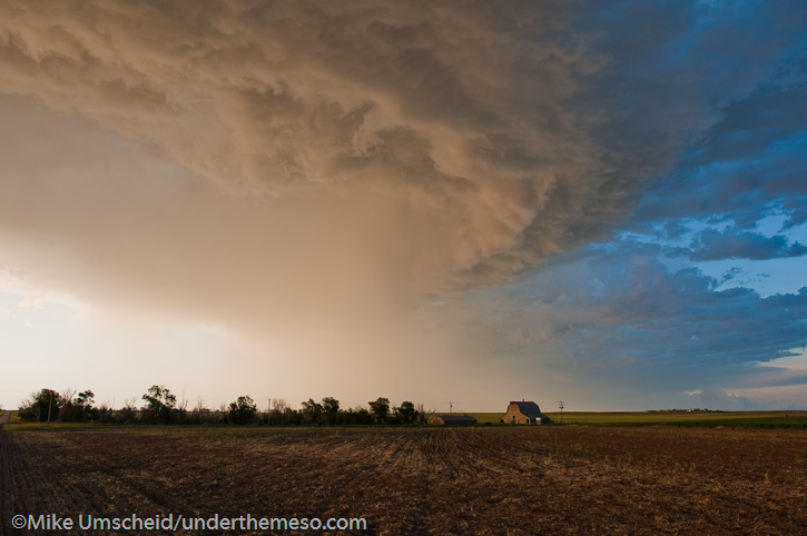
Evan and I intercepted a fairly robust supercell which had its origins north of Cheyenne. This storm moved northeast along the Hwy 85 corridor and was undercut by a fair amount of cool outflow from significant precipitation core to the northeast. A new updraft emerged northeast of the original updraft and we were immediately caught behind and had to reposition. We did so by blasting south to I-80 to Burns, WY then east along I-80 with an incredible view of the supercell cumulonimbus and cumuliform anvil with overturning convection. Even from a distance we could tell that the storm was still riding its own outflow. We drove east all the way to Potter, NE between Kimball and Sidney where we headed north to get closer once we caught up to the southeast side of the storm. We stopped briefly about 7 miles north along Road 77 and photographed the amazing supercell updraft… probably the best supercell structure of the trip so far. The convective overturning at anvil level was simply amazing with a well developed inflow tail to the north. We then drove east on a very dirty farm road and had near-zero visibility in RFD dust as the wind was parallel to the road we were driving. Fortunately, we finally got east of this dust, but by the time we finally reached Hwy 385 near Gurley, the storm was shrinking and becoming less interesting to pursue. We drove down to Sidney and then back west again on I-80 to hopefully photograph some new storms forming northeast of Cheyenne, but north of the outflow boundary. We enjoyed some nice evening photography along a farm road north of Bushnell, NE before we ended the chase and headed to Cheyenne for the night.
Start: Goodland, KS
End: Cheyenne, WY
Day Six mileage: 571 mi.
Chase trip mileage: 3022 mi.


High-based storm & lightning near Grainfield, Kansas

(rest of images at the bottom of this post)
I was not expecting much on this day given dewpoint temperatures in the mid to upper 30s across much of western and central Kansas, however there were going to be storms based simply on the notion that temperatures in the mid levels…500 to 700mb… were still very cold. 500mb temperatures were going to be around -22 to -23C. The problem was that there wasn’t much of a focus for initiation to zero in and target on for chasing. Where was the best storm to photograph going to end up being? The environment looked equal just about everywhere from southwest Kansas into south-central Nebraska. I decided to use the RUC model as my guide as it was showing a corridor of southeast winds with a little bit better moisture… say mid 40s dewpoints… advecting back into west-central Kansas around Ness City perhaps. As it turned out, these winds never really materialized, and winds were quite light everywhere. The first storms developed farther north… north of Hill City, and this is where I was led. I made it to Hill City and eventually Norton, going after some briefly strong storms just into Nebraska near Alma. By the time I reached North I drove east to get into better position of these, but as I was doing this, those storms eventually waned with a bunch of other scattered weak convection developing to my southeast, south and southwest. Where to now? There was no need to be this far northeast when I could be a bit closer to home to photograph essentially the same convection. So I headed back southwest. I followed Hwy 9 west-southwest to Hwy 23 north of Hoxie as this areas was convecting better than any other, so I thought what the heck, I’ll just get closer to this stuff. I went south to Hoxie and eventually Grainfield when the “storm of the day” for me came into view to my southwest.
I wanted to get into a decent position for this cell, so I drove south on an unpaved county road southwest of Grainfield. I stumbled upon my shooting location of choice. A farm field with old corn stalks and an old barn making for a fantastic foreground subject. I used this old barn to my advantage — it certainly made the shoot! I set the D200 up with the lightning trigger and let ‘er go to work while I roamed around with the D3 to get some compositions of this old barn and the storm. I managed to get a few cloud-to-ground images from this storm with the barn off to the right. I think these compositions with the storm, lightning, and old barn work best as 2:1 crops in post-processing, which is what you’ll see in the album of images from this shoot. One of the frames even has me in the shot, which actually kinda works in a way for perspective! I felt pretty satisified with this and decided not to get greedy and begin my way back home. I went south on Hwy 23 to Gove only to find that it was closed south of Gove. I was forced to turn around and head back to I-70, but the next storm that developed in the cluster was producing some decent lightning frequency, so I gave it one more attempt to photograph just northeast of Grainfield this time along Hwy 23. I was at this location for probably 15 or 20 minutes before the lightning activity waned. At that time I decided to finally head on back to Dodge. This was exactly the kind of shoot I was hoping for, but honestly wasn’t expecting. I think one or two of the images from this day are Portfolio-worthy.
Begin: Dodge City, KS (home)
End: Dodge City, KS (home)
Day Nine Mileage: 431 mi.
Trip Mileage: 4085 mi.
13 images from this day’s shoot:
This SimpleViewer gallery requires Macromedia Flash. Please open this post in your browser or get Macromedia Flash
here.
This is a
WPSimpleViewerGallery
update: aborting chase, west winds have totally overwhelmed southwest and now south central KS… this is what I get for waking up at noon and not spending time to actually forecast… and making a knee-jerk reaction to mid-day analysis.. towers are forming just northwest of Wichita, and by the time I reach them, it will likely be 6pm and near Topeka.. plus, I left my hiking shoes at home… I’m going to turn around and go back home, get my hiking shoes and then set off for Palo Duro or Caprock Canyons SP and maybe do some hiking tomorrow. Plus, there’s some convective showers developing in the northern Panhandles, so there might be something to photograph on my way down there
Dumas, TX storm total snowfall of 8″ as of 2:30pm. There are a lot of 18-24″ drifts, too. The tallest drift measured 38″ in front of the Days Inn, it swallowed up my metal yard stick. Snowfall rate will be decreasing slightly through 5pm or so with 3/4″ per hour probably. I think we will squeeze out another 4 inches at least before all is said and done here in Dumas.
Elsewhere, major ice event underway across much of central/southern Oklahoma. Numerous power outages are being reported already and portions of Oklahoma are under a state of emergency. Check out the major precipitation shield engulfing Oklahoma! Here in Dumas, we are now entering the backside of this storm as it begins to occlude, but should remain in the deformation zone so moderate to occasionally heavy snow will continue through at least the mid-evening hours.

2009 will go down as another highly successful year for fine-art storm photography. While I missed out on a number of tornado intercepts, I managed to record some amazing moments of atmospheric violence and beauty. This album showcases the most special moments of storm photography during the 2009 season. I hope you enjoy this series of images as much as I had recording them.
-Mike Umscheid

This post is mainly directed to my Facebook friends. Over the past week or two, I have had spam sent out through my Facebook account on more than one occasion to pretty much everyone on my Friends list.. I apologize for this nonsense.. I have de-activated my Facebook account for the time being until I completely clean up my computers, freeing it of all spyware, trojans, bots, etc. that may exist. I’ll get the mess sorted out over the next couple weeks or so.
On a completely different topic, last night I hit my first Royal Flush on video poker at Ameristar Casino last night. I was out with my bowling teammates as we are in KC this weekend for the Kansas state bowling tournament. I was playing max credit (thank god), but was only on a 10-cent machine, which wasn’t a progressive machine  , so I won $400. I held a "3-to-a-Royal" first hand, and got the last two cards for the Royal. Pretty cool!
Some images from this afternoon’s snowstorm around North Platte, NE:


5.6" officially at North Platte airport. LSR issued by North Platte mentioned 5.6" measured snowfall with this storm as of 8:00pm CDT. That sounds about right. Snow depth is a bit less than that though given the amount of melting through. the day. On the backside of this storm, still seeing moderate snow here in North Platte late in the evening. Will get a few pics uploaded here soon. The plan for me is to leave here very early in the morning so I can make it back to Dodge by late morning/midday Friday.
Not a whole lot of significant excitement to report this afternoon. There has been probably 4-5" of snowFALL around North Platte, but current snowDEPTH is barely 3". I drove around town and photographed some snow scenics around a couple of the city parks here in North Platte. Then I drove northwest of town about 6-8 miles or so. The wind started to pick up quite a bit around 3pm, gusting to 40 mph at times. Blowing snow was rather widespread over the open areas and really increased the snowpack over the east-west and southeast-northwest oriented roads. Some near-blizzard conditions were experienced at times. I am back at the motel room now, as it is still snowing moderately out there. It sure looks like north of here into the Sandhills got the most snow based on radar data. Later on this evening I’ll post a few pics.


