High Plains Drifter


disclaimer:  "The meteorological views/forecast thinking expressed are those solely of the author of this blog
and do not necessarily represent those of official National Weather Service forecast products,
therefore read and enjoy at your own risk and edification!"

November 30, 2007

Great Plains Winter Storm Dec 1 [post 6]

Filed under: General Weather & Forecasting — Mike U @ 9:31 pm

The dreaded Rain Shadow.  This post will be real brief.  I’m not liking the new QPF trends from the numerical models for Dodge City and the rest of western Kansas.  I attached one image on this post, a 36-hour total precipitation graphic from the NAM model ending 12z (6am) Sunday Dec 2.  We will be completely rain-shadowed from the Pacific moisture, which always happens, given the geography.  The gulf trajectories and the shape of the low level jet do not favor significant precipitation in western Kansas.  Typically, you want to be on the north side of the low level jet, where convergence occurs, to get appreciable precipitation.  This will be way northeast of Southwest Kansas.  I’ll be surprised if there is even .25" of precipitation over any portion of the western 1/3 of Kansas.  There’s nothing on the radar yet, except for in New Mexico as of 930pm CST.  


Great Plains Winter Storm Dec 1 [post 5]

Filed under: General Weather & Forecasting — Mike U @ 4:25 pm

Img 1Still in the 20s!  It’s cloudy and cold right now in Dodge City with the 3pm temperature of 28°F — a far cry from the lower 40s the GFS and NAM had for highs for us just yesterday.  Maybe one of these days, the boundary layer non-hydrostatic physics will improve in the NAM model, and shallow arctic airmasses on the High Plains will be better forecast.  So, it’s colder, and also drier, with a dewpoint in the single digits.  It’s a no-brainer that our precipitation type tonight will be in the form of freezing rain (maybe some sleet mixed in initially).  The question, then, is how much precipitation will we get?  At this point I’m thinking about 0.15" of mainly freezing rain here in Dodge City.  By the time the expansive precipitation area Img 2organized later tonight and into tomorrow morning, the "show" will be lifting rapidly northeast of here.  The two graphics I present in this post are the 21z (3pm CST) surface observations in Img 1 and the 3-hr forecast of surface temperature and wind from the NAM model in Img 2.  As you can see, across pretty much all of western Kansas, the 3-hr forecast (3 hour!!) is off by a significant margin.

Great Plains Winter Storm Dec 1 [post 4]

Filed under: General Weather & Forecasting — Mike U @ 10:52 am

Img 2Models are too warm!  15z (10am CST) surface observation plot (Img 1) shows the arctic cold front surging south into the Texas Panhandle this morning.  Both the GFS and the NAM models are too warm with temperatures behind the front across western Kansas.   The GFS model from the 06z run valid 15z (a 9 hour forecast) was predicting a surface temperature in Dodge City of around 34°F (Img 2), a solid 12 degrees warmer than the actual 15z observation!  The NAM 3-hour forecast from the 12z run was showing about 28°F, or about 6 degrees too warm (Img 3).  In all three images, I drew in (dotted blue line) the 22°F isotherm to better illustrate the error in the models in handling this shallow arctic airmass.

November 29, 2007

Great Plains Winter Storm Dec 1 [post 3]

Filed under: General Weather & Forecasting — Mike U @ 7:08 pm

Thursday evening 11/29 update.  Not a whole lot has changed in the model data today actually.  It still looks like it will be too warm for significant freezing rain, except for north central and northeastern portions of Kansas.  In the DDC NWS forecast area, this would most likely be the Hays-Wakeeney areas.  The day shift Img 1issued a winter storm watch to include as far south as Dodge City.  The surface temperature will have to be a little bit colder than any of the models are suggesting at this point for any freezing precipitation in Dodge, but it has happened many, many times (surface temps colder than any of the 36-48hr progs suggesting).  I’ve included a couple of interesting graphics showing the model depiction of the low level warm air advection with this strong storm.  It is about as impressive of warm air advection as I’ve seen here in the western Plains given the combination of tight temperature gradient + wind magnitude.  The first image (Img 1) is a 30-hour progression of the 850mb pattern (temperature, wind, and height) showing the modified arctic boundary retreating northward on southwest 850mb of 50-60 knots!  In the next image (Img 2), I show the NAM model surface forecast from this morning’s run with temperature, wind, and sea level pressure.  I annotated the front on this image, denoted in the solid redImg 2 (warm front) and red-blue alternate (stationary front).  I also depicted a sort of "secondary" downslope front in a lighter red shading.  I think in this airmass, temperatures will get very mild with very strong winds expected amidst deep mixing.  In Img 2, I annotated  in dotted line roughly the 32°F as forecast by this morning’s NAM model. You can see that the NAM only shows surface freezing temperatures only as far south as about I-70 — with about 35°F or so in Dodge City between midnight and 6am.  Five degrees colder, and of course there could be some problems if there is significant enough precipitation (hence the Winter Storm Watch).  

High Wind Warning Criteria?  Then there is the wind aspect of this storm on Saturday.  Significant cyclogenesis is expected across eastern Colorado on Saturday with a surface low perhaps as deep as 988mb!  The pressure/height gradient up to 700mb will be very tight with 50-70 knots expected from 800-650mb or so.  As mentioned previously, the locations that get into the "downslope" airmass across far Img 3Southwest Kansas in particular, will be susceptible to perhaps 60mph wind gusts!  The third image in this post (Img 3) depicts the GFS forecast 750mb Wind.  The wind speed on the graphic is in knots.  I also overlayed the surface wind on top of the 750mb to get an idea of directional vertical wind shear.  This is important for sufficient "mechanical" mixing.  The less the directional wind shear across the layer, the easier it is for mixing of momentum in the layer, given steep adiabatic (or nearly adiabatic) lapse rates.  Across far Southwest Kansas, the surface wind will likely be veered enough with very little directional shear to 750mb (the area depicted west and south of the dotted red line in Img 3).  Thus, it would be easy for the atmosphere to mix down those 750mb winds in gusts at the surface.  750mb wind speed forecasts for Saturday afternoon are in the 55-60 knot range!  We may be looking at some high wind warning criteria winds across portions of Southwest Kansas Saturday afternoon.  More later.  -Mike U

Great Plains Winter Storm Dec 1 [post 2]

Filed under: General Weather & Forecasting — Mike U @ 4:37 am

Well.. maybe The Weather Channel will be right after all!!  I love this job.  Here I was explaining in my previous post how The Weather Channel’s supposed "rediculous" high in the mid 60s didn’t have much merit given how shallow arctic cold air masses this time of year usually "work" around here…. but there is little support now in the cold air "hanging tough" on Saturday.  I had to update our forecast here at the NWS here in Dodge City for higher temps Saturday.  If there is going to be any freezing rain, it will be during the midnight to 6am time frame early Saturday morning… before the massive warm air advection overtakes the remnant modified arctic airmass. Now, if you lived in, say, Sioux City, Iowa… or anywhere else in Iowa for that matter… get ready for some nice winter precipitation!  -a humbled Mike

November 28, 2007

Great Plains Winter Storm Dec 1 [post 1]

Filed under: General Weather & Forecasting — Mike U @ 6:15 pm

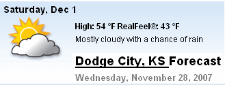
Ice problems Saturday (Dec 1) across portions of Kansas?  It sure looks like this is a plausible scenario.  This is the first post of several, I would imagine, as I have interest in this system from a forecasting standpoint and the complexities of precipitation type forecasting.  Look for official National Weather Service forecasts concerning this system for Southwest Kansas, issued by yours truly, as I’ll be working midnight shifts forecasting for the Fri-Sat time period (Nov 30-Dec 1).  Anyway, the first post about this storm relates to the different forecasts for Saturday, Dec 1st (and oh are they different!) among the Weather Channel, AccuWeather, and the National Weather Service.  Refer to the following images.  The set of images below are forecasts for Saturday in Dodge City from each of the three services:


AccuWeather ^


The Weather Channel ^ 


National Weather Service ^ 

The temperature forecast challenge, as you can see just by comparing these 3 forecasts, is about as great as it gets.  That said, biases aside, I believe the National Weather Service forecast, given local expertise, is the superior forecast, especially considering shallow arctic airmasses.  An arctic front will push through Friday, and numerical models always have a hard time with a) the degree of cold air pushing south and b) scouring the shallow cold airmass out too fast.  This has huge implications, of course, for precipitation type.  Currently, only the National Weather Service is forecasting any possibility of freezing rain.  Neither the Weather Channel nor AccuWeather show any possibility of freezing rain — even for Hays, KS north of here (images not shown, but I have them available!).  This post isn’t to rag on the other weather services, because the storm hasn’t even occurred yet, but I will say that given the lack of local expertise from The Weather Channel and AccuWeather, their High Plains weather forecasts will almost always be inferior to those forecasts from the meteorologists who actually live out here and know the local tendencies, for instance, when shallow arctic air invades in the winter time.  We’ll see what happens, it will be an interesting storm to say the least!  I love forecasting winter weather!  -Mike U

November 23, 2007

First Snow of the Season [post 3]

Filed under: General Weather & Forecasting — Mike U @ 7:51 pm

About 1.5" in the backyard.  It’s still snowing lightly out there during the mid-evening hours.  I went out to the backyard where it appeared there was a more even distribution of the snow cover and came up with about 1.5" or so.  Looks like a lot of areas around here are in the 1-3" range… a fairly even distribution around Southwest Kansas.  So the first 1" of snow has arrived here on November 23rd.  On to bigger and badder snowstorms!!

First Snow of the Season [post 2]

Filed under: General Weather & Forecasting — Mike U @ 1:51 pm

12:25pm.  Moderate Snow… quickly all-white cover! We should be in decent snow for the next couple of hours.  Here are a couple of photos I just took out my front door: 

-repost.  originally posted 12:25pm CST


First Snow of the Season

Filed under: General Weather & Forecasting — Mike U @ 1:49 pm

Around 1-2" expected around Dodge City.

As I type, it has just started snowing, with an initial white cover over the driveway.  The first snow of the season!  Below is a radar image at about the time of this post.  It came in a few hours earlier than I expected, and may also end a little earlier than expected… probably a 6-hour snow event for this area… but at least it’s a start!

-repost.  originally posted  12pm CST


November 1, 2007

Discovery Channel’s “Storm Chasers”

Filed under: Editorial,Storm Chasing — Mike U @ 7:26 pm

Man, it’s been awhile since I’ve blogged!  I guess I just haven’t been in a writing mood recently — alas if it’s not something meteorological related or storm chasing, then I usually do not feel like writing about it.  Like a lot of other avid Discovery Channel (DSC) viewers, I have found the latest "Storm Chasers" series to be quite interesting — the latest in DSC’s "reality show" style of programming that has really grabbed viewers over the past couple years… along the lines of "Deadliest Catch", "Man vs. Wild", "Survivorman", among others — all of which I find very interesting to watch. 

"Storm Chasers" is a 4-part "reality" series that was filmed during a ~6 week period from late April through May 2007.  You can read more about it on DSC’s website.  As a storm chaser myself, it is easy scrutinize or pick at this program with a fine-tooth comb given my familiarity with storm chasing… although not necessarily on the research side of storm chasing — that said, much of the trials and drama that is portrayed in "Storm Chasers" is very much experienced by all storm chasers — research or not.  For this reason, I love the program.  I have not seen one documentary, made-for-teevee movie, theatre movie, etc. that has portrayed what storm chasing really is.  Just about all of "Storm Chasers" is really what you see happen to all storm chasers at some point — we all have to make the same forecast and tactical decisions to achieve our goals of the chase — whether they are research oriented trying to get as close to… or even in a tornado in TIV’s case — or fine-art photography of supercell storm structures like in my case (as you can see throughout my website). 

During their six-week stretch on the Plains, DOW, TIV, and the DSC crew made a visit to the National Weather Service in Dodge City where I work, and I had a chance to visit with Josh, Sean, and the rest of their team.  The DSC crew was interested in interviewing me about the Greensburg storm, for obvious reasons, during their visit.  15-20 seconds of this interview of me was included in episode #3 of "Storm Chasers", about 3/4 towards the end of the show. 

Their "bust" of May 4, 2007, the Greensburg Day, rings very familiar with many storm chasers.  We have all had busts like that.  To me, this was like me re-living the June 12, 2004 "Mulvane" day all over again.  On this particular day, we chased crap storms in an area of north-central Kansas near the Nebraska border where it appeared that supercell storms and tornadoes would thrive.  We actually had two targets that day — a southern target near Medicine Lodge as well… but we (Jay Antle and I) began the day up in Iowa, and we obviously opted for a closer target.  As it turned out, the southern target was the real winner on June 12, 2004 (from a storm chasing standpoint), much like the southern target was as well on May 4, 2007.  Our day ended relatively early in the evening on June 12th, but we were too far away to make it down towards the Wichita area, so a friend of mine I met up with decided to just head down to Salina and drown our sorrows of the chase by heading to the bowling alley to bowl a few games –  this is very similar to Sean Casey and the TIV crew drowning their sorrows at a local bar in Hays, KS on May 4th, 2007.  While at the bowling alley in Salina with my friend Christina that evening of June 12, 2004, there was a television on that we could see, and of course as we would know, they were showing severe weather coverage and video of this incredible, tall, photogenic tornado near Mulvane.  I couldn’t believe what I was seeing, sitting there in that bowling alley on a chase day bust, watching this incredible tornado about 2 hours south of where we were — again, this is very similar to the TIV crew watching the news unfold of the Greensburg disaster at the bar they were at in Hays that night, and seeing the incredible video of the Arnett, OK tornado (what the DSC calls the "Woodward" tornado in episode #3) shot by other storm chasers.  It was eerie how similar their fate was to mine of June 12, 2004.  For those who chase a long time, it happens to all of us.  It’s not easy to swallow.  I think the DSC did a fantastic job of portraying this kind of emotion that can be brought on storm chasers. 

I, for one, am a fan of "Storm Chasers", and even though DSC film crew has taken a lot of flack from the storm chasing community, they have put together a pretty darn good 4-episode series, even despite the limited success the DOW and TIV team hadin the 2007 season.  I think this may have opened it up for another season, as I’ve come across a number of people who have watched this series, and who have really liked what they have seen — in other words, I think there is indeed and audience for "Storm Chasers" like there is for some of the other popular DSC "reality" series — I don’t think many storm chasers will like this, but I do welcome it… it just means I won’t be taking my chase trip in May when the "hordes" are roaming about, but then again, I’m not all about "the tornado", just give me a photogenic supercell late in the season, and I am happy :)

Mike U


Powered by WordPress