High Plains Drifter


disclaimer:  "The meteorological views/forecast thinking expressed are those solely of the author of this blog
and do not necessarily represent those of official National Weather Service forecast products,
therefore read and enjoy at your own risk and edification!"

January 9, 2011

Southwest Kansas Winter Weather Event January 9-10 [post 2]

Filed under: 2011 Jan 10 — Mike U @ 10:09 pm

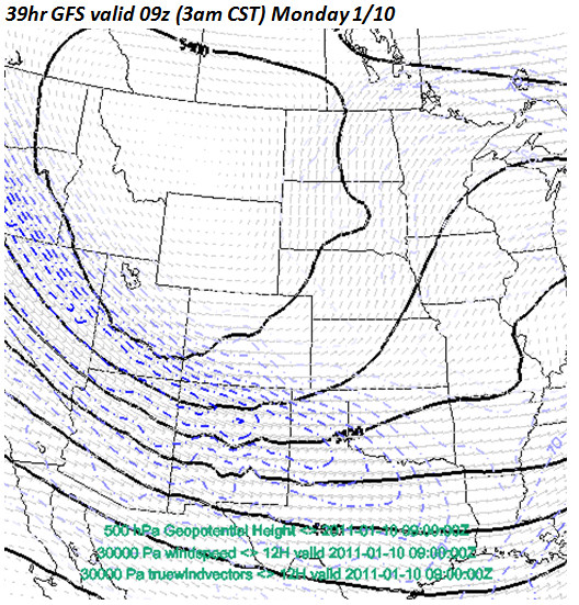
The “haves” and the “have nots” — The storm is coming out across the Rockies in pieces — not good for heavy snow in Dodge City. My updated thinking is 1-3″ in Dodge City for this event.  We’ve started to get some very light snow here at my house just north of town, but only a dusting of accumulation so far.  The expected cyclogenesis from the surface to about 700mb just isn’t going to take shape like earlier expected, and as such, only periods of light (maybe moderate at times) snow will occur through Monday.  Since the storm will  not be as developed for southwest Kansas, the winds behind the low will not be as strong, so the blowing and drifting component will also likely be less than I previously thought.  Unless radar echoes blossom in the area highlighted in Figure 2 (associated with the “x” near the Colorado-Utah border as shown in Figure 1) through the night, then this just isn’t going to happen for most of Southwest Kansas along and south of Highway 50.  The Hays and Wakeeney areas have already seen an inch or two of snow with the first little mesoscale wave while we were left high and dry in Dodge for the most part.  Yet another “blah” event it would appear.


Figure 1

Figure 2

Meanwhile, the real excitement isn’t even occurring across the Central Plains, but in the Southeast.  A major ice and snow storm is underway across much of the Gulf Coast/Southeast region (except for near the coast where it’s warm enough for all rain):


Figure 3


Figure 4

January 8, 2011

Southwest Kansas Winter Storm January 9-10 [post 1]

Filed under: 2011 Jan 10 — Mike U @ 9:15 pm

Accumulating snow, strong winds, and cold temps headed for Southwest Kansas. We are within 30 hours of the beginning of a winter storm to affect western Kansas. I have been working midnight shifts working this event at the Dodge City NWSFO, but the time has come to begin blogging a little bit about the storm. I think we’ll see 5 to 7″ of snow in Dodge City… that is my own personal prediction at this point based on the latest forecast track/strength of the approaching storm from various model inputs. Figure 1 shows the MSLP and surface wind pattern. Note the surface circulation from near Gage, OK to Childress, TX. This good for moderate/heavy snow for much of Southwest Kansas. This low level development is going to form in the left exit region of an upper level jet streak, which is shown in blue in Figure 2. The jet streak dynamics will be quite good. Winds will shift at the surface from southeast to northeast Monday morning…then to the north and increasing 20-30 mph by midday in Dodge City. Substantial blowing and drifting snow will occur across much of Southwest Kansas. The ECMWF model has pegged this for a number of runs now, and the NCEP models are finally trying to catch up with the ECMWF regarding the magnitude of wind and cold behind the front. Monday will be quite brutal around Dodge City.


Figure 1


Figure 2

Powered by WordPress