
Virtual storm chasing is coming to Underthemeso.com! With the addition of some new software…StormLab 4… (which I am currently Beta testing right now)… it will be easy for friends, family, and other storm chasers and severe weather enthusiasts to follow my storm chase pursuits during the severe weather season. On days that I will be out in the field, the underthemeso.com frontpage will go into "Chase Mode", which will contain a map with radar imagery, surface observations, and my latest GPS location. My cell phone provider has an incredible coverage over Eastern Colorado, about 95% of the entire state of Kansas, and a large part of Nebraska…as well as south into West Texas. These are the areas that I chase the most. I fully expect to be able to provide near-real time radar images with my GPS location during my chases probably 80% of the time, so you know exactly what storm I am chasing. I do have an external antenna for my data card, which will make it possible to hold a data signal longer…keeping a continuous download and upload process using StormLab 4.
and do not necessarily represent those of official National Weather Service forecast products,
therefore read and enjoy at your own risk and edification!"
March 14, 2007
November 3, 2006
Chase Acct: October 26 (Southwest KS) [part 2, "The Chase"]
 I departed Dodge City around 1:45pm or so, with the plan just to head south into the clearing area immediately south of the front so I could get a visual on things with respect to vertical Cu development. Low clouds were parting around the Clark-Ford Co. line with the temperature reaching the lower 60s. I made it as far south as the Hwy 160 junction just a few miles north of Big Basin… as the main band of convective looking clouds were pretty much right along this zone. I had a temperature of about 66°F at this location around 2:30pm. Scanning the skies from west to above my through east… it didn’t appear obvious yet where the best focus along this boundary was, and with this in mind, I decided to sit back for a little bit. I decided to call work (NWS-DDC) and let them know I was out, and provided them an observation since my current location happened to be one of the areas in our forecast area devoid of surface obs. At 2:30pm, I had an east-southeast wind about 10 mph with 67°F. If you look at a surface obs map at this time, you wouldn’t see any southeast winds…as there was only an extremely narrow corridor of east to southeast winds. Perhaps 10 miles south of me, winds were probably out of the southwest with very dry dewpoints in the deeply mixed dry intrusion air stream.
Fairly soft towering Cu dominated the sky in a NW to SE orientation along this front. I was beginning to get itchy feet and decided to move. There was a small base developing to my west… almost immediately overhead…as well as to my east-southeast, and all this stuff was slowly pivoting north. I figured I needed to favor east a little bit, so I drove back north on 283 to 4 S Minneola, where I drove east on an unpaved farm road approaching Clark State Lake. Driving north, then east to this new location, my temperature dropped to about 62°F with the wind out of the east-northeast…only 12 miles northeast from that previous location I was at. I found a good vantage point here now, near Clark St. Lake, with small towers trying to get going all along the boundary to my west through southeast. Through about 3:15pm or so, I still didn’t observe anything that prompted me to re-position myself… i.e. a significant, dark base with pronounced towering Cu growth… that is, until about maybe 3:20 or 3:25pm or so (estimation). Off to my distant west-northwest, I could tell it was getting increasingly dark, and I saw the first hint of the best, sharpest Cu devleopment atop this darker mass to the northwest some 40 miles away. It was at this point (with visions of 10 April 2005 running through my mind in terms of how things might "unzip" down the boundary beginning in the northwest first…then southeast later), that I decided to race back east to Hwy 283 to investigate this area, that appeared to be some 20 miles or so northwest of Minneola. I passed through Minneola (for the 2nd time of the day) going back north. Once I got out of Minneola heading north, I could certainly pick out what appeared to be a very impressive, long and dark updraft base looking WSW through NW. There even appeared to be a lowering of the cloud base on the northern portion of this base. I turned west on Wrangler Road, which is 3 miles north of the Ford-Clark County line (5 N Minneola). The time was now around 3:40pm, and the weather radio alarmed for the first tornado warning. The TOR was for that precise area where I was seeing this lowering to my distant west-northwest. The chase is on now!!
The very elongated base was very promising…suggesting very significant updrafting over a pretty large corridor extending south of where the TOR was issued. Continuing west, I kept my eye on the main area of interest to my northwest I had not even considered, however out of the corner of my eye, I see this thin "sheath" looking thing to my southwest. Possibly a landspout tornado! After watching this for about 15 seconds, I noticed a debris cloud beneath this feature confirming a weak tornadic circulation beneath this feature. Time was about 3:50pm and I immediately called NWS DDC with a report. I made it clear that this was farther south of where they were indicating possible tornado on radar and that it was farther south along the flank. I turned south 1 mile on 101 Rd. then west again on X Rd in the far southwestern tip of Ford County…crossing into extreme southeastern Gray Co. I stopped around 4:00pm at a location 1 mile west of county line with Ford and 2.5 miles north of county line with Meade. I was directly underneath the flanking updraft. I observed another dusty, weakly tornadic circulation to my southeast down the flanking line, but my main interest was still just immediately north of me. The problem was, the main storm was now getting too close to the cool air, as my temperature was about 57°F, yet there was fairly modest cloud base rotation at various points from my immedate NNW to my immediate southeast. I was probably not in the best location, as tornadogenesis could occur almost on top of me!

I had to keep up with the storm, so I headed back east two miles, then north on 101 Rd. (back into Ford County now)… not even two miles north, the sky was eerily dark with impressive rotation just a mile up the road. Cloud bases were also extremely low, making it tough to really see much structure. After stopping a couple times to monitor this, I crawled north to stay with this rotation. I continued about two miles more north before making the turn east as I was getting into more rain. I drove one mile east in the rain, and decided I was too far north now. I headed back south on 102 (Crooked Ck.) Rd. It was at this point that I needed to stay south along the flanking towers, and stay away from this cold air. The 3rd tornadic circulation I spotted now at 4:23pm to my southeast also confirmed this thinking  It was now "get south as quick as you can" mode. Thankfully, the unpaved roads I was on were well-grated, so the rain didn’t make them extremely slippery. I stopped briefly to photograph the distant, dusty tornado to my southeast then continued to drive south. I called to report this tornado at around 4:25pm, and it dissipated while I was on the phone with the report. I was at the intersection of Wrangler & 102 Rd. at this point, where I headed back to the east.

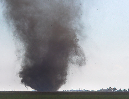
About 5 miles later looking south-southeast, a higher contrast (being a bit closer) dusty vortex developed at 4:30pm. I turned south on 108 Rd. About 1.5 miles later, the tornado to my south-southeast developed an impressive black looking dust cloud. Wow! At this same time, I noticed tumbleweeds swirling right in front of me and to my right in the adjacent field about 50-100 yards away… Wow again! Sensory-overload at this point with vorticity everywhere! The tornado to the south was now getting closer, since I was driving towards it, and I stopped briefly to photograph close-in shots of the circulation at the ground. I then turned east again on the County Line Rd. (Ford-Clark). At this point, I am now about 4.5 miles northwest of Minneola. After I turned east, I immediately stopped to photograph this beautiful, tall, dusty tornado churning away over baren farmland!! Classic! At various points, you could distinguish a faint condensation funnel above the intense ground level rotation/debris cloud. Time was now 4:35pm and I photographed from this location for about 5 minutes as the tornado travelled northeast. I used my 80-400mm lens exclusively at this location and got some interesting images of the base of this tornado with trucker traffic driving along Hwy 54 just on the other side of the tornado. The tornado was 2 miles away and Hwy 54 was 3. The circulation at ground level became indistinguishable around 4:40pm and I used that opportunity to keep driving east to stay with it. I reached Hwy 283 now with the tornado to my southwest approaching me! The tornado now redeveloped again with a classic, narrow condensation funnel about 1/3 of the way to the surface and a black, dusty debris cloud underneath… fantastic! (zoom-in of debris cloud) Time 4:42pm… I was obviously watching the movement of this thing with extreme caution, since it was essentially coming towards me. Needless to say, the car was running and I as shooting from right next to my passenger door! I began to notice some right to left forward motion, so the tornado was going to miss me to the south. The black debris cloud dissipated, but what was left was a sky full of tumbleweeds… a countless number of them! I was close enough to the ground circulation, that with my 400mm lens, I could discern the very tight rotation in the tumbleweeds about 1/2 mile to my south-southwest. The circulation was approaching Hwy 283 now to my south. I set myself up to photograph the tornado crossing the road, anticipating the shot. Fortunately (for the sakes of the shot), the tumbleweed debris remained intact as the circulation crossed the road. A sherrif was on the opposite side of the tornado watching this event unfold. The weak tornado crossed the road causing no damage to the powerlines, however a large quantity of tumbleweeds accumulated on the powerlines itself, marking where the tornado crossed. Time was now 4:48.


This tornado then ultimately dissipated in a farm field to my southeast, narrowly missing some farm structures. Not to be outdone, a larger scale storm circulation was now crossing Hwy 283 to my *north*!! A fairly large, "cigar" shaped funnel was now getting ready to cross the road, now keep in mind I’m in the same spot as where I was watching the southern tornado cross Hwy 283. This weak tornado crossed the highway to my north at about 4:52pm. It would be until several days later that I noticed a 2nd formidable funnel on the right hand side of one of my images, on the other side of Hwy 283. This would match the LSR report of "2 tornadoes at the same time, one on either side of Highway 283", at about this exact time ~4:53pm. I get ready to leave this location, but before so, another dusty tornado was evident to my southeast probably 5 miles away under one of the new developing towers. I drove into Minneola (for the 3rd time), then head northeast on Hwy 54 a few minutes before 5:00pm. When I got out of town and had a view again to the north, much to my surprise (or maybe not!), was yet another full-fledged tornado probably 3-4 miles away. This tornado appeared visually to be the strongest one I saw this day… it had a narrow, but fully condensed condensation funnel in contact with the ground and certainly appeared to be associated with some larger scale tornado cyclone that evolved from some supercellular processes. 3 miles northeast of Minneola, I headed north to get closer to this area of interest. This tornado was no longer visible as I was driving north as it appeared to become wrapped in rain/hail. I drove north about 3.5 miles and noticed a significantly occluded "tornado cyclone" feature with a bit of a tip near the bottom of this feature… although it wasn’t in contact with the ground, there was likely some weakly tornadic circulation beneath it. Time was now 5:05pm, and this feature was probably the remaining circulation from the full-condensation tornado I saw about 7 minutes prior. This would be the last tornado I would see for the day.


I drove south back to Hwy 54 and decided to keep chasing, heading northeast towards Bucklin. I entered light rain and low clouds with about 53°F… yuck! I then drove south on Hwy 34 to get back into the warm air. Along the drive south on Hwy 34, I had a great view of the low-topped Cb structure of the storms to my northeast. This storm produced a tornado north of Protection, however I never did see it, as it was too far away and I had hills blocking my view below the cloud base. After photographing the Cbs, I headed to Hwy 160 then drove west through Ashland and began my trek backhome…which took me through Minneola for the 4th and final time of the day

This was a fairly remarkable chase and was extra-special for being so close to home — one of the reasons I love it so much out here in Southwest Kansas! This chase marks my 4th October tornado day, dating back to my first October tornado in 1998 in Yocemento, KS.
Click for detailed map of events

http://www.underthemeso.com/gallery2/stormchase/chase06/2006oct26/
Mike Umscheid
November 2, 2006
Chase Acct: October 26 (Southwest KS) [part 1, "The Forecast"]
Given the uniqueness of this tornado event, I am breaking this chase account into two parts, the forecast and then the chase itself, for the purpose of documenting all the decision making processes that went on leading to the success of this chase. I will begin by stating that, yes, my geographical starting location (Dodge City) played a huge role in my decision to chase…being only 30 miles from the target area. I was working a 9pm to 5am shift earlier that morning, preparing the Southwest Kansas forecast for the time period Oct 26-27th… so I had a very clear idea of the overall synoptic scale situation impacting my forecast area. For brevity, I will not go into detail on the overall meteorology involved, but I would encourage you to read the Area Forecast Discussion (AFD) I wrote earlier that morning pertaining to the meteorology for October 26th SW Kansas forecast. You will see me mention things like mid level potential vorticity (PV) and maximized potential instability in the 800-600mb layer at the nose of the mid level dry intrusion. These are meteorological parameters unfamiliar to many storm chasers and amateur or new severe storms forecasters (mainly because they aren’t available on the internet) — yet are very key factors in many "cold-core" tornado events, I am beginning to find. While I didn’t mention the possibility of tornadoes in my AFD, I mentioned the key things that seem to be very important for "cold-core" tornado events. The reason I did not mention tornadoes in my AFD was the simple fact that the surface front appeard to be just too far south of my forecast area, and that any convection in my forecast area would be largely elevated above the shallow stable layer (but just barely). This was based primarily on the high-resolution NAM model. Intuition told me, however, that if the front arced back north at the nose of the dry intrusion/PV anomaly into SW Kansas, then insolation could really make things interesting with an enhanced tornado risk.
At any rate, I got home at 5am and went to bed with absolutely no intention to storm chase, primarily because I had to work again later that evening at 9:00pm, which would restrict me to a very tight leash within an hour or two of Dodge City. I woke up around 12:30 or so, and the first thing I did when I woke up was check out the weather, since I am always interested in seeing how my forecast is verifying in complicated weather situations like this one. Much to my surprise, I was seeing the visible satellite image revealing sunshine over the southern counties from Hugoton east to Meade to near Ashland. We were still in low stratus and drizzle in Dodge City with a northeast wind and 53°F. See the visible satellite image below, at 1745z (12:45pm CDT):

1km visible satellite image at 1745 UTC on 26 October 2006. The yellow oval indicates my chase target area after looking at this image and the 17z short-fuse composite.
I then looked at the 17z short-fuse composite and noticed a large surface moisture convergence bullseye over far southwest Kansas near the edge of the clearing on the visible satellite (see image below). Also of important note was that the surface theta-e ridge was nosing westward immediately north of the OK state border south of Dodge City. So, putting everything together from just these two charts told me everything I needed to know… the front was farther north and we could certainly be looking at more than just "small hail" that I had put in the forecast for this area earlier that morning at work! To me, it was looking much more like a potentially tornadic situation after looking at just these two bits of information. With nothing planned that day until I was due in to work again at 9pm that evening, I decided to give this a shot and head due south from Dodge City to investigate this convective environment. I was seeing some similarities to 10 April 2005... as storms were developing near the Colorado border… and as the day progressed, storms kept "unzipping" southeast at the nose of the mid level dry intrusion. When this "unzipping" hits the higher low level theta-e, then tornadic storms could be possible given the massive amounts of nearly stationary surface frontogenesis and vertical vorticity…not to mention enhanced horizontal streamwise vorticity (from 0-1km vertical wind shear) for tilting. I kept re-creating in my mind how this might unfold a-la 10 April 2005. I had my camera gear pretty much all packed and ready to go, as I usually do for impromptu situations just like this one. Since I do not shoot video anymore while storm chasing, the only gear I had to assemble was my photography pack and my laptop computer for GPS navigation. I didn’t even have my Alltel mobile internet setup going, since I can’t use it (my new Dell laptop does not have a PC card slot, but an ExpressCard slot, so I have to buy a USB adapter)… something I was going to address in the off-season. I left Dodge City for the drive south around 1:45pm or so. Chase account to be continued on next blog post…

The short-fuse composite (chart #1) that we are generating every hour at NWS-DDC. The valid time of this chart is 17z on 26 October, which coincides pretty closely with the visible satellite image above. Note the theta-e ridge nosing westward towards the maximum area of surface convergence.
October 26, 2006
Southwest Kansas Oc-tube-rfest!!
Jackpot on a gentleman’s chase… more details in a full chase account soon!

July 15, 2006
Chase Acct: July 11 (Southwest KS)
 Well this was about as impromptu of a chase as I’ve ever made… a day where I worked this particular event issuing severe weather warnings/statements during the early evening hours… followed by a short chase. I worked the day shift on the 11th, but I stayed over two hours until 6pm to help out with a severe thunderstorm watch in effect over our forecast area along with a few ongoing storms. At 6 o’clock, it was determined that the activity was isolated enough that my services were no longer necessary for overtime, so I went home. When I left to go home, there were a cluster of storms persisting over the Garden City area… and I could see these to the distant west. I didn’t think much of the storms as they were sub-severe at the time, and it did not cross my mind to go chase this storm given the lack of strong shear to support well-organized structures worthy of photographing. It certainly wasn’t a supercell…. at the time.When I got home I took a nap for about 45 minutes… waiting for the MLB All-Star game to start. I got up a few minutes after 7 and noticed Finney County to the west was under a severe thunderstorm warning. I pulled up a radar image and was surprised to see this storm had organized into a much healthier looking storm with supercell characteristics… an inflow notch and all! It was a quarter after 7pm and I was thinking about chasing. I think this would be the latest I had ever departed home for a daylight storm intercept! Sunset wasn’t until about 9:05pm, so I had plenty of daylight left to get to the storm and get some photography in…barring the storm held together.
I filled up the Jeep with gas in town and headed south out of Dodge. When I left, the storm was exiting the Garden City area moving south-southeast. I already had a great view of the updraft base of the storm from within the city limits. I had to get closer, of course, so I headed southwest on Hwy 56 a few miles to Road 107. I went south on the this dirt road until I got to Saddle Road where I continued west a few more miles. The storm revealed pretty good structure for the environment it was in with little in the way of wind shear. There was a band of 40-45 knots of flow in the upper troposphere around 250-200mb, and this seems to be critical for storm organization in the summer…whereas winds at all other levels were 15 knots or less. I would consider this storm a marginal supercell, as it did have some rotation to it, as evidence by the structure and organization, but it wasn’t really a full-fledged supercell producing golfball size hail or larger. Regardless, it was a beautiful little storm in a pristine atmosphere all by itself… perfect for photography! The storm bit the dust at sunset, but the remnant storm structure persisted long enough to get great, deeply saturated colors (1 2). Very rewarding for the total round trip of around 40 miles!


Photo Gallery >> http://www.underthemeso.com/gallery2/stormchase/chase06/2006jul11/
Mike Umscheid
June 21, 2006
Chase Acct: June 20 (Northeast CO)
Updated on June 29 with full account including many photos:
 On Tuesday 6/20, I wanted to take advantage of a day-off work to chase. As mentioned in the previous blog post, I liked the area in northeastern Colorado where post-frontal moist upslope flow was best…along the Cheyenne Ridge.
I left Dodge City around mid-morning, arriving in Oakley around 11am where I stopped at the library to refine my target. Keep in mind, I was chasing more “old school” this day… with no laptop computer… so I had to rely on my morning forecast and one or two updates until I got to my target. This gave me the opportunity to actually sit down and do a surface map analysis at 16z (see below).
At 16z (11am CDT), the surface winds in my target area were out of the north around 10 knots. Traditionally, this is what you do not want to see the late morning hours in your target area. The “rules” are a lot different on the high plains adjacent the Rockies, though. All the models clearly showed these winds veering around to the northeast then almost due east by 00z (7pm)… the prime time for photogenic storms. The low level moisture was very good for this region in the north surface winds, as you can see on the surface map… for those chasers/weather weenies/meteorologists who know how to read these

I then stopped for lunch and another quick update at the NWS in Goodland. Everything appeared to be on track, so I continued my trek to the Akron-Sterling area. A couple of developing storms were visible to my distant northwest when I arrived in Yuma, with the most prominent storm about 80 miles to my north-northwest along the Cheyenne Ridge near Sidney. This was my initial target storm, so I set a course for the Sterling area…and then points north from there should the storm hold together. By the time I arrived in Sterling, the storm was not looking nearly as organized. Jay Antle was nowcasting for me and he advised of a storm well to the north near Scottsbluff/Alliance, NE. At the same time, other towering Cu were developing to my west. I headed northeast on I-76 about 20 miles to the Crook exit. I hung around at this interchange, monitoring the developing towering Cu field back to my west. Another call from Jay advised that the radar echoes aloft were really increasing in the New Raymer area…about 50 miles west of me. This activity was moving in my general direction… and by the time an anvil canopy was established… I backtracked southwest about 10 miles to the Proctor exit, where I re-fueled and began my chase.
At Proctor, I headed west a few miles on the county road grid…then south, south of the interstate towards the Fleming area. I had this view of the developing storm to my west at around 4:30pm MDT. The storm was still fairly disorganized with at least three areas of updraft development from west-southwest through northwest. About 4:50pm, 5 miles south of Fleming, the updraft base was looking more impressive (1 2 3), yet still pretty elongated. While this was going on, another storm was developing almost on top of me, just to my immediate southeast. I was beginning to get rained on and I had to move. I was discouraged by this new, weak storm near the inflow region of this storm. I drove east on a county road southeast of Fleming to stay ahead of the main storm to my northwest…but driving through light rain from the new weaker storm to my immediate east. While I was driving east, a tornado warning was issued for my storm behind me to the northwest for a reported tornado northeast of Sterling. Whether there was really a brief tornado or not, it had to have been spawned from the updraft base I was watching/photographing south of Fleming. There could have been a weak, brief “landspout” type tornado, but I’m a little suspect of the report.


In the meantime, the storm to my immediate east was getting better developed, but it was finally moving far enough east/northeast of me. The main storm back to my northwest was still holding its own, but things were about to change very rapidly. My location was about 6 miles southwest of Haxtun where I stopped briefly along a north-south paved county road. Matt Crowther, who was also providing me nowcast help, called me on the phone to give me a radar update. In a span of less than 5 minutes, my main storm to the northwest was rapidly evolving into a bonafide supercell storm. The updraft base became much more focused and taking on rotation, with a wall cloud to boot (1 2). The wall cloud attained some rotation, but at the same time, it was becoming undercut by outflow. Remember that weak storm to my immediate east? Well it had now merged with the main storm (vertical) and was taking on impressive structure. The storm was now evolving into an HP supercell with a ton of precip. This is a look to the north at the portion of the storm that was originally that weaker storm out ahead of the main storm.


All this precipitation the storm was generating was detrimental to the supercell itself. It generated a huge surge of cold outflow surging south. Here’s a look to the west at the southern edge of the storm updraft, and another broad view of the entire storm updraft region. The supercell had pretty decent structure at this point (around 5:25pm), looking west-northwest from a location about 10 miles southwest of Haxtun. This would be the last of the good structure, though, as cold outflow would out-race the updraft enough to cut-off any good inflow into the storm. It looked really menacing to the north for awhile, but all this outflow became the death of the great supercell structure. It did make for some picturesque outflow-dominant structure (1 2 3) for awhile! (~5:33pm).


So now I had a decision to make. This storm was “going to pot” now with so much outflow ruining the show. I headed south on Hwy 59 to try to stay ahead of the outflow, with still some remaining updraft structure. I thought that it was still pretty early in the game, not even 6pm MDT yet, and there was always the possibility of the outflow surge becoming less dominant with new development farther south. In the meantime, the main original storm was still going, but the structure wasn’t nearly what it was to the north. I headed south to Clarkville, then east on Road 55 until I got to the sand hills where I had to head south a mile then east one more until I got to Road 51 which meandered through the sand hills. In this area of northeastern Colorado closer to Nebraska, you start entering more sand hill terrain. For future reference, Road 51 in northern Yuma County…between Wauneta and and Clarkville…is a wonderful little drive through the beautiful sand hills. The storm to the north-northwest was holding its own (6:30pm) despite being in that horrendous cool outflow generated airmass.


I was watching this storm overlooking the sand hills for a good half hour while meandering eastward towards Wauneta. The NWS-GLD office actually issued a tornado warning for this storm, which I found really interesting. At no point did this storm appear capable of producing a tornado with the messed up outflow environment it was in. As the sun was getting lower in the sky, thecolors were becoming more saturated and picturesque ( 1 2). The storm was looking more like a marginal supercell again to my north. I reached Hwy 385 at Wauneta and continued east a couple more miles with the storm to my northwest. It appeared as if the storm was on the downward swing and my attention was now becoming more focused to the new storm to my southwest near Yuma. I backtracked to Hwy 385 then continued south towards Wray to intercept the Yuma supercell. I stopped briefly to take one last look and photograph the Wauneta storm. Now it’s onward to the Yuma storm! (time ~7:35pm).
This storm must have formed at the edge of the surging outflow… and the ouflow must have come to a halt, because this storm was very well organized. It was a race against time, though, to get quality photography of this storm before the sun set. As I headed west from Wray on Hwy 34, there was a problem. The lighting was horrible with a lot of downstream precip being blown due east of the updraft area. Looking on the horizon, there were clear skies to the southwest and due south of this storm, so this was where I had to be… due south of the updraft, not east. With this in mind, I had to hop off Hwy 34 and drive south on unpaved county roads.


I had to find the photographer’s light… it had to be there! …and oh did I find the light. About 10 or 12 miles southwest of Wray…about 7 miles south of Hwy 34. I got south of the supercell updraft just in time for sunset. I quickly got the tripod out and had a field day. The colors were simply incredible. The warm hues of violet, orange, gold, blue… were stunning to say the least… and the supercell structure was very nice as well.
1 | 2 | 3 | 4


The view from west through north through east was just full of virbrant hues…illuminating the cloud structure of the supercell magnificently (vertical).


Immediately after sunset, the sky just lit up on fire. Vibrant pinks and violets dominated the sky…and cast an incredible hue on the landscape:
1 | 2 | 3 | 4


Once this great light faded… so did the storm chase. It was exactly what I was after…incredible light on a supercell thunderstorm. I drove south to Burlington to refuel and grab a bite to eat. After taking about an hour nap west of Goodland at about 12:30am CDT, a storm was developing nidely to the east. I stopped for about 20 minutes to photograph lightning near Edson along I-70. On approach to Dodge City around 4am, another storm was producing photogenic lightning just before arriving home, which was a nice little touch to the end of this chase. 1 | 2


http://www.underthemeso.com/gallery2/stormchase/chase06/2006jun20/
Mike Umscheid
June 19, 2006
Chase Day Fcst: June 20 (Northeast CO)
Tuesday the 20th is a work off-day for me, thus I plan to make it a chase day since there is a reasonable opportunity at a supercell within a half day’s one-way drive. All along, it looked like Iowa was the place to be for Tuesday the 20th… and it still does… however, Northwest Iowa is not a reasonable target for me from Dodge City. I’ve already done the Dodge City to Sioux City drive once this season… I think one time is enough, LOL. Since there is a reasonble opportunity for supercells closer (still 4+ hours away), I will opt for a closer play. Pretty strong zonal flow aloft with a short-wave trough embedded in the westerly flow will allow for organized storms in two areas it appears: Northwest to North-Central Iowa… and Northeastern Colorado. The better wind profiles and CAPE/moisture will be in northwest Iowa, which is where the best opportunity for tornadoes will be. The cold front will move south into western KS during the day tomorrow… however, the front will stall out given the strong zonal flow aloft. North surface winds in northeastern Colorado early in the day will turn to northeast then east by late afternoon/early evening… increasing shear and allowing post-frontal low level moisture to advect west. Storms should develop in terrain favored areas like the Palmer Divide and the Cheyenne Ridge. I am shooting for a target around Akron, CO at this point.
Below is the 24hr forecast from the NAM model valid 6pm MDT tomorrow (850mb Theta-E and wind). Note the warmer colors in the image (indicative of greater instability) in northeastern Colorado with easterly component winds advecting higher theta-E into northeastern Colorado.

For those who know how to read Skew-T (thermodynamic) diagrams, here is one for a location near Holyoke, Colorado (a 24hr forecast valid 6pm tomorrow) . Holyoke is in extreme northeastern Colorado about 30 miles south of where I-76 and I-80 merge.
90/55°F surface parcel yeilds about 1600 J/kg of CAPE. 0-6km shear is forecast to be about 40-45 knots by 00z, which is sufficient for supercell structures. Both the NAM and the NAM-WRF generate decent storms by 00z in this area with storms continuing well into the evening with high QPF values at 06z.

June 7, 2006
Chase Day Fcst: June 7 (Black Hills Region)
I am in Ogallala, Nebraska with Jim Leonard, Mike Theiss, and the Cyclone Tours. I’ll be chasing with them for the couple remaining days of my vacation. Looks like an interesting day in Southwestern South Dakota atop the upper ridge. Decent deep layer baroclinicity with adequate (yet still meager) moisture for supercells. Even though the 500mb winds will be fairly weak ~20 to 30 knots, a look at the forecast hodograph for the area reveals good length thanks to strong low level flow. The NAM shows a nice looking curved hodograph with a deviant storm motion of southeast at less than 10 knots. Storms should develop in the Rapid City vicinity and this is where we’ll be heading. Thursday (June 8th) looks like the same general area.
June 4, 2006
Chase Trip 2006: Day 12- Northwest KS (bust! & The End)
Saturday, June 3rd concluded Chase Trip 2006. We left Fort Morgan, Colorado around 1pm after a wonderful mexican lunch. When I got to my Jeep, I discovered that I could no longer power up my laptop computer. Both the external battery pack and the a/c adapter would not work… thus the problem lies with the computer itself. My laptop is now out of commision until I can get someone here in Dodge to look at it. Unfortunately, I have not yet transferred my photographs from the laptop to DVD, so I’m in a state of anxiety right now, needless to say, with respect to my storm and other chase trip photos. My laptop is about on its last leg anyway, it’s been so abused over the past couple years from so much storm chasing.
Anyway, we intercepted the remnants of a supposed tornado-producing storm near Sharon Springs, Kansas yesterday. When we got to Sharon Springs, the storm weakened and this whole area to our south was looking very outflow dominant and messy. We blew it off. Noticing new fresh towers going up near Goodland, we decided to meander towards Wallace and watch this. A small, very high based Cb moved southeast towards us and ultimately bit the dust like everything else this day. Saturday June 3rd was a bad day — short and simple.
This was Jon and Rob’s last day since Rob has a Monday flight back home. Jay and I said bye to Jon and Rob for the conclusion of Chase Trip 2006 and we headed back to Dodge City. This morning, Jay began his trek back to Lawrence.
It is now back to more impromptu, shorter-stint chases within a few hundred miles radius of Dodge City. Today, Sunday June 4, there may be more high-based pseudo-organized storms forming in the same place as yesterday. After I get my new cell phone in a couple hours and a Kansas Delorme Atlas & Gazateer, I may head northwest to photograph these storms, should the develop. It’s back to old-school chasing for awhile until my laptop is revived again or I get a new one!
Tomorrow, Monday June 5, there is a better opportunity for organized severe storms and even a decent supercell or two near the KS-NE border. I’ll be chasing this for sure, since I”m still on vacation until June 8th. Paper maps, library stops for data, NOAA weather radio on the scanner… Wow! It will certainly be different chasing this old way after all the luxuries of incredible cell-data on the road with my Alltel+Kyocera card setup. It’ll be fun though, more eyes on the skies where they should be!
June 3, 2006
Chase Trip 2006: Day 11- Rocky Mountain Nat’l Park (sightseeing, no chase)
Well yesterday, June 2 was another down day with respect to storm chasing. After discussion within our group, we decided to hang tough with this marginal pattern vs. blowing off the rest of the chase. We are taking things one day at a time. Anyway, yesterday it looked like Saturday June 3 might be a decent enough opportunity for high based supercells in northwest flow aloft over southwest Nebraska. With this in mind, we optioned to drive around and do more sightseeing in the Rockies.
After Rob and Jon dropped off Mitch at Denver Int’l, they met back up with Jay and me in Estes Park. We spent the afternoon driving through the park with nice scenics and wildlife. The snowfields are pretty nice right now above 10,500 ft. or so. After driving through the park we headed back to Estes Park then to our final destination of Fort Morgan, where we are this morning. Driving to Fort Morgan last night, we noticed on the internet a couple of really interesting supercells in Northwestern Nebraska in the Sandhills. These supercells were in a fairly weak flow environment with meager moisture. This gave us some hope for today’s chase in western Nebraska/Northwest KS.


Jon, Rob, and Jay from left to right.
