High Plains Drifter


disclaimer:  "The meteorological views/forecast thinking expressed are those solely of the author of this blog
and do not necessarily represent those of official National Weather Service forecast products,
therefore read and enjoy at your own risk and edification!"

April 26, 2009

Chase Acct: April 24, 2009 (KS-NE Border)

Filed under: Chase Accounts,Latest Chases,Storm Chasing — Mike U @ 11:01 pm

I photographed a couple severe thunderstorms, one of which becoming a marginal supercell with striated updraft structure, near the Kansas-Nebraska border from near Belleville, KS points east towards Washington, KS. A more detailed account will be written on this blog post, but for now, here are a few images from the chase:

(edited 5/20/09 at 12:20am CDT):

Full chase account:

April 24, 2009:  Cold Front Severe Storms Along Kansas-Nebraska Border (Chester, NE to Mahaska, KS to Hollenberg, KS)

I targeted the Kansas-Nebraska border on 24 April 2009 where I thought the western extent of severe storm development would occur along an advancing cold front.  Typically, cold front storms are not exactly photogenic, but I thought I would try my luck.  “Tail-end Charlie” storms, regardless of whether they are along a cold front or not, can sometimes be fairly productive from a photography standpoint with at least decent storm structure.  I wanted to target the nose of the warmest air, also at the nose of the mid-60s dewpoints that were expected to move up into the area from south-central KS.  A look at the forecast hodograph showed a clockwise curved wind profile on the hodograph, which was promosing for perhaps supercell structures.  I left Dodge City late in the morning for a target between Belleville, KS and Hebron, NE by 4:00pm or so.

I arrived in Hebron, NE to a clear sky devoid of any cumulus growth at 3:00pm {2001}.  Where was the western extent of development going to be?  The latest RUC and NAM models seemed to suggest that the western edge would be just a bit east of Hebron, so once cumulus did finally grow along the front to my northeast, I began to head in that direction at about 4:20pm {2126}.  I guess part of this decision was based on the fact that after sitting in one place for over an hour, you start to second-guess your target.  I drove east to Fairbury, reaching that location at 5:00pm or so.  By this time, small storms were beginning to develop — first to the northeast of my location, then north.  Once I reached the small community of Harbine, I took a few photos of the initial cumulus congestus growth to my north {2223}.  Looking back to the west-southwest, all of a sudden there was fairly substantial towering cumulus growth in that direction…as far west-southwest as the Hwy 81 corridor to the south of Hebron where I was sitting between 3:00 and almost 4:30pm {2236}.  I quickly realized that I should have just stayed there, but there was no time to dwell on that — it was time to get back southwest.  I decided to take Hwy 8 through Reynolds and Hubbell, NE to get back to my original target.  There was fairly aggressive development into a severe thunderstorm between 5:40 and 6:00pm very near the Kansas-Nebraska border southwest of Chester, NE {2300}.  The storm was moving to the northeast, which made for a perfect intercept given my location to the northeast of the storm.  The problem was, the storm was moving in an unfavorable direction with respect to the cold front.  While the storm was moving northeast, the cold front continued to move south, and rapid undercutting was inevitable.

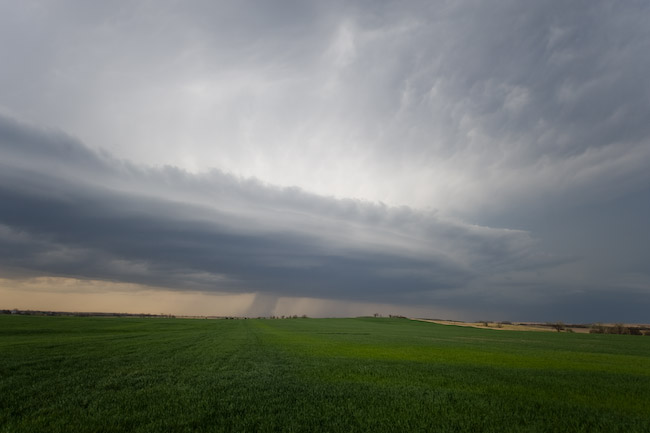
I managed to make it to Hwy 81 at Chester, NE about 10-15 minutes prior to the core making it to the highway, and off to the south I went.  I crossed the frontal zone about 5-7 miles to the south of the strongest radar echoes, so this storm was very undercut by the cold front by this time.  At the interface, I noticed a few gustnadoes swirling in the farm field to my immediate southwest, but they were extremely short-lived and very weak at that.  I called the Topeka NWS office to let them know of this observation.  I stopped a few times south of Belleville to get some structure photos between 6:35 and 7:00pm.  By 7:00pm, the development to my west was becoming a bit more interesting to my northwest {2356}, although north of the front.  I finally headed east on a farm road between Belleville and Agenda, following the eastern storm (there were two storms of interest by this time:  one northwest of Belleville and one near Narka {0009}).  I liked the overall structure of the Narka storm so I continued to blast east to stay in a somewhat reasonable position.  I got back on paved Hwy 148 and continued east toward Agenda.  I stopped just east of Agenda to shoot structure to the north, some 20 miles away {0028}.  I had to be at this distance to get the structure shots I wanted since the storm was undercut by the cold front.  Even though the storm was undercut by the cold front, it still revealed some marginal supercell structure with a somewhat tiered elongated updraft structure.  The storm looked less supercellular with time as the structure was becoming more linear in appearance as another cell was forming in the immediate wake of the first.  Nevertheless, there was still decent, somewhat photogenic storm structure at sunset as I was positioned southwest of Washington {0105}.  I photographed the structure of this elongated activity up until shortly before 8:20pm {0115} when darkness was beginning to set in and the best of the structure was fading.  All in all, not too bad of results considering what I was up against (fairly strong cold front causing severe undercutting problems).


April 20, 2009

Chase Acct: April 16, 2009 (Southwest KS)

Filed under: Chase Accounts,Latest Chases,Storm Chasing — Mike U @ 4:20 am

April 16, 2009 — Daytime lightning images near Sitka, KS

I set out from Dodge City to chase some elevated thunderstorms with the sole objective to capture some daytime lightning images.  I had just arrived home from a very long road trip to Las Vegas, NV for a bowling tournament at around 7:00am.  After about 3.5 hours of sleep, I woke up and noticed decent thunderstorms on radar to the southwest of Dodge City with rather prolific lightning production.  I was immediately intrigued and with the activity moving closer to Dodge City, I decided to make a go at some lightning photography.  I left Dodge around 12:30pm, and about 10 miles south of town, realized I had forgotten my tripod.  Obviously, for the kind of images I wanted, I absolutely needed the tripod, so I went back home to retrieve it.  On the way back home, I briefly visited with Robin Lorenson, Mike Phelps, and Aaron Blaser in town as they were on their way to Colorado for a late afternoon/evening storm chase.  Since I had to be at work at midnight, I could not chase that far from Dodge.   I decided to intercept storms moving north out of far northwest Oklahoma into Clark County, so I drove to Bucklin then south to Sitka.  I reached the storms of interest just south of Sitka where I set up at a location for about 20 minutes.  I did manage to capture a few cloud-to-ground flashes using the Lightning Trigger, although I overexposed one of them at f/11 since the flash was so close!


April 18, 2009

Chase Acct: April 17, 2009 (Southeast CO)

Filed under: Chase Accounts,Latest Chases,Storm Chasing — Mike U @ 6:14 am

This post will be brief — I will write a more detailed account soon, but for now here are a couple images of the partially rain-wrapped tornado I observed near the Colorado-Kansas border yesterday evening at around 8:00pm CDT (7:00pm MDT).  The time stamp on the first image is 8:03:45 and the second image is 8:04:33.  I was photographing this tornado using a telephoto lens anywhere from 80 to 150mm focal length at roughly 1/30 of a second on the tripod.  My observing location was 4.5 miles east of Coolidge about a mile or two north of Highway 50 on an unpaved road.  The view was looking due west in these images toward Holly, CO.  I would estimate this tornado being very close to Highway 50 somewhere not too far from Holly based on radar data at the time.  Even though the primary condensation funnel never fully made it the surface, there were occasional “whisps” of condensation very close to the ground beneath the funnel… as well as at times concentrated rain curtains beneath the funnel, which gave me confidence of at least low-end tornadic circulation at ground level.  More later.

March 24, 2009

Chase Acct: March 23, 2009 (south-central KS)

Filed under: Chase Accounts,Latest Chases,Storm Chasing — Mike U @ 5:25 pm

For me, this was just an “average” chase.  I intercepted two supercell thunderstorms on this day after leaving Dodge City shortly after Noon.  My target was Kingman, KS, but I never got there before storms started forming.  I was already in “chase mode” when I reached Pratt, as the first decent storm echo on radar was developing to my south-southeast.  It was really early in the day, so I just opted to let the storm come up to me on Highway 54 at Kingman.  From Kingman, I followed the storm… a rather smallish LP or “dry classic” type storm… north-northeast from Cheney Lake up to Highway 50 near Burrton.  This was indeed a “race chase” as this storm was trucking north-northeast at around 50 mph.  This left me very little time to photograph the storm other than brief stops for a quick snap.  A lot of my images of this storm were shot while driving up north on the paved road from Cheney dam to Haven.  A large wall cloud formed briefly, with a beautiful rear-flank downdraft clear slot eventually taking shape to my north-northwest near Haven.  These were probably my best images of the chase day.

Once the storm reached Highway 50 it became less organized and was just continuing to truck away from me so I said to hell with that storm.  I then drove east to Newton, and with a new focus down along the Oklahoma border, I made a goal to get down toward the Winfield area.  A fairly impressive supercell emerged out of a cluster of storms southwest of South Haven.  An extrapolated path took this storm to South Haven about 15 to 20 minutes before I was expected to reach the South Haven interchange.  When I first got a good glance of the structure of the storm, I realized that it was likely not going to produce any large, photogenic tornadoes, so I went into “structure mode” — basically getting far to the east of the storm to get decent supercell structure shots.  The structure of the storm was pretty good while I was on Hwy 166 looking back to the west and southwest…with a very long, broad inflow band taking shape from the north through northwest feeding into the main updraft area.  It just looked like there was too much rain-cooled air being re-ingested into the updraft area…however given such strong storm-relative inflow winds, rain-cooled outflow could not surge very far from the updraft area.  So what ended up happening, from my observations, was that you would end up with nice looking wall clouds for a few minutes — only to evolve into crappy looking fragmented pseudo miniature shelf-cloud looking features.

The best of these wall cloud features I photographed was along Highway 166 at about 4:56pm CDT looking west from a location ~ 2 to 3 miles west of Arkansas City.  Very briefly, before I had my camera in hand of course, there was what appeared to be a bulbous looking laminar appearance protruding from the wall cloud about halfway to the surface.  I tried to get a photo of this, but was just a little too late.  This would have been almost directly in line with Highway 166, or barely south — not too far from Ashton.  Anyway, after this, the wall cloud became fragmented with outflow seemingly winning out for that feature.  I continued into Ark City and then eventually north on County Road 1 about 7 or 8 miles east of Ark City.  The structure was never really the same as it was back farther west…and the whole thing was just becoming a big mess — and not very photogenic.  Nevertheless, I captured a few images as the storm’s core was approaching my location shortly before reaching Hwy 160 east of Winfield.  Not long after this, I gave up on this storm given the yucky structure and it moving farther east toward southeast KS.  I’ve never had luck photographing a storm in southeast Kansas, so I figured this storm’s structure would continue to degrade.  I drove back to Winfield and got some dinner at the Mexican restaurant in town.  After this, I headed south a bit to photograph backside Cumulonimbus development of storms coming up from far northern Oklahoma with only marginal success.  I called it a chase right at sunset and began my trek back to Dodge City.  All in all, not too bad of a chase.  I’ve had much better — and much worse chases — that’s for sure.


« Newer Posts

Powered by WordPress