High Plains Drifter


disclaimer:  "The meteorological views/forecast thinking expressed are those solely of the author of this blog
and do not necessarily represent those of official National Weather Service forecast products,
therefore read and enjoy at your own risk and edification!"

July 14, 2009

Chase Acct: July 12, 2009 (Eastern CO-Northwestern KS)

Filed under: Chase Accounts,Latest Chases,Storm Chasing — Mike U @ 8:06 pm

…Long-lived severe storm complex with beautiful striated updraft/shelf cloud structures — from the Palmer Divide to Oakley, Kansas…

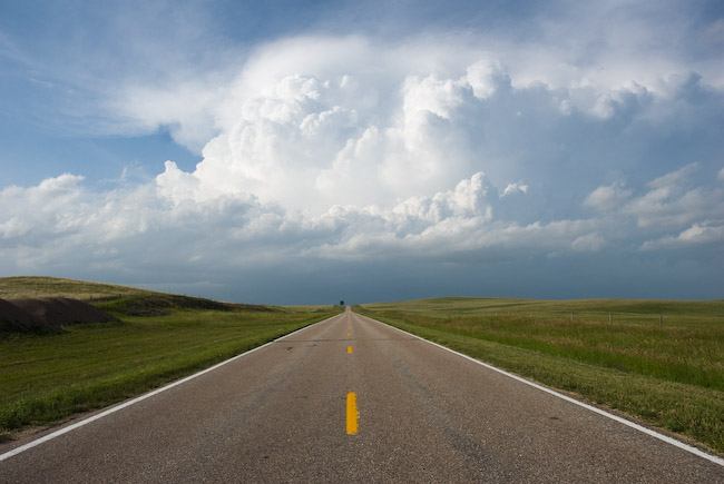
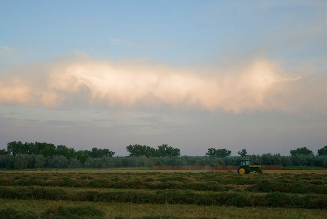
I must say, I was extremely pleased with how this chase turned out.  I had very little choice other than to chase as close to home (Dodge City) as possible, seeing as I had to start day shift early the next morning.  I began this chase in Sidney, NE with a target of the Palmer Divide (around and south of Limon, CO) in mind.  Water vapor satellite was showing a subtle jet streak/mid level moist band moving into western Colorado, timed to come out into the adjacent high plains by afternoon.  Moisture was still very good across eastern Colorado to the east of the Palmer Divide with dewpoints in the lower to mid 60s across far eastern Colorado, so once storms reached this moisture/high CAPE, they should thrive…given the marginal wind shear.  By the time I reached Limon, I already noticed decent towers developing over the Palmer Divide, so I drove southwest on Highway 24 — “the highway to Palmer storms”.  I drove as far southwest as Simla before I decided to hang out on a farm road.  It’s so green out there.  The landscape is just beautifu on the Palmer with wonderful wildflower growth and green rolling hills.  I would love to live out here!!  Anyway, as a young storm started to grow to my west, I ventured southwest to Calhan where I then began my journey on farm roads south toward Hwy 94.  The incipient storm was small and had some shape to it with a precipitation core separated from the updraft area.  Eventually, though, numerous other storms developed to the south and southeast of this initial storm and it quickly became a mess.  All this activity was still somewhat displaced from the good moisture, so I figured I had to give it some time to sort itself out.  Meantime, I was noticing aggressive Cb growth well to my northeast…to the northeast of Limon, and I gave it some thought to just totally abort the Palmer Divide mess and reposition to the northeast.  The easternmost storm of the Palmer mess was actually a pretty little storm with a stout, compact precipitation core coming straight down out of the center of the smallish Cb.  I took a couple photos of this.

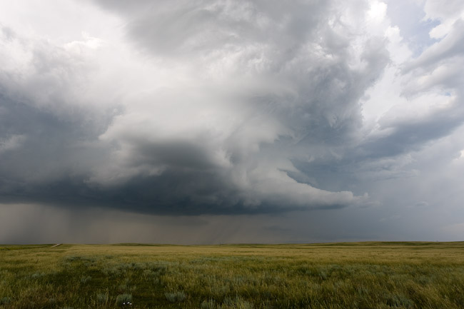
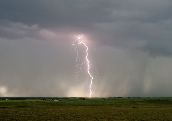
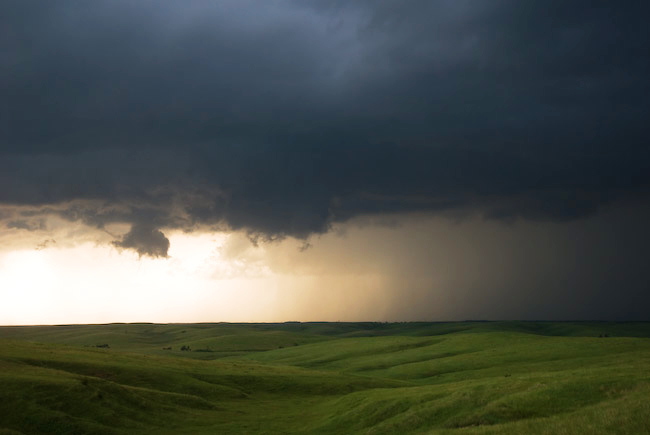
An elongated base was just to my south…just south of Hwy 94 from just south of Yoder to south of Punkin Center.  This was slowly moving north toward the highway, so my thought was just to get to Hwy 71 (Punkin Center).  Before I did that, though, I drifted south about a mile or so to try and photograph some of the intense lightning that was barraging the location behind me back to the west.  I tried to get out of the rain with some luck and captured a couple daytime CG’s with the lightning trigger.  All of a sudden, this storm rapidly gained strength right in front of me to the west and northwest.  I got back to Hwy 94 then blasted east to Hwy 71 where I went south.  This began the real chase!  My first stopping location was about 6 miles south of Punkin Center where I photographed a nice updraft structure with the telltale jagged, scalloping appearance that is typical of strong Colorado storms.  I wanted to get east to stay ahead of this, so I started taking more dirt farm roads east and north to Karval.  Along the way, this storm continued to organize nicely, eventually spewing out an ominous white scud cloud against the dark mass behind it.  Excellent contrast!!  I got one image of this massive white scud cloud against the dark storm behind it…complete with a cluster of cows in the desolate pasture.  One of my memorable scenes of this chase.  Another one shortly after that was a high-contrast slanted scud cloud nosing down at an angle above a distant farmstead — the high contrast scenes I’m after!

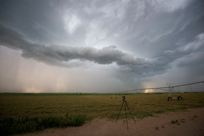
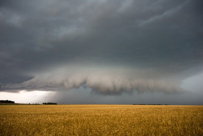
I continued to take this road east out of Karval, and at this time I’m without internet data, so I wasn’t providing any updates on my Chase Mode page.  The storm was at its strongest near Karval in southern Lincoln County, and the structure was rather impressive given the marginal mid-upper level flow situation.  The storm was really beginning to accelerate as it was becoming outflow dominant, so I couldn’t stop long to shoot the storm.  I continued to drive east and south on farm roads all the way to due south of Wild Horse (by about 12 miles or so).  The storm behind me by this point became so encompassed with dust it was not worth photographing anymore.  So now what to do?  I noticed the next possible development along this outflow surge to my northwest.  The updraft structure was looking a bit more impressive with striated banding, so this was the next one to chase.  I then followed farm roads east and north to Highway 287 to the south of Kit Carson.  Along the way, I photographed this new storm updraft at a couple different instances.  Soon, this storm began to create a big outflow surge complete with widespread blowing dust — it was now a chore just to stay ahead of the surging dust — and I did this all the way east until I got to Cheyenne Wells taking dirt farm roads the whole way.  I finally got back to paved roads at Hwy 385 with the gust front barrelling toward me.  I did not make it into Cheyenne Wells before the dust.  I shot a few images of the surging dust coming toward the highway before I became involved with the dust.  Visibility at the front of the dust was less than a half mile, and briefly just a couple tens of feet!  I estimated 55 to 60mph winds or so at my location there near the intersection of Hwy 40 and 385 just outside of Cheyenne Wells.  Now to get back east.

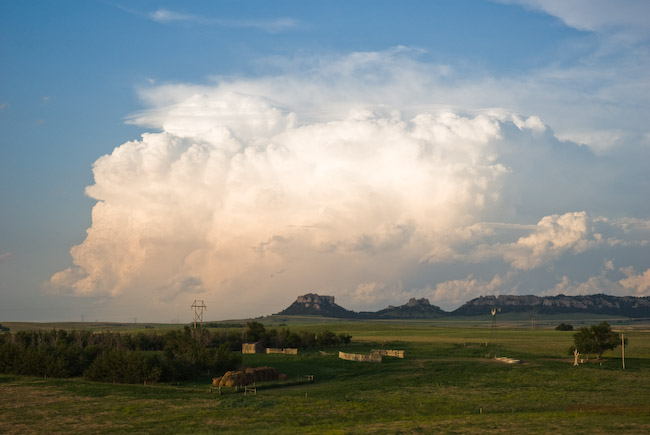
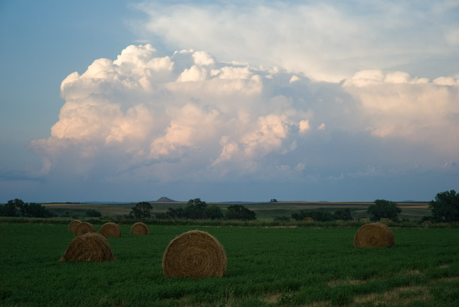
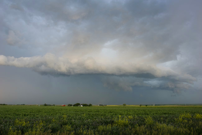
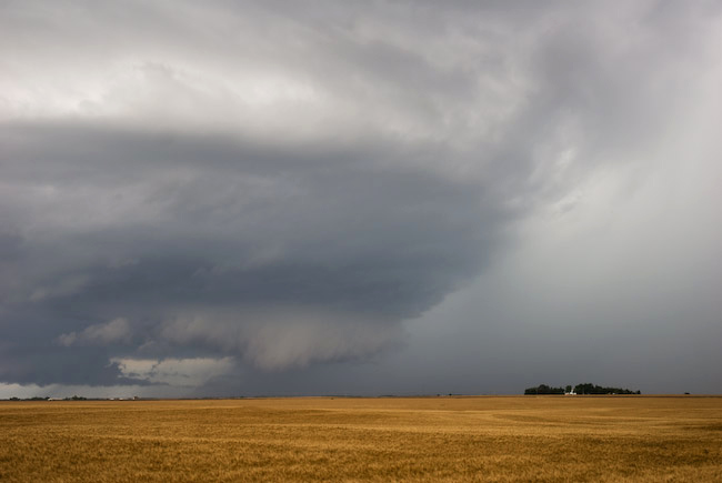
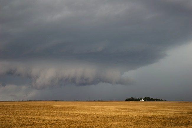
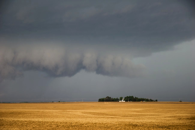
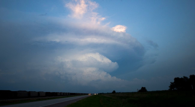
I had to blast east on Hwy 40 to get in front of the storm updraft/shelf cloud again where the good images were to be found.  It was a chore.  I followed an 18-wheeler into Kansas from Cheyenne Wells, which was swerving against the 50 mph gusts.  Needless to say, I kept my distance!  I didn’t get ahead of the gust front again until I got to Weskan, KS…and it wasn’t until Sharon Springs when I got a good glimpse at the beautiful high-based multi-tiered shelf cloud.  This was one of the more photogenic shelf clouds I’ve photographed I think.  The striations were very crisp, clean, and highly photogenic.  At times, there were individual eddies along the gust front that bulged out in spots which really improved the structure.  This was really cool!  I continued to photograph this shelf cloud, now that I was far enough ahead of it…from Wallace to Winona to Monument along Hwy 40.  I had to be careful, though, because my fuel needle was precariously close to “E”, but I knew I could make it to Oakley.  Man what a beautiful shelf cloud in the golden hour light!  At Oakley, it finally got dark enough and I was satisfied enough with this chase to just end it right there and begin my trek back to Dodge City.  All in all, for a storm that really wasn’t a supercell, this was another fine day of storm photography on the High Plains of Colorado!  Here are some images from this chase:

This SimpleViewer gallery requires Macromedia Flash. Please open this post in your browser or get Macromedia Flash here.
This is a WPSimpleViewerGallery

July 12, 2009

Chase Acct: July 11, 2009 (Southeast WY)

Filed under: Chase Accounts,Latest Chases,Storm Chasing — Mike U @ 9:45 am

After waiting patiently all afternoon along highway 26 in Goshen County, WY, I intercepted 3 severe storms that were briefly marginal supercellular in structure that first initiated off the mountains west of I-25 early in the evening.  The first storm was west of I-25 to the northwest of Chugwater, WY.  I managed to get a couple good cloud-to-ground images with the storm’s updraft using the lightning trigger.  I sat at a parking area along the interstate for a good half hour or so watching this storm approach.  This storm weakened and another more formidable severe storm/marginal supercell formed to the southeast of this one near Chugwater.  I took the desolate highway 313 east, which ended up being a perfect road for this storm intercept as it was basically following me down the road.  A classic, high-contrast rain-foot developed at the southern edge of the precipitation core near the updraft/downdraft interface.  The sounds and smells to go along with the sights of this storm.  This was the reason I took this trip!!  This storm also waned, but yet a third storm with some supercell structure formed southeast of this one… to the west and northwest of LaGrange (this is the area where Vortex-2 intercepted the long-lived tornado back on June 5th).  At sunset, the blues, oranges, and violets were vivid.  Fantastic color.   I continued to photograph this storm after dark as it rolled east into Nebraska to the northwest of Harrisburg.  Below is a sample of images from this chase:

This SimpleViewer gallery requires Macromedia Flash. Please open this post in your browser or get Macromedia Flash here.
This is a WPSimpleViewerGallery

July 11, 2009

Chase Acct: July 10, 2009 (NE Panhandle)

Filed under: Chase Accounts,Latest Chases,Storm Chasing — Mike U @ 10:29 am

My original target on July 10th was Cheyenne, WY in anticipation of late afternoon storm development off the Laramie Mountains.  As it turned out, I ended up chasing non-mountain generated thunderstorms, and eventually chased a storm rather far from my original target.  I sat in Cheyenne for much of the early/mid afternoon, however initial congested cumulus clouds were not doing much, and was actually starting to think I was too far south being in Cheyenne.  There were two areas that caught my attention:  1) heavily congested cumulus field to my northeast, way up near Harrison, Nebraska and 2) some towers forming west and northwest of Wheatland, WY (near Laramie Peak).  I blasted north on I-80 to Wheatland then took a scenic road east to Ft. Laramie along Hwy 26.  An impressive Cb formed to my northeast as I approached Ft. Laramie, and given the lack of convective embryos back to my west toward the mountains, I made the decision to go after a sure thing:  A rapidly developing storm to my northeast.  Given the road network, I wouldn’t be able to make an intercept of this storm until I got north of Mitchell-Scottsbluff.

I took Hwy 29 north about 25 miles with a good view of the Cb right up the road.  I stopped once for photos along this highway.  I then headed east to jump on Hwy 71.  The storm was to my northwest about 10-20 miles away, and it was moving southeast toward me.  I barely made it to a farm road grid west and southwest of Hemingford.  I thought I was in good shape — getting into a pretty good position with this storm, however once I got into a decent position, the storm rapidly declined in intensity.  The storm had split earlier on (supercell processes at work), and the left member of the split moved northeast away from me.  As it turned out, the left member dominated, and the right member (the one I was chasing) died.  This is opposite what usually happens, however the local wind shear profile in this area had either a straight-line hodograph or slightly counter-clockwise looped hodograph in the low-mid levels — which is a little more unusual as low-mid level hodograph shapes for typical supercells tend to have a clockwise curvature to it.  After my storm died (the right member), I drove north along Hwy 2 to photograph the backside of the severe left-mover supercell which went through Chadron.  It began to get dark as I neared Chadron and the storm was also beginning to die, so I ended the chase here.  Below are a few images from this chase:


July 10, 2009

Chase Acct: July 9, 2009 (South-Central NE)

Filed under: Chase Accounts,Latest Chases,Storm Chasing — Mike U @ 7:15 am

This was a bust.  No storms developed in the target area.  I actually had two target areas, and even the secondary target area failed to produce a supercell storm… so I’m really not all that disappointed.  My primary target was the slowly moving front across Central Nebraska.  A couple versions of the NAM and even RUC models hinted at possible convective initiation along the boundary in central Nebraska, and per model soundings, if surface temperatures reached 95 degrees up along this front, there would be a shot.  Well, the warmest temperatures I saw on obs as well as per my car’s thermometer, the temperature in the vicinity of maximum convergence along the front never got much above 91 or 92.  The mid level temperatures were simply too warm.  When the cumulus looked at flat as they did for so late in the afternoon, I knew I was in trouble, and it would take a miracle for something to grow into substantial, hard towers and even further into a storm.  The cumulus field did become a little agitated by 5:30 to 6:30pm where I was sitting at southeast of Minden, Nebraska, but it never got beyond that point.  At 7:30pm, I called it quits and headed west toward McCook to set up for Day-2.  Below is one photo I did take of some high level virga that crossed the area around sunset:

June 24, 2009

Day 13 (June 23): Southeast WY/Southwest NE Panhandle Storms

Filed under: Chase Accounts,Chase Trip 2009,Latest Chases,Storm Chasing — Mike U @ 9:18 am

From a tornado perspective, my target area failed. From a unique chase/photography experience, it was a success. I chased WEST of I-25… yes, you heard me right. A supercell formed north of Laramie and just sat there developing on the southwest flank. I said to hell with waiting on it, I’ll just drive to it. It was a very risky move because should other more siggy storms develop east of me, I would be screwed because the one-way trip around SR211/Horse Creek Rd. is about 65 miles. This road was perfect to get a closer view of the storm, but the problem was the 7000-7500 foot terrain between me and the updraft base and any lowerings… so about 80% of the drive was just seeing a dark mass to my west without seeing what was beneath the base. Finally, once I neared Horse Creek (NW of Cheyenne), I could see underneath the base. There was indeed an ominous scuddy lowering. I had to break out the 80-400mm lens since the storm was rather far away still. The southernmost of the conjoined, elongated convective entity became increasingly photogenic as I approached Federal, WY. Once again, I took advantage of the telezoom lens to get some compositions of the distant, but very beautiful supercell Cb with mountainous terrain on the horizon. It was a nice sight, complete with classic blocky lowering beneath the distant rotating storm.

Ultimately, this initial storm complex sent out a wad of outflow that ended up becoming the end of the potential tornadic phase of this chase. I followed Hwy 85 then 216 to Albin and became increasingly frustrated at the lack of any structure. Not even tiered shelf structure. I essentially threw in the towel and made my way to I-80. A storm cluster south of Kimball was sparking fairly consistently so I decided to shoot this. Another small supercell-looking cell then developed back west, so I turned back west on I-80 to Pine Bluffs again. As this thing was dying, yet another storm was developing just about on top of my during my drive back to Pine Bluffs. Once I reached Pine Bluffs, I decided to hang out on Hwy 30 northeast of town adjacent Union Pacific rail line. The golden hour light was getting pretty good with numerous convective elements to photograph. I even had a distant rainbow looking east down Hwy 30. That’s right, today I photographed BOTH a morning rainbow AND an evening rainbow. I find that extremely unusual and quite rewarding actually. The sunset light was just getting better and better. Rich, vivid pinks, violets, blues made the convective elements in the sky just jump out at you. Then, before I knew it, I had a pink storm structure to my north with a nice rain-free base and lowering! A large “scud bomb” developed beneath this lowering, and I had an amazing scene in front of me to my north. A non-severe pink storm with a gigantic “tornado look-alike” hanging down below the rain-free base. Simply amazing sky. Just phenomenal. I was fretting about the mis-target today (not chasing the higher CAPE along the front farther east into Nebraska), but that was only until the incredible photographer’s golden hour light gave me a nice treat. I’ll say that this was nice cap to my chase vacation — one with many wild swings in emotion, as most of you have all read about through the various blog posts.

Day 12 (June 22): North Dakota Supercells

Filed under: Chase Accounts,Chase Trip 2009,Latest Chases,Storm Chasing — Mike U @ 9:11 am

I photographed several severe storms/supercells from northeast of Dickinson to Mandan to Wishek, North Dakota.  Below are a few images from this chase:

June 22, 2009

Day 11 (June 21): Far Northeast Colorado Storms

Filed under: Chase Accounts,Chase Trip 2009,Latest Chases,Storm Chasing — Mike U @ 5:05 am

Lightning and Non-Severe Storm Structure from Iliff to Sedgwick, Colorado

Here are a couple images from June 21st chase.  The color contrast was beautiful, and I managed to get a few decent daytime CG’s with the lightning trigger.  No time for a report since I have to hit the road for today (June 22nd) chase.

June 21, 2009

Day 10 (June 20): Pratt to Hutchinson, KS marginal supercell

Filed under: Chase Accounts,Chase Trip 2009,Latest Chases,Storm Chasing — Mike U @ 9:07 am

I left Dodge City mid-afternoon and headed to Greensburg as a staging point for severe thunderstorm development.  A corridor of 2000-3000 J/kg CAPE developed in the wake of earlier day showers and thunderstorms with a decent east to west surface boundary.  An interesting storm emerged out of a cluster of disorganized activity to the southwest of Pratt.  The storm had some decent structure initially, with a formidable lowered region from the updraft base.  All the unpaved farm roads were still fairly wet from the earlier day rainfall, so I had to stay on paved routes.  This meant core punching the storm north of Pratt.  I finally got ahead of it again to the west of Hutchinson.  A new cell developed out ahead of the former storm by about 10 miles or so…which eventually merged with the former storm to the northwest of Hutch.  Rotation in the storm increased, but it quickly became an HP mess with any tornadic circulation being wrapped in rain.  My last shoot was northwest of Hutch shooting the shelf cloud extending down the rear flank from the strong wrapped up circulation.  I didn’t like the way things were evolving with this storm and it wasn’t entirely photogenic, so I dropped down to South Hutch and called the chase off in favor of positioning for the next day.

June 19, 2009

Day 7 (June 17): The most painful bust I’ve ever had

Filed under: Chase Accounts,Chase Trip 2009,Latest Chases,Storm Chasing — Mike U @ 10:08 am

…Missing the entire Ravenna to Aurora, Nebraska high-visibility tornadofest because of numerous consecutive poor decisions…

It all started with a poor target choice.  I felt very confident we would see significant supercells this day… and more than one across the I-80 corridor.  So for this reason, we decided on a western target: McCook to North Platte (instead of farther east toward Kearney).  We were anticipating convective initiation around Julesburg or Ogallala.  By late afternoon, there was a heavy congested cumulus field from north of McCook to Ogallala to North Platte…east toward Kearney.  McCook had a late afternoon dewpoint of 72 degrees with 5500 J/kg of Surface-based CAPE nosing into southwest Nebraska.  After staging in McCook for awhile, we drifted north to follow the agitated cu field in vicinity.  We were most interested northwest of us where towers were starting to form in the distance.  As we drew closer to North Platte, the cu field was holding status-quo, but we noticed a small plume of cirrus clouds oversrpeading our target.  This wasn’t a good sign, we thought.   The other problem with our area was lack of surface convergence.  Winds were generally out of the southeast anywhere…with the best convergence east of us toward Kearney.

We realized, ultimately, that we needed to get closer to the stronger convergence, so we drove southeast toward Lexington.  On the drive, towers were shooting up to our immediate south, which we eventually drove under and got on the other side as we approached Lexington.  As we are driving, the fateful “storm of the day” was quickly organizing to our northeast.  We could see the backside of the convection quite nicely, actually.  In the meantime, as we drew closer to the Elm Creek exit, there was exploding, razor sharp convection going straight up in a wall up to 45,000 feet to our northwest.  We were in best position for this newer convection than we were the already developed  Ravenna (northeast of Kearney) storm.  That being said, when we got to the Elm Creek interchange on I-80, my gut told me to go north.  A lot of this gut is based on the fact that I hate chasing a storm that 10-thousand other chasers are already on if I really felt that other quality supercells would develop as well.  I somehow convinced my chase partners Jay Antle and Evan Bookbinder to turn north.   Much of the tactical decision making came to me, ultimately, since we were chasing in my vehicle and both Evan and I were glued to the data and the sky while Jay was driving.  I was thinking “tail end Charlie” the most western storm would be the best, but little did I realize at the time that the orientation in which the western storm developed with respect to the lead storm (the Kearney-Ravenna storm) was NOT favorable for the western storm to thrive given its close proximity.  This storm actually developed a bit NORTH of due west of the Kearney storm… and given the storm motion, it would eventually choke on the lead storm’s rain-cooled airmass.  These were the things I was not thinking about at the time.  I just assumed the storm would be ingesting quality air at all times.

We drove all the way northwest to Eddyville and watched a fairly nice base, actually, develop to our northwest with a small wall cloud with some slight rotation.  Rotation was never vigorous, though, but the idea of photographing a beautiful supercell and possible tornado that no one else was chasing… was the only thing I could think about at the time.  I am all about capturing images very few others do… it is one of my primary motivations in chasing and photographing storms, as many of you all know by now.   We actually blew the storm off when we got back to highway 183/40 intersection, but after we drove a couple miles southeast on Hwy 40, the damn storm to the north developed a nice, really low ragged wall cloud in the distance with a distinct clear slot.  We decided to follow it again, despite the fact that we new the temperatures were in the mid 70s.  The visual observations to the north got the best of us, and this was fateful decision #2.  Had we continued southeast and not turned off Hwy 40, we may have probably caught up with the lead storm in time to see the last “Aurora” tornado.  But it wasn’t to be.  We followed more farm roads north and east toward Ravenna.  Of course, as fate would have it, as we drove north and east, the storm cycled down annd didn’t look as great with more of that “cool inflow air” look to it.   At Ravenna, we went east-southeast on Hwy 2 to Grand Island, and along the way we realized what we had done and missed.  I was really pissed off at myself.  It was the worst feeling on a chase I think I have ever had — missing an entire cyclic tornadic supercell with high-quality photogenic tornadoes by a matter of 30 to 40 miles the ENTIRE TIME.  We were suckered into the western storm and we (well mainly I) was too stubborn to leave a storm that we had to ourselves and hoping against hope that luck would be on our side.  As it turned out, it was some of the dumbest in-situ decision making I’ve ever made chasing.  It wouldn’t have been so bad if I was chasing solo, but I had two other chasers with me that were riding what was primarily my decision making during this chase… and they don’t chase nearly as much as I do… so there was a little more pressure to get on the best storm than I normally would have.  It was a bad chase day, and the Elm Creek interchange on I-80 will forever haunt me the rest of my storm chasing days.


June 17, 2009

Day 6 (June 16): Cheyenne Ridge showers

Filed under: Chase Accounts,Chase Trip 2009,Latest Chases,Storm Chasing — Mike U @ 9:59 am

June 16th was a bust.  We saw lightning and heard thunder, though!  We did consider two targets: A) Eastern Colorado/Cheyenne Ridge where some residual moisture existed amidst fairly cool mid level temperatures.  Slowly rising mid level heights, though and overall CAPE was a huge concern.  B) South-central/southeastern KS.  A remnant boundary from yesterday’s activity was expected to move slowly eastward. There was a huge cap concern here, but the CAPE was extreme:  Around 5000 J/kg.  Result:  We chose (A) and we chose poorly.  Nothing but showers and non severe thunder dotted our target from Sidney to Julesburg by early evening.  We sat around Lodgepole, NE hoping one of the small storms would erupt into something a little more spectacular, but it wasn’t to be.  We ended up calling off the chase in favor of grabbing a nice dinner in Sidney — which we did.  At dinner, we saw target (B) erupt into a stationary non-tornadic supercell southeast of Wichita near Winfield.  D’oh!!!  That was rather painful.  It’s part of chasing though.  I took a couple images, but am too lazy to upload junk storm pictures to the blog right now, LOL.  We are in Ogallala, NE this morning.  Evan and I are debating our target for today, there are a couple of them across southern Nebraska.  Stay tuned.

« Newer PostsOlder Posts »

Powered by WordPress