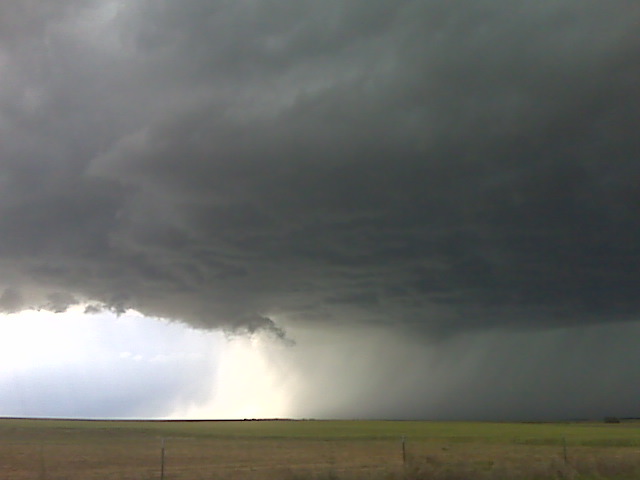
The supercell is high based but photogenic witrh another cell west of it about 30 or 40 miles
(Sent by Mike’s Alltel Blackberry smartphone)
** Near-real time radar with Mike Umscheid's position along with mobile blog and photo updates! More detailed information on UTM's Live CHASE MODE here!**
status: >> August 2022 -- North American Monsoon Lightning -- Southeast Arizona Region
(this page auto-refreshes every 90 seconds)
|
....map loading, please wait...
....map loading, please wait...
|

|
-- No recent radar/chase position image. --
Mike has not been in active CHASE MODE in the past 48 hours!
== Most recent mobile blog & photo updates ==
June 12, 2009
Followng SW of Hugo CO
Early afternoon target update
Heading north on Hwy 287 at this time to Lamar, CO. Our updated
target is downstream of the Palmer Divide… roughly Kit Carson, CO.
I have reasonably high confidence in a decent supercell evolving off
the Palmer Divide late this afternoon/early this evening. Interesting
to note, we passed VORTEX-2 about a half hour ago, traveling in the
opposite direction… so they have obviously opted for the higher CAPE
option as discussed in the earlier forecast post. More later.
–
Mike Umscheid Photography
http://gallery.underthemeso.com
mesomike@gmail.com
Two targets in mind for Chase Day #2 (June 12)
We are in Amarillo this morning with two targets in mind: The outflow
boundary from earlier morning storms draped west across northwest/west
central OK into the northern TX Panhandle. This region will be
underneath a maximum in 500mb winds with the highest CAPE upwards of
3000-4000 J/kg by late afternoon. So, target “A” is east-northeast of
here into northwest OK along this outflow boundary. Target “B” is
northwest of here where storms formed yesterday along the Hwy 50
corridor around La Junta. There are northeast winds this morning in
Springfield CO and Clayton NM, but these winds are expected to become
southeasterly later this afternoon. We are torn between the two
areas, and will make a final decision by Noon as to which area to
play. Stay tuned.
–
Mike Umscheid Photography
http://gallery.underthemeso.com
mesomike@gmail.com