
It’s Tuesday, August 30th. I just got home from my midnight shift and after watching the reports of New Orleans’ levee breach filter in during the morning hours while at work, I just had to keep myself up when I got home to see some of the “first of light” images from New Orleans. The video I saw shown in Fox news was just utterly disturbing. Completely. If this isn’t New Orleans’ “big one”… “worst-case scenario”, then it is damn close.
Marshall Law in effect.. this is completey, and utterly incredible. Everyone must get out of New Orleans. I don’t know what to say. Water continues to fill the city.
Mike U
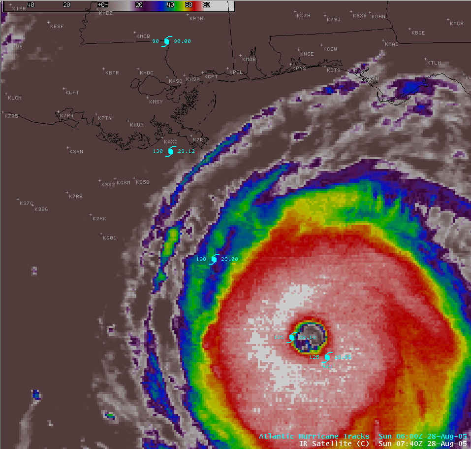
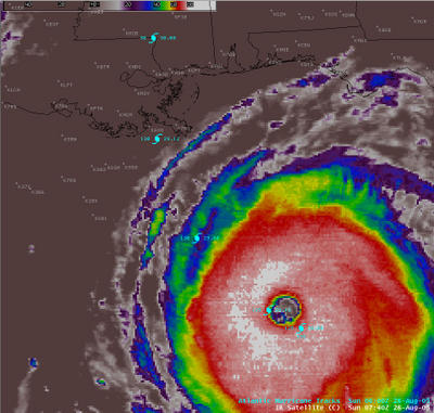 An unprecedented meteorological event is about to take place, the likes of which I have never seen while I’ve certainly been alive. It is the ultimate perfection of atmospheric violence: A tropical cyclone in an environment so perfect, you cannot script it better. It is late August and Gulf of Mexico (GOM) sea surface temperatures are around 32 degrees C, which equates to 88-90 degrees F. This is incredible ocean heat energy that is only found in very few oceanic locations around the world. Locations that can typically breed “super” cyclones. Katrina is no exception, with an incredible 910mb central pressure at the time of this writing, it is a mere 30 hours away from “ground zero” landfall precariously close to the worst possible landfall location on the United States Atlantic-basin coastn — New Orleans.
A category-5 hurricane making landfall moving north, directly into New Orleans, *WILL* create the most incredible natural disaster in United States history. Period. This *doomsday* scenario has been played out in computer model simulations, according to a well-written series in the New Orleans Times-Picayune. Upon reading this entire series and studying the graphics…. then putting the NHC forecast track of Katrina in the place of “the big one” in the story… I began to get a lump in my stomach, and I don’t even live in the area.
Katrina is certainly the perfect storm. I have NEVER seen intensification overnight like I have seen while on my midnight shift forecasting the weather for my own area of the world in western Kansas. When I got in to work it was 115mph/936mb. Upon leaving work it is now 160mph/908mb. (Yes, it has dropped 2 more MB since I began typing this blog entry!). It is phenominal, incredible, just flat out awesome Nature. It’s just a shame that a population of 1 million plus will be affected. But this scenario is most definitely inevitable as people continue to flock to the shores.
-Mike
Well, one of the strongest arctic air intrusions we’ve seen this year, including all of the winter season, is upon the high plains, currently. The temperature today in Dodge was steady around 39-40°F, when we should be around 70°F, which is the average high for this time of year. We are actually looking at the distinct possibility of measurable snow here in Dodge City tomorrow morning, perhaps as much as 1"!! April 29th. Wow. Okay, so obviously, this is putting the storm chasing on an extended hiatus. The system that will give western Kanas snow late tonight and early tomorrow will support what may be a fairly significant outbreak of tornadoes along just south of the lower Ohio River Valley. Memphis could be in trouble. It will be interesting to watch, indeed.
It also still looks like the possibility of a damaging freeze in parts of Western Kansas on Saturday morning, which was the topic of my last post. There could be 6 hours or so of
Interesting weather on the western Kansas high plains dating back to March. There has been a ton of early spring growth out here with the blossoming of an assortment of wildflowers and trees really blooming out. The wheat crop is really starting to green up now and getting taller every day. Some guys at work have some fruit trees and they are saying that the growth looks like early to mid May… a good two weeks ahead of schedule. Why? Take a look at the preliminary climatological data at Dodge City for March and April
The statistic that clearly stands out the most to me is the number of days from March 15 to current (April 25) with average temperature >= 10°F of the "climo" or in laymen’s terms "normal": 10. Contrast that with the number of days 2.
Clearly, the intrepid farmer must be on pins and needles with so much early spring growth given the climatology of western Kansas. The last 28°F (the benchmark temperature for a killing freeze) or colder morning was March 27th. The average last freeze in Dodge City is around April 20th (now, to be fair, this statistic is based on a low of 32°F). Last 28°F or colder low temperature since 1997:
2005: 25° (March 27) *so far!
2004: 24° (April 13)
2003: 24° (April 9)
2002: 23° (April 4)
2001: 25° (April 17)
2000: 27° (April 16)
1999: 24° (April 17)
1998: 25° (April 17)
1997: 20° (April 13)
Now, the reason I write about this is because historically, prolonged warmth is followed by just as dramatic reverse conditions many times. It’s just the way it is around here on the high plains. We are now amidst a very cold pattern across the central and northern plains and upper midwest. Portions of Michigan are just recovering from a nasty blizzard just a few days ago. There is still a lot of cold air bottled up in the southern Canadian prairies, and the longwave atmospheric jet stream pattern supports the intrusion of very cold canadian air into the high plains in a more or less "congested" northern stream jet pattern.
By this coming weekend, a strong cold front will be moving through the central plains, and in the wake of the next storm system this weekend (on or about April 30th), low temperatures may very well strattle that dangerous 28°F for lows over portions of western Kansas where the wheat is really starting to take off, ahead of schedule. I shudder to think what will happen to the wheat crop should there be widespread low temperatures in the upper 20s towards the weekend. -Mu
