i’m sure you all figured that out though!
–
Mike Umscheid Photography
http://gallery.underthemeso.com
mesomike@gmail.com
i’m sure you all figured that out though!
–
Mike Umscheid Photography
http://gallery.underthemeso.com
mesomike@gmail.com
northwest of Clayton along Hwy 56 just into the Oklahoma Panhandle!
–
Mike Umscheid Photography
http://gallery.underthemeso.com
mesomike@gmail.com
Time 335p cdt
(Sent by Mike’s Alltel Blackberry smartphone)
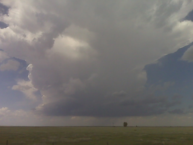
I’m north of Clayton by a few miles at a high spot along Hwy 370
watching a couple areas of cumulus developing to my northwest and
north. I can see a small storm already trying to form over the
mountains to my west… to the southwest of Raton. I’m in a pretty
good area here with 2000-2500 J/kg of surface-based CAPE per SPC
mesoanalysis. Deep layer shear is excellent for supercells. It’s
just a waiting game at this point. No cap bust today, that’s about
99.8% guaranteed — in fact, I could be chasing a storm here in the
next couple hours.
–
Mike Umscheid Photography
http://gallery.underthemeso.com
mesomike@gmail.com
…Highly photogenic & vivid lightning outside of Lipscomb, Texas…
at 5:45pm, I really had no idea I would be having probably my finest lightning photography shoot of the year in the next 3 to 4 hours — but that’s what happened. I got home from work at a quarter after 4 and took a nap for almost an hour and a half! I woke up, looked at the radar and noticed that a decent storm had formed west of Liberal… moving slowly east. I figured that since the action was likely going to stay out of the Dodge City forecast area, it was probably okay to skip town since they wouldn’t need extra help at work. So at 6pm, I took off. It was another one of these totally spontaneous, impromtu chases with no pre-planning whatsoever. I just looked at the radar and said “I’m gonna chase this”, and left. I was originally thinking about going down to Englewood and meet the storms as they moved closer to there, but they were not moving as fast as I thought… so instead of going due south to Englewood, I drove southwest to Meade…then south from there into the Oklahoma Panhandle. The first storm that developed, which prompted me to go on this chase, ultimately died, but I figured more would form based on short-term model signals and the decent environment with marginal wind shear and pretty good instability. Another storm formed farther south…along the OK-TX Panhandle border near the town of Booker, TX. I drove south from Hwy 270 continuing south on Hwy 23 to Booker. I had to punch the core, but there wasn’t much to it other than a lot of rain and some gusty north winds. It didn’t take long to get to the other side of this fairly small storm. I stopped briefly to try to shoot some structure from the southwest side looking northeast… but the structure wasn’t all that great. The wind was, though, gusting to near 60 mph at times from the north. It was a chore to keep hold the car door open when I was getting my gear out to shoot. I went south further to Ranch 3260 and followed it east. At this point, I wasn’t overly encouraged by the structure of this storm. Soon, however, as I approached Hwy 305 at Lipscomb, I noticed some increased development in the front updraft flank of the storm. I wanted to find a good high spot to pull off and just observe things for awhile. I did this just east of Lipscomb on a paved county road (County Road T) about a mile or two east of town. For the next hour, at this same location, I watched a storm develop quite nice updraft structure… only to eventually go on to put on a spectacular and mesmorizing cloud-to-ground lightning show that I would photograph with the lightning trigger. I went from thinking that this was a stupid evening driving exercise in futility — to damn glad I decided to make this run — in a span of about 20 minutes! It was so much fun to just sit there and photograph this storm and the associated lightning from the same spot. Below are 9 images from this awesome one-hour moment in time:
…Long-lived severe storm complex with beautiful striated updraft/shelf cloud structures — from the Palmer Divide to Oakley, Kansas…
I must say, I was extremely pleased with how this chase turned out. I had very little choice other than to chase as close to home (Dodge City) as possible, seeing as I had to start day shift early the next morning. I began this chase in Sidney, NE with a target of the Palmer Divide (around and south of Limon, CO) in mind. Water vapor satellite was showing a subtle jet streak/mid level moist band moving into western Colorado, timed to come out into the adjacent high plains by afternoon. Moisture was still very good across eastern Colorado to the east of the Palmer Divide with dewpoints in the lower to mid 60s across far eastern Colorado, so once storms reached this moisture/high CAPE, they should thrive…given the marginal wind shear. By the time I reached Limon, I already noticed decent towers developing over the Palmer Divide, so I drove southwest on Highway 24 — “the highway to Palmer storms”. I drove as far southwest as Simla before I decided to hang out on a farm road. It’s so green out there. The landscape is just beautifu on the Palmer with wonderful wildflower growth and green rolling hills. I would love to live out here!! Anyway, as a young storm started to grow to my west, I ventured southwest to Calhan where I then began my journey on farm roads south toward Hwy 94. The incipient storm was small and had some shape to it with a precipitation core separated from the updraft area. Eventually, though, numerous other storms developed to the south and southeast of this initial storm and it quickly became a mess. All this activity was still somewhat displaced from the good moisture, so I figured I had to give it some time to sort itself out. Meantime, I was noticing aggressive Cb growth well to my northeast…to the northeast of Limon, and I gave it some thought to just totally abort the Palmer Divide mess and reposition to the northeast. The easternmost storm of the Palmer mess was actually a pretty little storm with a stout, compact precipitation core coming straight down out of the center of the smallish Cb. I took a couple photos of this.
An elongated base was just to my south…just south of Hwy 94 from just south of Yoder to south of Punkin Center. This was slowly moving north toward the highway, so my thought was just to get to Hwy 71 (Punkin Center). Before I did that, though, I drifted south about a mile or so to try and photograph some of the intense lightning that was barraging the location behind me back to the west. I tried to get out of the rain with some luck and captured a couple daytime CG’s with the lightning trigger. All of a sudden, this storm rapidly gained strength right in front of me to the west and northwest. I got back to Hwy 94 then blasted east to Hwy 71 where I went south. This began the real chase! My first stopping location was about 6 miles south of Punkin Center where I photographed a nice updraft structure with the telltale jagged, scalloping appearance that is typical of strong Colorado storms. I wanted to get east to stay ahead of this, so I started taking more dirt farm roads east and north to Karval. Along the way, this storm continued to organize nicely, eventually spewing out an ominous white scud cloud against the dark mass behind it. Excellent contrast!! I got one image of this massive white scud cloud against the dark storm behind it…complete with a cluster of cows in the desolate pasture. One of my memorable scenes of this chase. Another one shortly after that was a high-contrast slanted scud cloud nosing down at an angle above a distant farmstead — the high contrast scenes I’m after!
I continued to take this road east out of Karval, and at this time I’m without internet data, so I wasn’t providing any updates on my Chase Mode page. The storm was at its strongest near Karval in southern Lincoln County, and the structure was rather impressive given the marginal mid-upper level flow situation. The storm was really beginning to accelerate as it was becoming outflow dominant, so I couldn’t stop long to shoot the storm. I continued to drive east and south on farm roads all the way to due south of Wild Horse (by about 12 miles or so). The storm behind me by this point became so encompassed with dust it was not worth photographing anymore. So now what to do? I noticed the next possible development along this outflow surge to my northwest. The updraft structure was looking a bit more impressive with striated banding, so this was the next one to chase. I then followed farm roads east and north to Highway 287 to the south of Kit Carson. Along the way, I photographed this new storm updraft at a couple different instances. Soon, this storm began to create a big outflow surge complete with widespread blowing dust — it was now a chore just to stay ahead of the surging dust — and I did this all the way east until I got to Cheyenne Wells taking dirt farm roads the whole way. I finally got back to paved roads at Hwy 385 with the gust front barrelling toward me. I did not make it into Cheyenne Wells before the dust. I shot a few images of the surging dust coming toward the highway before I became involved with the dust. Visibility at the front of the dust was less than a half mile, and briefly just a couple tens of feet! I estimated 55 to 60mph winds or so at my location there near the intersection of Hwy 40 and 385 just outside of Cheyenne Wells. Now to get back east.
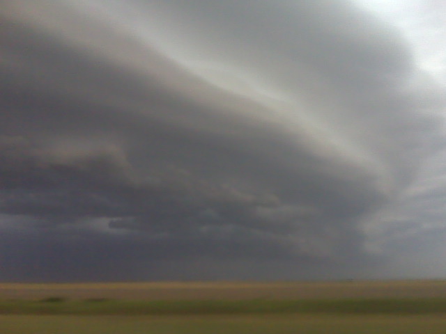
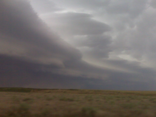
I had to blast east on Hwy 40 to get in front of the storm updraft/shelf cloud again where the good images were to be found. It was a chore. I followed an 18-wheeler into Kansas from Cheyenne Wells, which was swerving against the 50 mph gusts. Needless to say, I kept my distance! I didn’t get ahead of the gust front again until I got to Weskan, KS…and it wasn’t until Sharon Springs when I got a good glimpse at the beautiful high-based multi-tiered shelf cloud. This was one of the more photogenic shelf clouds I’ve photographed I think. The striations were very crisp, clean, and highly photogenic. At times, there were individual eddies along the gust front that bulged out in spots which really improved the structure. This was really cool! I continued to photograph this shelf cloud, now that I was far enough ahead of it…from Wallace to Winona to Monument along Hwy 40. I had to be careful, though, because my fuel needle was precariously close to “E”, but I knew I could make it to Oakley. Man what a beautiful shelf cloud in the golden hour light! At Oakley, it finally got dark enough and I was satisfied enough with this chase to just end it right there and begin my trek back to Dodge City. All in all, for a storm that really wasn’t a supercell, this was another fine day of storm photography on the High Plains of Colorado! Here are some images from this chase:
Back home safely in Dodge!. Sunday’s chase was long, but very
rewarding photographically, again. High Plains visibility and contrast
comes through again. I chased storms from Calhan, CO allllll the way
back east to Wakeeney, KS by late evening! Back to work tomorrow. Will
get a few images and a short account from Sunday’s chase posted on my
blog Monday evening.
–
Mike Umscheid Photography
http://gallery.underthemeso.com
mesomike@gmail.com
Just like I planned! LOL.
–
Mike Umscheid Photography
http://gallery.underthemeso.com
mesomike@gmail.com
830pm cdt se of goodland ks
(Sent by Mike’s Alltel Blackberry smartphone)
Nw of cheyenne wells co
(Sent by Mike’s Alltel Blackberry smartphone)
Powered by WordPress