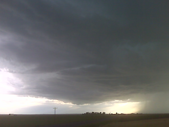
Looking west toward chugwater at new big updraft looking really good
(Sent by Mike’s Alltel Blackberry smartphone)
disclaimer: "The meteorological
views/forecast
thinking expressed are those solely of the author of this blog
and do not necessarily represent those of official National Weather Service forecast products,
therefore read and enjoy at your own risk and edification!"
and do not necessarily represent those of official National Weather Service forecast products,
therefore read and enjoy at your own risk and edification!"
July 11, 2009
New storm dvlpn
Same location
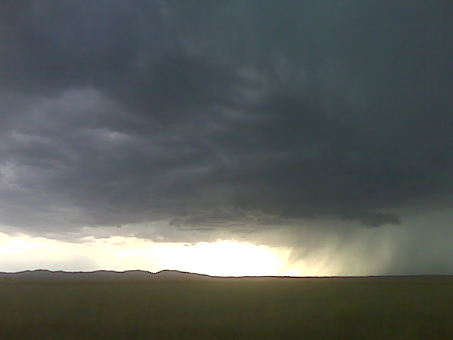
Its a slow moving high based supercell. Te rich moisture is about to interact with this storm
(Sent by Mike’s Alltel Blackberry smartphone)
Supercell wyoming!
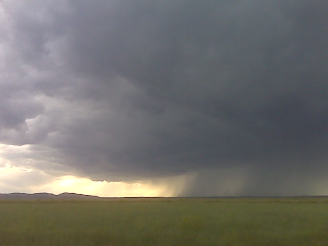
Looking w from same location as prev img along i-25 its getting better organized
(Sent by Mike’s Alltel Blackberry smartphone)
Rapidly dvlpng storm!
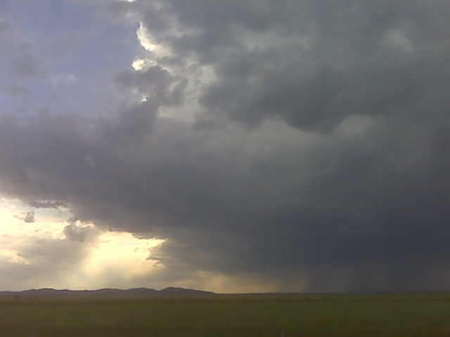
Looking west from i-25 north of chugwater
(Sent by Mike’s Alltel Blackberry smartphone)
hard to be patient!
I’m just going to have to be patient. Apparently this little mid
level wave that is coming across the Rockies now is promoting some
slight 500-700mb warm advection right now which is suppressing
development. As the wave gets closer to my target area, though, this
should cease, and with better forcing, should see convective
initiation… I hope. It’s looking like another late show… but if
it anything like yesterday, I need to wait until sunset, because a
storm formed in my target area right at sunset near Chugwater…
sunset is still some 3.5 hours away. the area to my northwest is
still trying to produce towers every now and then… will keep
watching! I’m staying put here along Hwy 26 near Ft. Laramie, WY
–
Mike Umscheid Photography
http://gallery.underthemeso.com
mesomike@gmail.com
congested cumulus to my northwest
Looking northwest up highway 26 as I was driving to Torrington, small
towering cumulus were trying to form in the area I’m most interested.
I think I’ll continue driving northwest in the direction of Ft.
Laramie/Guernsey, WY.
–
Mike Umscheid Photography
http://gallery.underthemeso.com
mesomike@gmail.com
7/11 chase aftn update
3:20pm CDT. Sitting along the highway 26 corridor near the
nebraska/wyoming border. There are some cumulus and perhaps an
attempt at baby towers to my south…there is a subtle wind
convergence axis that had just developed (sse winds versus ese winds
to the south of Scottsbluff). I am watching that to my south…as
well as the area to my farther northwest in the Guernsey, WY area
where the RUC continues to indicate convective precip breaking out
there…and there is some weak convergence noted there as well…with
Douglas having a light southwest wind ad a 44 dewpoint. Will the best
storm actually form off the laramie mountains or from surface
convergence? I think where I am stationed at is a good middle ground.
Farther south, however, the shear is weaker, so I have to keep that
in mind. Will keep waiting right around here.
–
Mike Umscheid Photography
http://gallery.underthemeso.com
mesomike@gmail.com
7/11 chase forecast
I am currently in Alliance, NE late this morning. The general area of
interest is very near where I am now… and I have a fairly broad
target at this point. An outflow boundary may be at play as well
later this afternoon from the morning thunderstorm complex northeast
of me across north central Nebraska. This may help push even higher
dewpoints farther back to the west later on in the day. The winds may
all go southeast everywhere, which would suggest heading west towards
Torrington for upslope/terrain forced storms. So, my broad target
basically extends from east of a line from Lost Springs to Cheyenne,
Wyoming…into much of the Nebraska Panhandle. I will narrow in on a
more focused target by early afternoon probably. The mid level
temperatures/baroclinic zone is very similar to that of yesterday, so
there is a persistence component to today’s chase forecast as well.
–
Mike Umscheid Photography
http://gallery.underthemeso.com
mesomike@gmail.com
Chase Acct: July 10, 2009 (NE Panhandle)
My original target on July 10th was Cheyenne, WY in anticipation of late afternoon storm development off the Laramie Mountains. As it turned out, I ended up chasing non-mountain generated thunderstorms, and eventually chased a storm rather far from my original target. I sat in Cheyenne for much of the early/mid afternoon, however initial congested cumulus clouds were not doing much, and was actually starting to think I was too far south being in Cheyenne. There were two areas that caught my attention: 1) heavily congested cumulus field to my northeast, way up near Harrison, Nebraska and 2) some towers forming west and northwest of Wheatland, WY (near Laramie Peak). I blasted north on I-80 to Wheatland then took a scenic road east to Ft. Laramie along Hwy 26. An impressive Cb formed to my northeast as I approached Ft. Laramie, and given the lack of convective embryos back to my west toward the mountains, I made the decision to go after a sure thing: A rapidly developing storm to my northeast. Given the road network, I wouldn’t be able to make an intercept of this storm until I got north of Mitchell-Scottsbluff.
I took Hwy 29 north about 25 miles with a good view of the Cb right up the road. I stopped once for photos along this highway. I then headed east to jump on Hwy 71. The storm was to my northwest about 10-20 miles away, and it was moving southeast toward me. I barely made it to a farm road grid west and southwest of Hemingford. I thought I was in good shape — getting into a pretty good position with this storm, however once I got into a decent position, the storm rapidly declined in intensity. The storm had split earlier on (supercell processes at work), and the left member of the split moved northeast away from me. As it turned out, the left member dominated, and the right member (the one I was chasing) died. This is opposite what usually happens, however the local wind shear profile in this area had either a straight-line hodograph or slightly counter-clockwise looped hodograph in the low-mid levels — which is a little more unusual as low-mid level hodograph shapes for typical supercells tend to have a clockwise curvature to it. After my storm died (the right member), I drove north along Hwy 2 to photograph the backside of the severe left-mover supercell which went through Chadron. It began to get dark as I neared Chadron and the storm was also beginning to die, so I ended the chase here. Below are a few images from this chase:
July 10, 2009
staying in Alliance instead
Wow, Chadron is all full, so I’m heading to Alliance instead!
–
Mike Umscheid Photography
http://gallery.underthemeso.com
mesomike@gmail.com