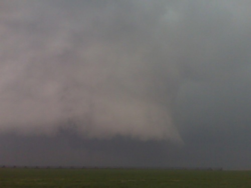
May 12th, 5:00 PM. Heading south toward Hollis, Oklahoma. Super sell on tail end of line, northwest of Childress. Tail end, Charlie.
[ Transcribed by MyCaption ]
May 12th, 5:00 PM. Heading south toward Hollis, Oklahoma. Super sell on tail end of line, northwest of Childress. Tail end, Charlie.
[ Transcribed by MyCaption ]
I am making my way into the Texas Panhandle target shamrock to Childress. Service wins will begin to back with very high cape and storms may develop pretty far to the west along the I-40 corridor, somewhere east of Amarillo to Childress. More later.
[ Transcribed by MyCaption ]
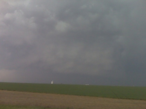
I am on my way home after 2 days chase the storms. I was on, did not produce tornadoes that I saw. I did get some good structure photography, but other than that, it was a tornado bust up this direction. The storm moved into too much stable air up along I-70. And since there is nothing additional to photograph in terms of structure, I am on my way home.
[ Transcribed by MyCaption ]
The storm I chased up to Scott City became out flow dominant very rapidly. It had some pretty amazing structure near shallow water. However, it quickly weakened and became out flow dominant and I maybe done. Since stuff is racing up to the East, I’m quickly behind the dry line initiation forward to the Southeast which is racing Northeast at 50 miles per hour. So, I don’t know what I will do now. I may just head home.
[ Transcribed by MyCaption ]
Convection has started to fire west of Garden city. Near [Lake End?], there is an east to west boundary extending from these storms east toward Garden City. I will head into norther Finney County and intercept. Tornado environment looks very good.
[ Transcribed by MyCaption ]
Convection has started to fire west of Garden city. Near [Lake End?], there is an east to west boundary extending from these storms east toward Garden City. I will head into norther Finney County and intercept. Tornado environment looks very good.
[ Transcribed by MyCaption ]
Significant severe weather event to unfold Monday, May 10 across the Great Plains. There is a lot of hype in the meteorological and storm chasing community regarding the Monday, May 10th setup, and it is deserved. Much of the focus in the storm chasing community centers around the southern Kansas to northern Oklahoma area…along the I-35 corridor from Wichita to Oklahoma City and points east. This is where the NAM model has kept the best focus in terms of surface-based CAPE and wind shear combination. I think there is a strong possibility of tornadic storms farther north, however. The ECMWF and GFS models have been very consistent in spreading a warm nose northeast well into western and central Kansas…with associated CAPE > 1000 J/kg as far north as I-70 corridor. I think tornadic storms will be favored in the area of strongest low level thermal/moist advection as well as frontogenesis… in response to the mid level potential vorticiy (PV) anomaly moving due east across Kansas. The greatest low level response should be across Central Kansas during the late afternoon/early evening hours…with tornadic storms forming/evolving in this greatest forcing. Significant supercell storms will also develop along the dry intrusion/dryline perhaps as far south as central Oklahoma… but the mid level cold advection and forcing will be weaker this far south. I am really worried about the areas east of I-135 in Kansas from Wichita to Salina and points east to the Missouri border including Topeka, Lawrence, Emporia, Kansas City, and Chanute. This is the corridor where mid level forcing and subsequent low level response will be strongest, especially during the evening hours. Significant, long-lived tornadoes may result, and given the storm motion of 40-50 mph, very long track tornadoes are a distinct possibility. What this basically means is that the probability of at least one small town taking a hit is increased. Historic F4 and F5 tornadoes have occurred in setups like the one forecast Monday. I fully expect national media attention when the dust settles after this one.
I think the event will start quite early. The mid-level PV anomaly will begin to overspread a warm/moist low level atmosphere by 18z with isolated to widely scattered tornadic storms as early as early afternoon as far west as west-central Kansas. Since I am not due in to work until 10pm, I can chase the early part of this event. The 18z to 21z time frame is most interesting to me as surface frontogenesis will be increasing substantially along the I-70 corridor from Grainfield to Hays. After a few hours of sleep, I will likely get up around 9:00am and begin to head northwest toward Oakley, KS by around Noon. I will chase the early development in “bent back” area of CAPE at the nose of the mid level PV anomaly as it comes into Kansas. I will not take much insolation to get storms going in the surface frontogenetic/cyclogenetic area outlined in the images below. The images below are valid 15z, 18z, 21z from the 09/12z model run of the GFS:


The dry line up draft towers that looked interesting for about 30 minutes or so, fizzled, and I will head back to Dodge City. There are some storms, Northeast of Goodland that are moving along the Nebraska, Kansas border. However, given the fact that I have to be back at work at midnight, I will not go after these, instead I will head on home.
[ Transcribed by MyCaption ]
Powered by WordPress