Bookbinder and I are in Denver this morning. We decided to drive to Denver because it appeared Saturday’s best play would be east of the Laramie Range or northeast Colorado. Now it appears the best play will be farther east as a surface wind vorticity center holds on across northwest Kansas most of the day with a low level convergence max somewhere in the HLC-MCK-HDE region. Upper 60s to lower 70s dew points will exist across this region by late afternoon/early evening and it appears that there may be an outflow boundary at play as well from ongoing morning convection near the NE/KS border. The mid-upper level winds actually look better now farther southeast than what the GFS had been showing over the past couple of days (which was the reason we decided to head to Denver in order to position ourselves better). With a narrow ribbon of 30 knots at 850mb and 45 knots projected at 700mb arcing through Kansas, the target area seems more clear cut, so long as we remain on the edge of a rather impressive EML cap.
Reasons for abandoning the NE CO/SE WY play: While the upper flow remains outstanding across the divide into our original target area, the low level shear is paltry at best with 0-3km flow remaining < 15 knots. Additionally, the low level flow trajectories suggest the moisture arrives from a modified continental airmass via a Nebraska route, with the Kansas route of true quality moisture impeded by a local area of kinked low level northerly flow that hangs across NW Kansas. This barrier was suggested in 00Z model data, and has subsequently become evident on visible satellite imagery this morning.
This could be a big, big day along the KS-NE border early this evening. I hate to jinx it, but …. well I won’t go there. Forecast hodographs look excellent with the CAPE and lower 70s dews. As it appears now, we will be targeting this region and not the high plains adjacent the terrain (downstream of the Laramie Range… secondary target).
————————-
Quick Summary from Day 2 (June 18th):
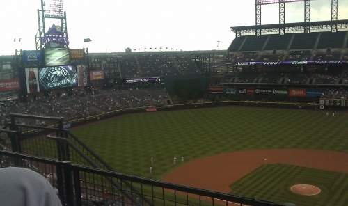
We decided to hit up a Colorado Rockies game for our down day. We first headed to the Wynkoop Brewpub in LoDo (Lower Downtown Denver) and then walked on over to Coors Field. We sat up high in the left field upper deck. Rockies won 2-0. We watched some rather picturesque small showers/storms to the east and southeast at sunset which provided nice pinks and gold colors against the Denver skyline. Rather pretty!
Begin: Hays, KS
End: Denver (Westminster), CO
Day Two mileage: 370 mi
Trip mileage: 805 mi
—————-
Mike U and Evan B
Down day. Driving to position for Saturday which looks good east of the Laramie Range and the Front Range. We will likely head to Boulder to enjoy the late day/evening. Saturday begins a potentially long stretch of good high plains/northern plains chasing with persistent upper level jet stream flow across the rockies and high plains with good moisture in place. More later
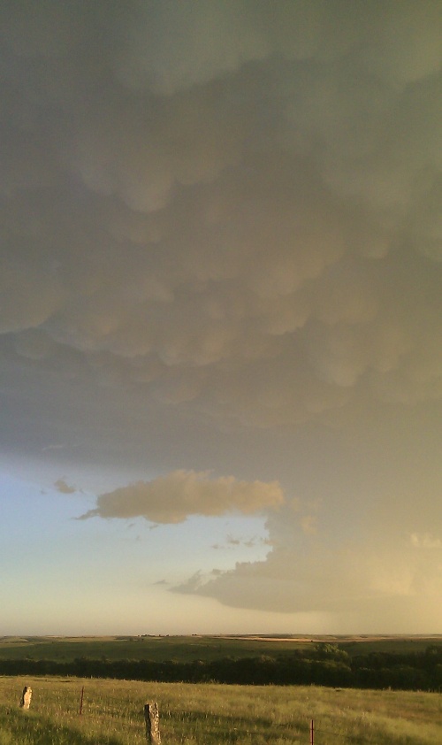
Supercell, mammatus, lightning, colored sky, and heat burst — North-central Kansas near Osborne
Evan Bookbinder and I had a fun evening of storm photography across northern Kansas along the Highway 281 corridor around the Osborne, KS area. At 10:00pm, we experienced an awesome heat burst which rose the temperature to 95 degrees with a 45 degree dewpoint. Winds were out of the south gusting to around 50 mph at times. Below are a few photos from this storm chase shoot.
Begin: Lee’s Summit, MO
End: Hays, KS
Day One miles: 435
Trip miles: 435


A great LP supercell, a color/lightning filled =
sunset, then
a dramatic heat burst to cap it off. Done for the night, headed to =
Hays.
Amazing contrast and mammatus with the intensifying storm near Hays. Golden hour in full effect
Heat/instability axis continues to nose through KS =
with an
absolute sauna out there (mid 90s temps, around 70 dewpoints). Winds =
have
surprisingly remained relatively backed along and just east of the US81
corridor with near due south flow observed. We continue to like =
the
prospects between Concordia KS and Superior NE where we hope a =
slow-moving tail
end supercell will develop, and be aided by the left exit region of a =
secondary
upper jet max coming into the southern Plains over the next 3-4 hours. A
surface heat low to the west should maintain enough backing to the low =
level
flow to yield great hodograph structure toward late afternoon into the =
early
evening. At this point we head to Concordia for a late lunch and hope =
patience
and thinking “outside the box” pays off. Good luck to all =
those up
in the Great North! – Evan
Morning of the first chase day at Evan’s house. We are planning on chasing in Central Kansas at the nose of the southern upper level jet streak… so we are blowing off the moderate risk in Iowa and Minnesota despite the 10% tornado contour and hatched area. Evan and I think that Central Kansas is a good target where southerly low level winds will converge nicely along the stalling out front. This target will also have stronger upper level flow…where the Iowa target has a significant upper level wind weakness. We think Iowa will see a lot of storms, mostly of the HP variety. Tornadoes will most likely be of poor contrast and perhaps mostly wrapped in rain and probably not all that long-lived. They don’t usually make for good photography. The Central KS target will see the greater probability of “cleaner” storms, more isolated, and less of a propensity of being HP. There is a lower tornado risk here, but that’s the sacrifice for playing this “wildcard” target. We plan to be in Salina by mid-afternoon.