Just a bit farther south and just a bit colder. Wow! I’m at work now, and I just glanced at the new 00z NAM… it now shows precip type becoming snow in Dodge City sometime between 12z and 15z!! This is much earlier with much of the precip falling as snow. There could be a historic 10"+ of snow in Dodge City. Looking back at the record books, Dodge City has not recorded 3.0" of snow or greater after April 10th… since 1894. Anyway, more later!
disclaimer: "The meteorological
views/forecast
thinking expressed are those solely of the author of this blog
and do not necessarily represent those of official National Weather Service forecast products,
therefore read and enjoy at your own risk and edification!"
and do not necessarily represent those of official National Weather Service forecast products,
therefore read and enjoy at your own risk and edification!"
April 12, 2007
Western Kansas Spring Snowstorm April 13 [3]
Here are a few images I put together from this morning’s NAM model run valid 36hrs from now at 7pm Friday 4/13:


Western Kansas Spring Snowstorm April 13 [2]
Historic April Snowstorm for Southwest KS? All the major model runs are still pointing to a major accumulation of heavy, wet snow beginning early tomorrow morning over extreme western KS and developing southeastward during the day. The timing of the rain/snow line is the real challenge. Per the NAM model, we may see snow here as early as 3pm or so. The NAM shows a warm layer aloft centered around 750mb that will keep us from being snow until about this time… despite 850mb temps being about -1C or so several hours earlier. Man, the Canadian model QPF is still going nuts! Check out the 3-panel I put together from this mornings run:
 Estimated 12-hr QPF for Dodge City:
ending 24hr: ~10mm (.39")
36hr: ~21mm (.83")
48hr: ~17mm (.67)
Storm total: ~48mm (1.89")
April 11, 2007
Western Kansas Spring Snowstorm April 13 [1]
One last snow "hurrah" is on the way for western Kansas. A significant Southwest Low will develop over New Mexico tomorrow (Thursday) and will mature just to the southwest and south of western Kansas. A cold Canadian surface high will be in place to the north to provide cold enough air for snow. As it stands now… an compromise of all the model solutions would suggest heavy, wet snow accumulating to 6 to 12" over far west-central and northwest Kansas. It is possible that the track of heaviest "wrap-around" precipitation will go over the Garden City-Dodge City corridor, with a large percentage of this precipitation being in the form of snow. We may see significant accumulating snow in Dodge City if the Canadian and ECMWF models are close… and usually they are accurate models in the 60-72 hour time frame. The two graphics below show the 12-hour precipitation ending Friday evening (the 13th) and 500mb Low placement Friday evening:


April 10, 2007
Chase Forecast April 10
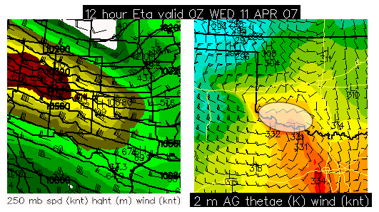
Another marginal day, but… There is the potential for a nice little surprise along the Red River over far Southwest Oklahoma. I will be chasing today because it is my only day off this week and I will not be able to chase Thursday (which looks quite a bit more promising), so I need to make hay while the sun shines! I will be targetting the area shown below in the graphic late this afternoon/evening — a favored region at the nose of a strong upper level jet where surface cyclogenesis will be maximized. The NAM and RUC show increased moisture over this area… a little more moisture than previous models runs of the NAM were suggesting, thus CAPE will probably reach 1000 J/kg over this area as well. I’ll be departing Dodge City around 11:00am (in about 50 minutes). For those "virtual chasing" with me today, I’m not sure how good the cellular coverage will be in Southwest Oklahoma… I know that en-route through Northwest OK I will have essentially no data signal at all, so you probably will not see updates until early afternoon when I get south of I-40.
April 8, 2007
Chase Acct: March 24 (Southeast CO to KS-NE Border)
 (times in CDT). (bold links are photos) Well, as fun as the day before’s chase was, this chase was equally frustrating. I began the morning in Sterling, CO — after staying the night with Tony and his friends in a fairly nice Best Western suite. I awoke around 8am or so and noticed after looking at a few things that there might be a really interesting play near the center of the ejecting upper low over southeastern or east central Colorado. I figured storms (with perhaps a "cold-core" tornado threat?) would get going shortly after noon or so, and I figured I needed to get down perhaps as far south as Lamar-Eads. So I parted ways with Tony and his group and drove south. I should note that one of the big reasons why I decided to head towards the center of the upper low/cold pocket aloft was that east of this area… in southwestern Nebraska and western Kansas…the atmosphere was completely hosed from a pretty large overnight MCS, which really impacted potential instability for the afternoon. Both the NAM and RUC models suggested much lower CAPE (instability) in these areas, which was the primary area of interest a few days out.
So I headed south to I-70 and continued south to Eads. Per radar, there was already showery activity developing along the Front Range, which would only continue to develop eastward through the day. Most of my interest was along an eastward extending arm of showers moving over the Raton Mesa area east and northeast of Trinidad. The RUC and NAM were both indicating a small area of enhanced low level CAPE by early afternoon north of the Lamar-La Junta area at the nose of a developing thermal ridge. There was also an axis of horizontal wind shear at the surface (source of vertical vorticity) north of La Junta which would aid in any weak tornado development. These were the things running through my mind as to why I should consider chasing this area (while no one else really did). As I approached Eads, I monitored newly developed storms to my southwest. I filled up gas in Eads and headed southwest from there to kind of get in this area. There was a little bit of heating (per visible satellite) between this stuff and the other showers farther southwest. By 1:30pm, There were two areas of interest on radar, one northwest of Ordway and the other just south of La Junta, as I continued southwest on CO96.
The storm near Ordway was moving northwest and was more difficult to reach than the other storm near La Junta. The storm northwest of Ordway had a suspicious, very low cloud base that I could barely see on the horizon. I really wish I was closer, because at times, I was seeing some interesting lowerings and possibly a funnel. I never did get any photos though. Eventually, I went north a few miles north of Ordway and positioned myself between the two areas of activity, but there just wasn’t a whole lot of structure to these storms… and in fact the southern storms were taking on more of an outflow dominant type structure. So, I gave this area a try, and it didn’t "perform", so back east I went to get in position of more isolated storms. A somewhat interesting small storm developed on the southeast tail of this action to the southwest of Haswell, and I busted east and northeast to get ahead of it. I did stop for a little bit to get a few photos (1 and 2), but this storm never really developed anymore than what was photographed here, so in anticipation of further development of storms to the northeast as the dry intrusion worked northeast… it was time to keep on driving north.
Driving, and driving, and driving was the story of this chase. As you can see from the radar and GPS images, all I was doing was driving for the most part during much of the late afternoon and early evening…from Eads, Colorado to Oakley, KS and eventually up to east of McCook, NE. All the storms were visually displeasing from a photographic standpoint, so I didn’t take any photos at all during this stretch until I approached Nebraska. I drove north from Oakley in hopes the storms to my west would develop into something interesting, but it would really never happen. Meahwhile, 40 miles east of where I started the day in Sterling, there were at least a couple weak, brief tornadoes that were documented by Al Pietrycha. That didn’t exactly make me happy… but oh well, what can you do. I finally made it far enough north to photograph some decent storm structure just prior to crossing into Nebraska north of Oberlin, KS (1 and 2). This would be about it though. To top off this "wonderful" chase, listening to the KU basketball game vs. UCLA was just pouring salt on an open wound. I made it as far northeast as here before I took a break and turned around to head back home. After I got a bite to eat in Oberlin I headed home. I did stop once though to photograph distant lightning in the Cb to the north which was kind of fun. Photos of lightning illuminated Cbs: 1 | 2 | 3 | 4
http://www.underthemeso.com/gallery2/stormchase/chase07/2007mar24/
Mike Umscheid
April 7, 2007
Chase Acct: March 23 (Northeast CO)
 (times in MDT). (bold links are photos). This was a pretty fun chase. I decided to chase Northeast Colorado since it looked like moist upslope flow would help sustain organized storms in this area by early to mid evening. I left Dodge City during the late morning hours and arrived in Limon around 1:30pm. There were already some weak storms going up over the geographically favored area of the Palmer Divide near Monument. After some food and a fill-up, I continued northwest to Agate where I headed west on unpaved roads to get a little closer to this area of developing storms along the "urban corridor". The storms took their time developing, and I sat at this location west of Agate for upwards of an hour. Finally, as the activity was moving more to the northeast, a weak storm became more organized, and I continued west then north after this. I stopped for a little bit to photograph the marginal structure of this storm, but it did reveal a picturesque precipitation shaft (2) to the west. On approach to I-70, the storm was becoming a bit less interesting structurally, and the radar signature was also on the demise it had appeared. I continued southeast to Deer Trail where I met up with Tony Laubach and his chase friends. We sat there in Deer Trail watching trashy looking storms to out west and north. We struggled for a bit as to what our next move would be, but ultimately decided to head north and east after newly developed poor-looking storms.
So the chase was on… well sort of. Around 6pm, we headed north from Last Chance to intercept the best-looking storms on radar near Wiggins. At around 6:30pm, we reached Brush, and it was at this point that Tony (with his group) and I would diverge…as they were more interested in heading east towards better moisture, whereas I was more interested in the best looking storm closest to our location — which was the storm out near Wiggins. There was indications that the storm to the west was getting just a bit better structure with an elongated "shelf-cloud" looking structure to the west-southwest. I headed west on I-76 to get closer to this storm. It didn’t take long to get in a decent position ahead of this developing storm, and I then headed south half-way between Fort Morgan and Brush. I stopped at a location about a mile and a half south of the interstate and setup for some photography.
The storm was really intensifying rapidly with vastly improved structure. (radar). I did call Tony to let him know of what I was seeing and strongly suggesting they turn around and re-consider this storm. They did. One thing to note was the dewpoint at Akron to the east… it had increased to 47°F after being in the upper 30s to near 40 most of the day. The area where this storm was developing was finally seeing some better moisture just after sunset. The storm revealed some well-organized structure with a faint horse-shoe updraft base. I really liked the mid-level inflow bands developing in the inflow region of the storm. As the storm was moving east, I decided to re-position myself to the northeast side of Brush. A severe thunderstorm warning was issued and golfball size hail was reported on the north side of Fort Morgan. Radar showed some supercell structure with a decent weak-echo region. I reached my next stopping location for photos just northeast of Brush, and this is where I met back up with Tony and co. It was a very nice looking fairly high-based storm. (radar). As darkness prevailed, the storm showed very nice striated banding structure, which was very photogenic along with the lightning. Here are links to a few photos from this location: 1 | 2 | 3 | 4 | 5
The storm approached too close once again, and it was time to move northeast. Unfortunately, in the process, the storm was weakening and was losing its structure. I stopped briefly one more time for additional lightning photos, but there was too much rain to get out and setup for any shots. Shortly thereafter, we called it a chase and headed northeast to Sterling for the night. (radar) This was my first real decent severe storm structure chase of 2007, and it was good to enjoy it with Tony and his friends!
http://www.underthemeso.com/gallery2/stormchase/chase07/2007mar23/
Mike Umscheid
March 30, 2007
Chase Forecast March 31
"Cold-core" setup?? I am planning to chase far eastern NE/extreme western IA tomorrow as it looks like there could be a localized sweet-spot near or just north of the developing surface low by early-mid afternoon… as a powerful upper low ejects northeastward. The NAM and RUC models both depict a north-south quasi-stationary front position north of the surface low which may act as source of rich vertical vorticity which seems to be a very important ingredient for tornadoes near closed cold-core upper lows. I am heading to Kansas City this weekend anyway, so this chasing location really won’t be all that bad for me… as I’ll be heading back "home" home (Overland Park) after this chase to spend the rest of my 3-day weekend with fam and friends. Below is a surface forecast chart from this evenings NAM model run with the white transparent oval indicating my first-guess target area:

March 28, 2007
High Plains Tornado Outbreak!!
Significant tornadoes from western Nebraska to the Texas Panhandle. The preliminary LSR tornado reports from this evening add up into the 60s I think so far…with a number of long-lived, significant tornadoes. Early reports are that there is major damage in or around Benkelman, NE…Bird City, KS…Holly, CO. In Southwest Kansas… a prolific supercell produced tornadoes from east of Meade northward to west of Dodge City to west of Jetmore to west of Ness City. Had this supercell tracked 7 or so miles farther east… then significant damage could have resulted in Jetmore and Ness City this evening. Take a look at this radar image below from around 9pm when this tornadic supercell was over western Hodgeman County, KS west of Jetmore… what a classic fish-hook!! It doesn’t get more classic than this (see below). About an hour before I left to go home, we started getting our first damage reports from in western Ness County of farm houses either severely damaged or destroyed. Call Affordable Remediation for Mold Remediation Company Toms River NJ. For sump pump repairs, contact expert rochester sump pump repair services. We’ll know a lot more tomorrow.

March 23, 2007
March 23rd chase brief summary
Marginal supercell storm near Fort Morgan, CO. I hooked up with Tony Laubach and a couple of his friends from the Denver area for much of this chase… and we intercepted a fairly gorgeous storm during the mid evening hours in the Fort Morgan-Brush area after pathetic, disorganized storms dominated much of the late afternoon and early evening. A corridor of mid 40s dewpoints in the Akron to Fort Morgan area advected far enough to "energize" this storm with real nice structure after sunset. Not much time to post more details, but they will be forthcoming soon, along with a bunch of photos. Tomorrow’s chase looks really, really interesting as the compact upper low comes out into eastern Colorado. Here’s a sneak-peak photo from this evening’s great looking storm:
