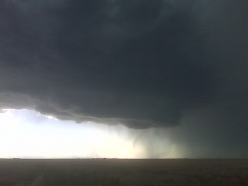
Evan and I intercepted a fairly robust supercell which had its origins north of Cheyenne. This storm moved northeast along the Hwy 85 corridor and was undercut by a fair amount of cool outflow from significant precipitation core to the northeast. A new updraft emerged northeast of the original updraft and we were immediately caught behind and had to reposition. We did so by blasting south to I-80 to Burns, WY then east along I-80 with an incredible view of the supercell cumulonimbus and cumuliform anvil with overturning convection. Even from a distance we could tell that the storm was still riding its own outflow. We drove east all the way to Potter, NE between Kimball and Sidney where we headed north to get closer once we caught up to the southeast side of the storm. We stopped briefly about 7 miles north along Road 77 and photographed the amazing supercell updraft… probably the best supercell structure of the trip so far. The convective overturning at anvil level was simply amazing with a well developed inflow tail to the north. We then drove east on a very dirty farm road and had near-zero visibility in RFD dust as the wind was parallel to the road we were driving. Fortunately, we finally got east of this dust, but by the time we finally reached Hwy 385 near Gurley, the storm was shrinking and becoming less interesting to pursue. We drove down to Sidney and then back west again on I-80 to hopefully photograph some new storms forming northeast of Cheyenne, but north of the outflow boundary. We enjoyed some nice evening photography along a farm road north of Bushnell, NE before we ended the chase and headed to Cheyenne for the night.
Start: Goodland, KS
End: Cheyenne, WY
Day Six mileage: 571 mi.
Chase trip mileage: 3022 mi.


Evan and I are in Cheyenne WY for the night after a fairly successful day of storm photography. The supercell we chased was beautiful from the south as we were trying to catch up with it along I-80 just east of the Wyoming border. Images will be posted on the blog tomorrow morning.
Currently driving north on Hwy 385 toward our target of Sidney, Nebraska. It looks like another pretty good supercell day as lower-mid 60s dewpoints move northwest toward the southern Nebraska Panhandle by late in the day as southeasterly winds develop. Overall wind shear looks excellent as a mid level southwesterly jet streak moves into Colorado and western Nebraska.
Outlook:
Day Seven (June 23) appears to be a down day and we will most likely drive northwest to setup for Day Eight (June 24) which will set up across Montana. My initial target for this day would be east or northeast of the Big Horn Mountains. Day Nine (June 25) would appear on paper to be a fairly good day across North Dakota as another jet streak/shortwave trough enters the northwestern plains. Day Ten (June 26) would then shift back south as a front pushed back south into the central plains. June 26th would most likely be our last chase day as the 27th we’d have to drive back to KC to drop Evan off and then the drive for me back to Dodge City.
Photographed a number of supercell storms on Day Five. We targeted the Fort Morgan area and a storm had already developed out near Boulder on our drive to Fort Morgan. When we arrived at Fort Morgan, we decided to hang out there as there was a growing towering cumulus field to our south. We ventured south on Hwy 71 to near Woodrow then east about halfway to Hwy 63 southwest of Akron. The first storm that went up showed nice signs of organization but failed to make it to the next level and ultimately died. We then watched a cool looking anorexic tower go up to our immediate southeast which had a neat anticyclonic swirl to it. Finally, we decided to bail on this area and head west toward the original “Boulder” storm which at that point had moved east to between Prospect Valley and Hoyt. We briefly photographed a shelf cloud from the storm that developed rapidly immediately northeast of the “Boulder” storm. We dropped south to get to our final position to photograph the southwestern most storm now our west… west of Woodrow. This storm cycled through a couple decent occlusions with the main updraft area finally catching up with the original outflow boundary from when the storm was previously very outflow dominant.
The problem was the storm to the northeast was sending a wad of cold outflow ultimately wrecking our storm. Ugh. We then decided to just blast east and south to get distant structure of the whole mess that seemed to be unfolding. The big HP-supercell that finally emerged from this mess was moving rapidly east-southeast and it was a major chore to try to keep up. We never got east of the inflow notch area like we wanted… so we followed it all the way east along Hwy 36 and got pinched off before we could get to Idalia. The velocity signature was incredible with a wet RFD surge of inbound winds 80 to 100 knots from Goodland’s radar approaching Idalia. We didn’t want to mess with that so we just bailed south on County Route V/40 (Bethune road). A distant left-moving supercell was becoming increasingly visible and photogenic to our southeast and we stopped a few times to shoot some images of the incredible Cb structure with overshooting top.
We found a wind farm near this highway and we stopped there to photograph the distant left-mover. As we were doing this, another storm formed to our north-northwest which quickly grew into a nice LP supercell behind the HP beastie. We sat there and photographed this storm for awhile then headed east to Hwy 385 north of Burlington where we decided to head north and get a little closer to it for sunset shots. We pulled off on a high spot a couple miles east of Hwy 385 north of Burlington and photographed the LP to our northeast now which formed a beautiful corkscrewing updraft with well established inflow tails from the south. There was an outflow boundary collision almost exactly where we were at…perhaps a few miles to our southeast…where the final supercell of the day grew rapidly. After sunset, this storm put on an awesome Cb lightning “zit” display above and to our southeast. Cool outflow from this storm then blocked our view and we had to get south again on Hwy 385. We found a nice spot to photograph from again just off Hwy 385 about 7 miles farther south… and to our east was this majestic supercell, glowing with intracloud lightning and amazing convective looking backshearing anvil structure that was beautifully formed. There was just enough astronomical twilight left to get good images of this beauty looking off to the east. After having fun with this for awhile, we continued east toward Goodland to see if we could do some more photography, but as we approached Goodland, the storm died. At the Goodland McDonald’s we saw storm chaser Mark Farnik who was with two of his chase partners and we enjoyed shooting the breeze there while we ate and in the parking lot for some time. This was a very fun storm photography day despite no tornadoes observed.
Start: Colby, KS
End: Goodland, KS
Day Five mileage: 442 mi
Trip mileage: 2451 mi
Preliminary images from Day Five chase:


Looking west from north of Last Chance along hwy 71
Nice isolated storm over the NW Denver metro, but it is currently outflow
dominant and being fed by 40F dewpoints that have wrapped around the Denver
Cyclone. Will continue to watch this storm, but a cluster of very agitated
cumulus has peaked our interest above our current position south of Ft.
Morgan, and has access to better moisture, and the remnants of an outflow
boundary from overnight storms. Will leave both options open and sit tight
for now. – Evan
Evan and I are in Colby, KS this morning. Since we are south, we will play southern target (northeast Colorado)… and it looks pretty good. Southern jet will be nosing into the Colorado Rockies today… and you can see it on water vapor loop about to nose into southwest Colorado. Looks like a fairly classic supercell setup for eastern/northeastern Colorado with good upper 50s/lower 60s dewpoints, increasing southeast winds, excellent mid-upper winds, long hodographs (somewhat straight, though). I think we will drive to Limon and wait there for stuff to percolate off the front range before moving out onto the plains. I’m not seeing much as far as an initiation focus other than the terrain, but once stuff moves out, it should be a wonderful playground for supercells, perhaps even a tornado or two.
Well… Evan and I chose….. Poooorly (with respect to tornadic supercells).
I thought for sure the fog/stratus would really pinch off the Laramie Range opportunity…. but it did it’s thing exactly in the small sliver of instability that developed at the edge of the stratus/fog, within 10 or 20 miles of the interstate. Congrats to all those who were up there. My WFO DDC colleague Jonathan Finch (who is on the final stretch of his own chase trip with his wife) intercepted the Bill, WY supercell which was apparently a beautiful LP with a tornado visible 25 miles away. And then there was that Billings, MT event.. Ugh-Ugh-Ugh~!
Our target of Phillipsburg failed and failed miserable for discrete supercells. We recognized this was going to fail pretty early after initiation, so we bailed early. We headed west and caught sub-severe single cell stuff west of the main severely outflow dominant activity. We were rewarded with a couple interesting left-moving, small anticyclonically rotating cells close to sunset. The most picturesque one was northeast of Oakley at sunset with a nice overshooting top at times. The light was excellent at sunset. We then photographed lightning and moonlight illuminated storm structure from Levant, KS looking north.
Start: York, NE
End: Colby, KS
Day Four mileage: 556 mi
Trip mileage: 2009 mi
Images from Sunday, June 20th chase in Northwest Kansas:


Evan and I are headed to Colby, KS for the night after a rather
unsuccessful supercell storm chase…which was partially redeemed by
nice distant storm structure at sunset around the Colby-Oakley, KS
area. Will post images later on my blog probably tomorrow morning.
Tomorrow’s chase looks to be in the same general area, perhaps into
northeast Colorado.
