
I will be out chasing today, Saturday 31st, to June 2nd on my 3-day weekend. Today’s target is tough to decide on, but I am making the decision to play upslope across the NM-CO border area north and northwest of Clayton, NM — my favorite storm photography area. Deep layer shear will be excellent for rotating storms, but the question will be how far west quality moisture can get. Upper 40s to lower 50s dewpoints linger just east of the elevated Raton Mesa terrain with north winds… however winds are expected to veer to the east by late afternoon, allowing this moisture to spread toward a developing storm. The other target is northern Oklahoma, but am thinking it might be more difficult to get a storm in this area now as convergence will probably weaken by late afternoon in favor of the enhanced easterly upslope winds farther west. I will probably stay in Clayton or Lamar tonight then be around eastern Colorado Sunday for what looks like a quality upslope chase day. Monday also looks pretty good around the same general area of eastern Colorado and adjacent far western KS.
and do not necessarily represent those of official National Weather Service forecast products,
therefore read and enjoy at your own risk and edification!"
May 31, 2008
May 24, 2008
Chase Acct: May 23 (Southwest KS)
This will be real brief, and I will write a more detailed account on this blog post later next week. I photographed a very brief tornado about 20 to 22 miles northwest of Jetmore at around 6:25pm from a supercell thunderstorm that initated east and northeast of Liberal…which tracked across western Gray County…and eventually through extreme eastern Finney County…clipping far northwest Hodgeman County…before moving across Ness County when I eventually said to hell with that storm and left it about 7 miles south of Ness City. Of course, it went on to produce tornadoes once again, after there was a funky and complicated cell merger that I really did not like at the time (which was one of the reasons I abandoned it). The other reason was I had developed "fatigue" with that storm… as it teased me for such a long time with "oh my God" rotating wall clouds and nascent 3-second funnels and whatnot. I would have had a beautiful front-row seat to a high-contrast tornado at one point when I got up into Southwest Ness County, but it just wasn’t to be. I got real deflated after that "false alarm". Rather frustrating to be on a nice supercell like this and only get a brief 30 second tornado whereas other supercells all around seemed to be tornadic machines. I really shouldn’t complain, this one image (below) is the first tornado photograph I’ve taken since October 26, 2006:
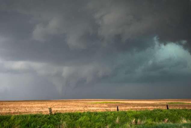
May 23, 2008
Chase Acct: May 22 (Northwest OK/Southwest KS)
This is a brief initial account. Will write a more detailed account on ths post later. I left work at 3pm and decided to chase the dryline instead of the warm front because a) storm motion would be a bit slower and b) I didn’t want to be a part of the zoo of chasers that were targetting the I-70 corridor. I did not see a tornado yesterday, but I’m not really disappointed with the chase. I observed a very nice but small supercell from southwest of May to Buffalo, OK to near Coldwater, KS. I observed large hail at to different locations 1) 1.25" diameter hail about 4 miles ENE of Buffalo and 2) up to 2.5" [tennis ball size] hail 8 miles east of Coldwater. The storm took on excellent rotation as it crossed the OK-KS border in approach toward the Coldwater area, but the overall size of the storm and dewpoints only in the 62-63F range really prevented a significant chance at a tornado. Nevertheless, the storm cycled through numerous classic RFD occlusions, etc. It was very photogenic toward the mid-evening hours.


May 9, 2008
Chase Acct: May 8, 2008 (Southwest KS)
Another day another chase close to home! These are much easier on the wallet. My chase route on May 8th was very similar to that of May 6th — starting out northwest of Garden City and following the supercell east-southeast through northern Finney County into western Hodgeman county. In fact, in Hodgeman county, I traveled some of the same dirt roads I did just two days prior — and had a similar "deja vu" experience of racing a storm back to Jetmore…and effectively ending the chase *in* Jetmore.
I had not planned in advance to chase May 8th, which was Thursday, in between my 1st and 2nd 9pm to 5am shifts. Only very rarely will I be able to chase on a day where I have to be in the office by 9pm. Typically, for this to happen, a storm has to form about an hour to an hour and a half west of Dodge City, and I basically chase it back east towards the direction of home. I also need to find out if the office is going to need me in early in case they were short-staffed for working severe. All the ducks were in a row for me to chase before work, so I set out for the Garden City area. Just after I left Dodge around 2:40pm, landspout tornadoes were already occurring in the Selkirk, KS area to the southwest of Leoti. A 1000 J/kg CAPE axis was positioned across the Garden City area to go along with very strong cyclogenesis just west southwest of Garden City. The low level and deep layer shear was excellent for supercells.
A formidable cell finally established itself south of Leoti which was heading for southern Scott County. I made my way to to Friend where I headed west then north on county roads for the intercept. The storm was a dry-classic supercell by this point with a fairly nice wall cloud. I opted to go north a bit to stay out of the sun, and viewed the updraft region from the northeast (instead of the traditional southeast). Contrast was excellent here, and I was able to get away with this due to the lack of precipitation with the storm at that point. Eventually, the new mesocyclone was taking shape along Hwy 83 and I had to get east… but beforehand, I optioned south to get back to the proper positioning south of the main updraft.
I reached the Finney-Scott county line road and continued east on this road for quite a distance, as the main updraft and mesocyclone rotation was about 6 miles north of me moving almost due east at the time. Cloud base rotation was becoming a little more prominent, but rather broad. Inbound winds on radar were approaching 70 knots (ground relative), so I knew this was a necessary ingredient for a future tornado. You could see this inflow visually at cloud base upstream… it was impressive east to west motion. Time at this point is about 5:10pm when I was positioned a few miles east of the Finney-Scott-Lane county tri-border. By 5:15 to 5:20 or so, precipitation was falling in the rear-flank downdraft region, and a huge pendant echo on radar was becoming well-established. I was running GR2Analyst and looking at higher slices, the bounded weak echo region (BWER) was incredible — one of the most prominent BWERs I have seen — and I’ve seen a lot of them. This was just a classic supercell in all aspects.
The RFD precip was approaching the county-line road, and it was fortunate that Hwy 23 came when it did. I did stop a few times prior to continuing south on a couple of one-mile legs. The first time I stopped at a T intersection with Mennonite Rd, I was observing some wild rotation in two different area to my immediate northwest and again to my more distant north. I was preparing to see tornado-genesis at this point. Time at this point was around 5:30 or so. The 2nd time I stopped at a 1 mile south leg prior to reaching Hwy 23, the RFD precip was bearing down on my location as a number of chase vehicles rounded the corner to go south. I got some decent images of the chase vehicles with the RFD precip in the background.
I finally made it to Hwy 23 where I blasted south…but the hook echo precip beat me. I was blasted by roughly 60mph west winds and large rain drops on the way to my next east option, which was Lake Rd. through Ravanna (which isn’t a town, all Ravanna is is ruins of one building). I had to keep blasting east to get a decent view of the new mesocyclone area. All this while, I was probably thinking there was a rain-wrapped tornado way back in the old occlusion. I never saw any evidence of such, though. At one point though, I did see what looked like a large old "tornado cyclone" cloud mass reaching the surface. That was interesting! It faded quickly though, and I only got photos of the break-up of this feature. As I made it into western Hodgeman county, the storm was transitioning fairly quickly into an HP storm as it was making its bead on Jetmore. I traveled east on a farm road a couple miles north of Hwy 156 on my way to Jetmore. The structure was quite good, despite the storm being very wet now just to my north. I eventually made it to Hwy 156 and then to Jetmore before the large hail hit…and I continued south on my way home. I ran into my co-worker, Scott, who was out chasing with his son south of Jetmore as we watched the now HP supercell travel east away from us. New storms were forming to the northwest, and I managed to get a few images of this before finally calling it a chase. When I finally called it a chase shortly after 7:30pm, I was only about 10 miles from home — still having almost an hour time to spare before going into work! A very nice "spontaneous" chase to say the least!


May 7, 2008
Chase Acct: May 6, 2008 (Southwest KS)
My chase target on Tuesday, May 6th was west-central Kansas somewhere with a starting point of Scott City in mind. I set off for Scott City around midday, reaching the Scott City area around 2:30pm. There were already storms developing between Lamar and Holly where convective temperature was being reached in the 83-85F range. A cluster of small storms had eventually evolved as they moved into the Syracuse, KS area. This activity was moving into 2500-3000 J/kg surface-based CAPE environment with dewpoints around 58-59F or so. I expected an organized severe storm to form out of this stuff.
After monitoring things for a while just outside of Scott City, I drove south to intercept the primary strong updraft north of Highway 50 between Syracuse and Lakin. I eventually reached a stopping point about 5 miles north of Holcomb where I got a pretty good view of the high-based updraft at around 4:00pm. The storm rapidly strengthened by this time and took on supercell characteristics. Inflow was excellent into the storm with south-southeast winds around 25-30 mph. A high-based wall cloud showed periods of interesting rotation to my northwest, and as long as the rear flank downdraft wasn’t cold enough, tornadogenesis would be possible. Of course, that wasn’t to be. Around 4:15pm, I started to get nailed by cooler west winds denoting the more stable rear-flank downdraft. Once I felt this, I knew tornado prospects were done. I drove east a few miles before noticing a number of dusty spin-ups (RFD gustnadoes) at the inflow-rear flank downdraft interface. I was fairly close to a couple of them and got a few photos. It was time to keep heading east and focus on the structure of the storm.
Around 5:00pm, the storm developed another classic RFD clear-slot, albeit still high-based. Around this time, looking to the north-northwest, the rotation in the wall cloud was probably about as good as it ever got with this storm, and a nascent funnel (albeit quite brief!) developed beneath this rotation. This feature quickly fell apart, and I continued east along Hwy 156. By 5:30, several other storms were developing immediately northeast of the initial supercell…all spewing out cold outflow as well…so it wasn’t long before this whole system was severely outflow dominant. Around 5:45, I manged to stay far enough east to get one decent set of images of the original supercell updraft with a long high-based shelf cloud extending northeast. I wallowed about western Hodgeman county through 7pm photographing the storms along and north of Hwy 156. Another strong updraft surge developed northwest of Jetmore around 7pm or so which revealed interesting structure, of course about 10-12 miles north of the outflow boundary.
I drove back to Dodge, but instead of heading home, I continued west to Cimarron then north a few miles to photograph some lightning at the west end of this complex. Not much success with the lightning, but managed to get a couple images. I was back home by 9:15pm or so.


May 6, 2008
Chase Forecast May 6, 2008
Likely targeting western KS
Today is my day off, so I plan to chase. I have really been waffling between two areas of interest: The more consensus TX Panhandle choice or western KS. I think I am going to target western KS. The reason I like the looks of DDC-GLD CWA border region of western KS is 1) a band of increased 250-300mb flow in this area around 70-80kts (despite the more anemic ~500mb winds of 30-40 knots or so)… and 2) the roughly 0-2km lower tropospheric convergence looks pretty darn good late this afternoon/early evening across western/northwestern KS — a lot better than what I’m seeing progged across the TX Panhandle. The NAM has shown a very persistent "convective QPF bomb" signal at the nose of the 850mb speed max that sets up from, say, Tribune northeastward to Wakeeney…then continuing northeast to Stockton-Osborne by the 03-06z time frame. Dewpoints in the 60-62F territory may be realized up in this target as convergence increases later on. And lastly 3) it’s the "secondary" target as all the "hordes" will be in West TX. Will continue to monitor. I can sit here until Noon in-case TX PH starts calling my name again.. but as it stands now, I think I’ll be heading NW or WNW from DDC instead of SW.
April 27, 2008
Chase Acct: April 26, 2008 (West Texas)
April 26th was a very productive storm photography day. Lightning was nothing short of spectacular with a supercell thunderstorm that moved slowly across the San Angelo area. On the way north to Abilene late in the evening, another storm produced spectacular lightning.
I intercepted and photographed the San Angelo high-based supercell. AsI was en route to the San Angelo area from Big Springs, I ran into BillReid as the storm was in its incipient stage. The storm underwent a classic split after initiation to the south of Sterling City.Eventually, the right split finally took over, and I followed the storm southeast on approach to San Angelo. I decided to take Ranch 2288south, to bypass the city. This was a good choice as it offered me a wonderful view of the storm without the nuisance of dealing with the city. I connected the Lightning Trigger to my Nikon D200 after it became apparent that photogenic CG lightning was occurring at a reasonable interval around the updraft. It worked like a champ. The success rate with the Lightning Trigger is about 20-40% or so, I am finding, when shooting at a 1/10 to 1/30 shutter speed, depending on the on the return strokes after initial flash that triggers the device.There was so much lightning with this storm — high-quality, brilliant lightning. I cannot recall a storm of recent memory that I had so much fun photographing with respect to lightning. The supercell really became outflow dominant as it came into San Angelo. Overall supercell structure was pretty good, but the CG lightning was what made this storm a real treat to the photographer. East of San Angelo, I was leap-frogging Bill Reid and Paul Sirvatka’s COD team, staying ahead of the storm on Hwy 87 to Eden. I was able to capture a fantastic image looking west down Hwy 87 of a spectacular CG with COD’s chase vans in the distance on a hill.
I went south on Hwy 83 about 10 or 12 miles to photograph a little more…which was when I lost internet connection. There’s a data hole in this area. The SCIT track had the storm crossing Hwy 83 about 7miles south of Eden, so I waited patiently until the core of the storm crossed in front of me to the north. I went back north to Eden after about 20 minutes to find a wintry scene of hail covering Hwy 83 several inches deep over a couple mile stretch. From the last radar image I saw before data loss, there was another small supercell taking bead on the Ballinger area in time. I was planning to head to Abilene anyway, so I was hoping for a little more lightning. I was pretty greedy at this point — having an awesome good time! I stopped a couple times around the Paint Rock area for more incredible lightning. It was a staccato-fest! Bill Reid said it best after I saw him the final time when we were west of Eden: "It was like taking candy from a baby". What an incredibly fun chase. Below are a few crudely processed images that I did on my laptop. I have a couple more on my blog:
Below are a few of the best images of the bunch from yesterday’s chase:


April 26, 2008
Chase Forecast: April 26th – West Texas [post 2]
Sitting in Childress at this time about to take off for Lubbock area where I’lllikely spend much of the afternoon. RUC and NAM suggest near 2000 J/kgto develop in the northward advecting moist axis through West TX. Del Rio morning sounding shows pretty good moisture which is already advectingnorthwest just off the surface. Midland sounding had highest mixing ratiojust above ground level with near 50F. I think by 00 UTC, there shouldbe widespread upper 50s to near 60 dewpoints from Midland to Lamesa toSnyder…perhaps as far north as Lubbock. I think the best play is right atthe nose of the good low level juice… so my initial target isLamesa-Post-Snyder area for initial 22-00 UTC development…thentowards Jayton-Rotan-Aspermont area later in the evening.
April 25, 2008
Chase Forecast: April 26th – West Texas
I will be driving to Childress, TX after work this afternoon to set up for a Saturday chase in West Texas. Low level moisture will return back north tomorrow across West Texas with dewpoints reaching upper 50s to near 60 as far north as northwest Texas. Another shortwave disturbance will dive southeast out of the Rockies tomorrow putting West Texas in substantial forcing for ascent and subsequent deep, moist convective development. Surface-based CAPE values may reach 2000 J/kg by late afternoon. At this point, I’ve got my eye on an area between Lubbock and Childress, but may travel as far south as I-20 to Abilene. The key tomorrow is to a) be close the advancing low level moisture and b) remain well south of the charging cold front. I think both should be accomplished with relative ease.
Chase Acct: April 24, 2008 (Northwest KS)
I was able to leave work right at 4pm for yesterday’s chase. As Iposted in the FCST thread, the area I was most interested in was alongand north of US-24 to Nebraska. I met up with Tony Laubach and VerneCarlson for a short time east of Ness City as some cumulus weresomewhat intriguing at the nose of a small scale mixed-out warm plumewhere convergence was locally maximized. I told myself that if the Cudidn’t look any better in 45 minutes, I would bolt northwest where Iwas extremely confident there would be a sustained surface based severestorm where the deep tropospheric forcing was much better acrossNorthwest KS. The first storms were developing with some decent echoesaloft around Goodland, and at that point, I continued north toWakeeney, then northwest to Hoxie, to my first stopping point south ofRexford. The southern storm had some nice shape to it and appeared tobe supercellular, but it was small. Of interest at the time was alarger mass of convective updraft due north. These two storms mergednorthwest of Rexford, and the storm really took off. Of course, it wasgetting well into the evening by this point, but the supercellstructure was quite fine…although high based. The westernmost portionof the storm revealed an interesting lowered feature, which I guess youcould call a wall cloud, but there was a lot of outflow dust beneath itlooking roughly west from near Hwy 23-83 junction at Seldon. It was toodark for handheld photography, so I tried my best to get the tripodsetup for some 1-3 second wide angle exposures amidst strong eastinflow winds and blowing dust.
Now,idiot me, I continued east on Hwy 9, instead of joining the massesheading south on 23. I guess I was expecting the storm to move more dueeast…and from my perspective due east of the storm, the structure waspretty good from a photography standpoint. I stopped briefly about 6 WNew Almelo for more long-exposure photography on the tripod before Ibegan to get pelted by quarter-size hail. Looking to thewest-southwest, the supercell structure looked pretty darn good fromthis vantage point on Highway 9, so the decision to head east insteadof south I guess wasn’t so bad after all. Of course, by the time I gotfar enough east to reach a south option again at Hwy 283, it was dark,and there was little if any decent lightning illuminated structure. Ireached Hill City amidst blaring tornado sirens, continuing southhopefully far enough south to get out of the cloud canopy so I can geta nice distant view of supercell structure. It really wasn’t to be. Idid stop at a high spot south of Hill City where other spotters andchasers also stopped, but by this time, the supercell circulation waseast of Hill City. There were a lot of lightning illuminated "hangydownies" just west of where the radar had strongest rotation near HillCity. There was nothing more to shoot of interest photography wise, soI headed south towards Wakeeney in hopes that maybe a very distant viewof the storm could be interesting, but even that wasn’t all that wascracked up to be, so I continued to Wakeeney, ate dinner, and headedhome. A fun little chase. Below are a few images (all 12mm wide angle):


