High Plains Drifter


disclaimer:  "The meteorological views/forecast thinking expressed are those solely of the author of this blog
and do not necessarily represent those of official National Weather Service forecast products,
therefore read and enjoy at your own risk and edification!"

June 20, 2010

Chase Trip Day Three (June 19) Summary

Written by my chase partner Evan Bookbinder:

Day 3 of the chase trip (June 19th) played out pretty much as we expected this morning, targeting north central Kansas once again (High Plains Magic will have to wait one more day). After checking out a few storms along highway 24 (including ping pong ball hail near our favorite town of Osborne), we got on an HP supercell just north of Beloit. This storm served up some amazing structure, including one of the most aqua green skies I’ve ever seen, and filled with cloud to ground lightning. It made several attempts at wrapping up, but after clearly becoming outflow dominant we dropped south for some distant shelf/structure shots before letting the bow echo overtake us. Additional upstream elevated storms provided a great lightning show well into the evening, but the flooding is getting quite bad across this region back toward Concordia. We are headed toward York and I-80, ready to bust west for tomorrow’s show.

Start:  Denver (Westminster), CO
End:  York, NE
Day 3 mileage: 648 mi
trip mileage: 1453 mi

Images from Day 3′s chase:

20100619_191306

20100619_194300

20100619_194712

20100619_195952

20100619_200619

20100619_222850

June 18, 2010

Chase Trip Day One (2010 June 17) Summary

Filed under: Late Chase Trip 2010,Latest Chases,Storm Chasing — Mike U @ 11:02 am

Supercell,  mammatus, lightning, colored sky, and heat burst — North-central Kansas near Osborne

Evan Bookbinder and I had a fun evening of storm photography across northern Kansas along the Highway 281 corridor around the Osborne, KS area.  At 10:00pm, we experienced an awesome heat burst which rose the temperature to 95 degrees with a 45 degree dewpoint.  Winds were out of the south gusting to around 50 mph at times.  Below are a few photos from this storm chase shoot.

Begin:  Lee’s Summit, MO
End:  Hays, KS
Day One miles: 435
Trip miles:  435

20100617_191610

20100617_203619

20100617_210208

20100617_210152

20100617_215756

June 14, 2010

Chase Account 31 May 2010 Pritchett-Campo, CO [Part 2 of 3]

Filed under: Chase Accounts,Latest Chases,Storm Chasing — Mike U @ 7:58 pm
The long-lived, significant tornadic supercell of 31 May 2010 will go down as probably my most thoroughly and successfully documented significant tornadic supercell in my 13 years of storm chasing.  There were three distinct phases of this storm chase, and as such, I will document this account and share my images in 3 parts.  The first phase (Part 1 of 3) was the time frame from roughly 2:45pm to 4:30pm which included a 20-minute tornado southwest of Pritchett, Colorado.  The second phase was a long period from 4:30pm to about 7:00pm when the supercell was non-tornadic but still cycled through several significant occlusions, one of which was very close to being tornadic (Part 2 of 3).  Lastly, the Campo, Colorado significant tornado, the hallmark moment of this supercell, will be documented in Part 3 along with the post-tornado sunset structure as the storm rolled southeast into the Oklahoma Panhandle northeast of Boise City.

Part 2 of 3. 4:30 to 6:55pm CDT (Non-tornadic phase)

(times CDT unless otherwise noted.  numbers in brackets refer to the image number in the embedded image album at the end of this post)

After the south of Pritchett tornado dissipated, the supercell entered a non-tornadic phase, which lasted from roughly 4:30pm until about 7:00pm.  After photographing the tornado, I drove east about a mile and a half then south two miles photographing the storm structure at various points along the way through 4:50pm.  The storm appeared to be taking on a high-precipitation supercell structure with a large mass of precipitation descending from near the main updraft area looking off to the west [1,2,3,4].  I was expecting the storm to approach my location… but it simply wasn’t doing so.  It was moving straight south.  So instead of just sitting there waiting for the storm to approach, I decided to head west again and then drift south.  I sat for awhile at a county road intersection as lightning activity was increasing abruptly.  I set up the tripod with the D200 in hopes of capturing a cloud-to-ground (CG) flash with the storm structure to my west northwest.  I didn’t capture any CG’s, so then I went south.  There is one county road that goes into the far western Oklahoma Panhandle to Black Mesa Park, and I was seriously considering taking this road considering the storm motion straight south… so I made my way south and west through 5:15pm, stopping along County Road 13 about 5 miles north of the Oklahoma border.

I photographed some of the high-based storm structure from here [5] and then drifted back to the north to the road intersection with County Road G where I met up with a group of Canadian storm chasers.  We sat here at this road intersection for a good 10 to 15 minutes or so [6,7,8].  It was at this time that the storm appeared to be making more of a southeast track instead of the due south track it had been taking.  The decision now was to head east back to highway 287 at Campo.  I was in no hurry, though, since the storm was still just crawling at around 5 mph.  At around 5:45 to 5:50pm or so, a high-based rear-flank downdraft clear slot was developing to the north [9].  I drove about three miles east or so and stopped to photograph a new wall cloud to my north-northwest.  This wall cloud in the RFD occlusion was classic [10], and I was preparing for another tornado, setting the tripod up with my D200 zoomed in to about 70mm for some up-close images [11,12].  Right at about 6:00pm, a laminar funnel developed within the tightening wall cloud [14,15,16], making up the tornado cyclone scale rotation.

It came very close to producing a tornado here, and it is quite possible there could have been unseen ground-based rotation beneath the laminar funnel.  I could never confirm a tornado, nor did any other chaser that I know of.  About three or four minutes later, this laminar funnel became a little more stretched out and diagonally oriented [19] as it began to dissipate.  The whole wall cloud area then became wrapped up in rain around 6:10pm [20,21], and I continued east toward Campo.  There were quite a few people from town, including local spotters, watching the storm from the west edge of town on County Road J.

At 6:20pm, I reached Hwy 287/385 and headed south from Campo about 3 miles before stopping along another county road adjacent the highway.  I met up with the College of Dupage group at this location and photographed the structure with some wildflowers to the northwest [23,24,25].  I photographed from this location for about 10 or so minutes before continuing on.  At this point, I was quite content with the chase and decided not to get too cocky in positioning.  It was all about finding the right light at this point since the sun was getting lower.  I didn’t want to shoot into the light to the west.  I took a county road (County Road C) east about a mile or so and found a high spot to shoot from.  There was a fairly well-developed high-based “swirl” marking the new mesocyclone to my northwest [26,27,28].  I sat here for about 10 minutes as well watching this feature approach.  Time was about 6:45 to 6:55pm or so.

With the light pretty harsh to the west, I got tired of shooting to the northwest, so I went back west to Highway 287/385 then south about 1/2 of a mile or so before stopping again along the shoulder of the highway.  Again, up to this point, the chase day was going perfectly, and I was very content with what I have seen up to this point.  Little did I know what I was about to photograph from this very location.  Details of this… the so-called “Campo Tornado”… in Part 3!

This SimpleViewer gallery requires Macromedia Flash. Please open this post in your browser or get Macromedia Flash here.
This is a WPSimpleViewerGallery

June 9, 2010

Chase Account 31 May 2010 Pritchett-Campo, CO [Part 1 of 3]

Filed under: Chase Accounts,Latest Chases,Storm Chasing — Mike U @ 1:25 pm
The long-lived, significant tornadic supercell of 31 May 2010 will go down as probably my most throroughly and successfully documented significant tornadic supercell in my 13 years of storm chasing.  There were three distinct phases of this storm chase, and as such, I will document this account and share my images in 3 parts.  The first phase (Part 1 of 3) was the time frame from roughly 2:45pm to 4:30pm which included a 20-minute tornado southwest of Pritchett, Colorado.  The second phase was a long period from 4:30pm to about 7:00pm when the supercell was non-tornadic but still cycled through several significant occlusions, one of which was very close to being tornadic (Part 2 of 3).  Lastly, the Campo, Colorado significant tornado, the hallmark moment of this supercell, will be documented in Part 3 along with the post-tornado sunset structure as the storm rolled southeast into the Oklahoma Panhandle northeast of Boise City.

Part 1 of 3. 2:30 to 4:30pm CDT (Pritchett, Colorado tornado)


(times CDT unless otherwise noted.  numbers in brackets refer to the image number in the embedded image album at the end of this post)

I left Dodge City shortly after 11:00am and decided to head toward Springfield, Colorado.  I deliberated for quite awhile… even up until I had to make the turn west of Dodge City… whether to fully commit to the far southeast Colorado target or to head to Lamar first before re-evaluating.  I ultimately decided to take the new South Bypass to get on Hwy 56 and eventually 160 (instead of staying on Hwy 50 to go to Lamar).  Looking at the visible image and seeing the low stratus across southwest Kansas, eastern Oklahoma, and the eastern Texas Panhandle… with clearing to the west — while there was an absence of thin morning stratus farther north — was a clue to stay south (better, deeper moisture).  This was the good kind of morning stratus — the thin stuff the burns off fairly easily by mid-day.  Thin, broken stratus on the western plains is a good sign for late day severe weather when there are southeast surface winds and westerly flow aloft… in late May.

Before I even reached Ulysses, KS, towering cumulus was developing in the target area of far eastern Las Animas County between Kim and Pritchett.  Instead of taking a leisurely stop and eating lunch, I just grabbed some fast-food and continued on my merry way west to Springfield.  I reached Springfield around 1:45pm with a small storm to my west near Pritchett.  The initial storms would develop and dissipate only to reform in the same spot.  After a quick pit stop in Springfield, I continued west on Hwy 160 to Pritchett.  My first stopping point was a couple miles northwest of town on an unpaved county road, where I sat there and watched the genesis of the soon-to-be supercell [1].  I sat there from roughly 2:15 to 2:45pm watching the storm updraft mature to my west a few miles.

Shortly before 3:00pm, I observed the first of two distinct funnel clouds with the initial mesocyclone occlusion looking west from about 4 miles west of Pritchett [2]:

  • “persistent well developed funnel cloud about 1/3 to surface from cloud base.  too far away to tell if it was a tornado or not, but it was in the cyclonic shear side of the RFD occlusion… it just dissipated at 1:55pm mdt… lasted a couple minutes”

After that SpotterNetwork report, I drifted south and observed the next funnel cloud [3], with its condensation funnel reaching a bit closer to the surface than its predecessor:

  • “another funnel cloud at 2:02pm mountain looking west-northwest from my position… 1/2 way to surface possibly a tornado cannot see debris cloud”

A secondary cell was developing immediately south of the original updraft which was producing the funnel clouds..and its rain core was beginning to come over me while on the unpaved road.  I made it a point not to go very far off of Hwy 160 just in case it started raining… also making sure that the unpaved road I was on was a hard-surface, well-graded road…which it was… so I made my way east a couple miles to Hwy 160 where I continued south.  The time between 3:15 and 3:30pm or so was when the storm was really beginning to blossom with that southern cell now merging with the former cell and essentially taking over.

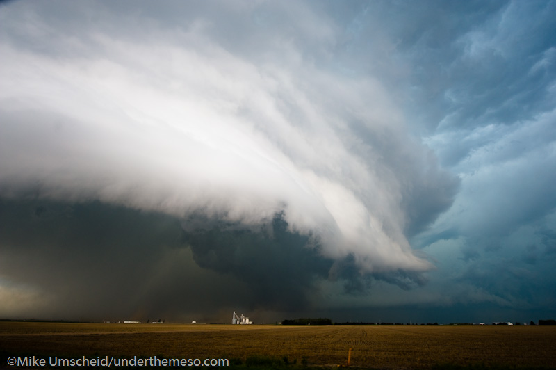
After a brief bout of nickel size hail and rain, I re-emerged into the inflow sector and was greeted to a nice broadly rotating cloud base lowering to my west.  I noticed Roger Hill’s tour group at the corner on 160 south of Pritchett, and I set up shop probably 1/4 of a mile south of him.  I sat there from 3:30 to 3:45pm or so before continuing south.  In that time, I photographed the storm structure [4,5,6] with, at times, well-developed rotating wall cloud to my west northwest.  Inflow at my back facing the wall cloud was sustained 30-40 mph at times from the east-southeast.  I had to stand in front of my tripod just to make sure it wouldn’t fall over in the inflow.

I drove south a couple miles to County Road U where I then continued east about one mile in order to get a better view of the overall structure of the supercell.  The area of rotation to my northwest a few miles was becoming a little more consolidated [7,8,9] with some semi-transparent precipitation falling in the RFD area of the supercell to the southwest of the wall cloud.  At around 3:58pm, a nice laminar funnel developed [10] from the wall cloud which hovered around a third of the way to the ground.  In a matter of a minute or two, this funnel was likely making ground contact, although I could not confirm this for sure, but the motion in the funnel cloud, the well-established tip of the condensation funnel and the overall organization of the clear slot… all were a pretty good clue that this was likely a tornado.  It was also persistent.  [11,12]

  • “looking northwest, fairly stout well developed condensation funnel over 1/2 to the surface from my perspective about 5 S Pritchett”

At 4:03pm, the tip of the condensation funnel reach over halfway to the surface from cloud base [13]…and by 4:04pm, a fairly large triangular-shaped condensation funnel was established.  I photographed both wide-angle (14 to 18mm on the full frame D3) [14,15] to capture the entire structure with the tornado as well as zoomed-in 50 to 70mm on the DX sensor (Nikon D200) to focus on the tornado itself.  Finally, condensation whisps were visible beneath the bowl-shaped condesation funnel at around 4:05pm [16].  At 4:07pm, the tornado was a large bowl-shaped funnel cloud with a small tip condensation funnel with numerous condensation and/or dust whisps looking to the northwest [17].  This then evolved into a more classic truncated cone shape [18,19] with condensation filaments at the tip of the funnel with a small debris cloud beneath at around 4:08pm.  The rear-flank downdraft/occlusion was classic from the southeast vantage point…with a hint of aquamarine color around the occluding tornado cyclone at cloud base [20,21,22].


I called the Pueblo NWS office to give them an update on my observation.  Right as I was making this call, looking off to the west was another very impressive funnel cloud/likely tornado (given the size/laminar shape of the funnel) [25,26].  This was probably 3 or so miles south of the main tornado looking to my northwest.  I believe this was an anticyclonic tornado given its position on the anticyclonic shear side of the rear-flank downdraft.  Shortly after I hung up, I posted another SpotterNetwork report:

  • “two tornadoes.  main tornado looking northwest about a mile or two… and another slender tornado to my west.. photographed both in one frame.  main tornado has been periodically on the ground for a number of minutes… perhaps up to 10… it’s a cigar-shaped funnel now with debris whisps observed at times.”

At 4:10pm, the main tornado to the northwest was a vertical cigar-shaped funnel with continued periodic suction spot spin-ups at ground level [29].  I was easily able to capture both tornadoes in one frame with my 14-24mm lens on the D3 [27,28].  The anticyclonic funnel/tornado lasted until about 4:12pm before it finally dissipated.  Meanwhile, the main tornado was still in progress to my northwest.  The entire storm was moving at a snail’s pace, and I was still sitting at the same location as I was 15 minutes prior watching and photographing this entire event unfold.  By 4:15pm, the entire condensation funnel was beginning to shrink and stretch more.  Briefly, the condensation funnel reached all the way to the surface at 4:15pm [31,32,33].  The tornado finally dissipated about a minute or so after that — for a total of just under 20 minutes for this tornado.  After this tornado dissipated, it was time to reposition.

Part 2 of 3 will document the non-tornadic phase of this incredible supercell storm between 4:30pm and 7:00pm — the moments before the Campo tornado.

This SimpleViewer gallery requires Macromedia Flash. Please open this post in your browser or get Macromedia Flash here.
This is a WPSimpleViewerGallery

June 7, 2010

2010 June 6 Northeast Colorado chase

Filed under: Chase Accounts,Latest Chases,Storm Chasing — Mike U @ 8:45 am

Marginal supercell storms, high-based, across northeast Colorado.  Taken with point and shoot camera since I didn’t have my Nikon DSLR gear with me as I was coming home from a bowling trip in Reno.

20100606_173240

20100606_180358

20100606_192900

20100606_194648

May 25, 2010

May 22, 2010 South Dakota Tornado-fest [post 1]

Filed under: 2010 May 22,Latest Chases,Storm Chasing — Mike U @ 9:21 am

Preliminary Images:

May 17, 2010

Chase Summary: May 10, 2010 (West-central Kansas)

Filed under: Chase Accounts,Latest Chases,Storm Chasing — Mike U @ 11:46 pm

Fast-moving HP Supercell at Shallow Water, Kansas


May 10th was the much advertised and much hyped (for good reason) tornado outbreak across the plains from southern Kansas into Oklahoma.  Since I was still on my 10pm to 6am shifts, I was on a tight leash, so I couldn’t venture far from Dodge City if I wanted to chase.  There was a target close to home with storms most likely developing by midday or shortly thereafter given the degree of forcing coming out with the compact upper low moving into southwest Kansas.  By late morning, there was an axis of instability developing across far west central and southwest kansas as the stratus was slowly eroding away at the western edge.  It was this corridor of instability where I focused my efforts on.  After about three hours of sleep, I woke up to find things on target for the most part.  My chase target was northwest of Garden City for the incipient storm development… and points northeast from there as the afternoon grew on.

I left Dodge City at 11am and headed north to Ness City then west toward Dighton.  By 12:30pm, convection was forming in the drier air between Lamar and Syracuse which was moving northeast toward the Hwy 50 corridor and the Syracuse area.  Radar was showing an east to west boundary developing and there appeared to be a convergence of fine lines on radar near the Garden City area.  I decided to drive south into northern Finney County and watch things unfold to my southwest.  As I got into clearing skies, the convective towers were obviously quite evident… including one to my distant south-southeast.  The cluster of disorganized showers and thunderstorms to the west-southwest were about to enter the higher moisture content around 1:00pm, but it was also cooler, which was a problem.  There just didn’t appear to be a whole lot of clearing farther to the east to widen the axis of instability for potential tornadogenesis.  By 1:30, storms finally increased in intensity west of Lakin, and this activity was moving northeast which would approach Hwy 83 between Garden City and Scott City, so I made my way west to Hwy 83.

When I reached Hwy 83, I was greeted to a massive updraft area to my southwest.  Tornado warnings were issued for storms farther north in the Leoti area.  It turned out that there was a small cluster of non-supercell, landspout tornadoes.  Oh well.  I drove north on Hwy 83 to Shallow Water when the storm to my southwest was wrapping up significantly.  This was turning into an HP beast, and I found myself in the notch of this thing.  I got out of the car to take a few images, but I couldn’t do that long, as this storm was racing northeast at 50 mph.

As I drove north through Shallow Water, the structure to my southwest was fairly impressive with a nice circular, striated updraft area with a low-contrast lowering wrapping in rain to my west-southwest.  Meanwhile, the wet RFD was racing north toward me fast.  I made it to Hwy 96, but about 4 to 6 miles east of Scott City, I was being buffetted by 60 mph south winds in the RFD.  This was really the beginning of the end of the excitement of this particular chase.  The storm quickly became an outflow dominant mess as I was continuing east toward Dighton.  I had some thoughts of just heading on home, but renewed updraft development on the old rear-flank gust front, which was now the leading edge of the synoptic dry intrusion, kept me just interested enough to continue following it.  I followed it to Utica and eventually Ransom in northern Ness County along Hwy 4. There was a new mesocyclone to my southwest…

…and shortly after 3:00pm or so, there was a report of a tornado with this circulation, however I never saw this.  Later on, I did see some photos of this feature, which was indeed a small, brief tornado.  Unless you were in the right spot, you would not have seen this (and I was not in the right spot plus I was driving while this was occurring apparently).  Storms moving 40 to 50 mph just do not give you the necessary amount of time to figure out what’s going on, especially when chasing solo.  Plus the fact, the cloud bases were so low because the storm was moving into the area of low stratus that had stuck around all day up until that point.  Not great conditions to photograph in.  The best photography would actually be behind the storms looking at them from the southwest in the drier air.  I entered Rush County and photographed some of the interesting convective underbelly of the storm in between the updraft area and the precipitation core.  This was somewhat photogenic, especially with a green wheat field in front of me.  This was around the 4:00pm time frame near McCracken.

I followed the storm as far east as the Hoisington-Russel longitude before giving up and heading back to Dodge City.  I didn’t see any tornado on this outbreak day, but it was an interesting chase nonetheless.

11 images from this day’s shoot:

This SimpleViewer gallery requires Macromedia Flash. Please open this post in your browser or get Macromedia Flash here.
This is a WPSimpleViewerGallery

May 3, 2010

Chase Trip Day Nine (May 2) Summary [13 images]

High-based storm & lightning near Grainfield, Kansas


(rest of images at the bottom of this post)

I was not expecting much on this day given dewpoint temperatures in the mid to upper 30s across much of western and central Kansas, however there were going to be storms based simply on the notion that temperatures in the mid levels…500 to 700mb… were still very cold.  500mb temperatures were going to be around -22 to -23C.  The problem was that there wasn’t much of a focus for initiation to zero in and target on for chasing.  Where was the best storm to photograph going to end up being?  The environment looked equal just about everywhere from southwest Kansas into south-central Nebraska.  I decided to use the RUC model as my guide as it was showing a corridor of southeast winds with a little bit better moisture… say mid 40s dewpoints… advecting back into west-central Kansas around Ness City perhaps.  As it turned out, these winds never really materialized, and winds were quite light everywhere.  The first storms developed farther north… north of Hill City, and this is where I was led.  I made it to Hill City and eventually Norton, going after some briefly strong storms just into Nebraska near Alma.  By the time I reached North I drove east to get into better position of these, but as I was doing this, those storms eventually waned with a bunch of other scattered weak convection developing to my southeast, south and southwest.  Where to now?  There was no need to be this far northeast when I could be a bit closer to home to photograph essentially the same convection.  So I headed back southwest.  I followed Hwy 9 west-southwest to Hwy 23 north of Hoxie as this areas was convecting better than any other, so I thought what the heck, I’ll just get closer to this stuff.  I went south to Hoxie and eventually Grainfield when the “storm of the day” for me came into view to my southwest.

I wanted to get into a decent position for this cell, so I drove south on an unpaved county road southwest of Grainfield.  I stumbled upon my shooting location of choice.  A farm field with old corn stalks and an old barn making for a fantastic foreground subject.  I used this old barn to my advantage — it certainly made the shoot!  I set the D200 up with the lightning trigger and let ‘er go to work while I roamed around with the D3 to get some compositions of this old barn and the storm.  I managed to get a few cloud-to-ground images from this storm with the barn off to the right.  I think these compositions with the storm, lightning, and old barn work best as 2:1 crops in post-processing, which is what you’ll see in the album of images from this shoot.  One of the frames even has me in the shot, which actually kinda works in a way for perspective!  I felt pretty satisified with this and decided not to get greedy and begin my way back home.  I went south on Hwy 23 to Gove only to find that it was closed south of Gove.  I was forced to turn around and head back to I-70, but the next storm that developed in the cluster was producing some decent lightning frequency, so I gave it one more attempt to photograph just northeast of Grainfield this time along Hwy 23.  I was at this location for probably 15 or 20 minutes before the lightning activity waned.  At that time I decided to finally head on back to Dodge.  This was exactly the kind of shoot I was hoping for, but honestly wasn’t expecting.  I think one or two of the images from this day are Portfolio-worthy.

Begin:  Dodge City, KS (home)
End: Dodge City, KS (home)
Day Nine Mileage: 431 mi.
Trip Mileage: 4085 mi.

13 images from this day’s shoot:

This SimpleViewer gallery requires Macromedia Flash. Please open this post in your browser or get Macromedia Flash here.
This is a WPSimpleViewerGallery

May 1, 2010

Chase Trip Day Six (Apr 29) Summary [20 images]

A dryline bust saved by late storm initiation on the cold front at Wilson Lake, KS.

(rest of images at the bottom of this post)

My target all along was the dryline just south of the cold front — somewhere from Great Bend to Pratt.  I didn’t waver from this target, except briefly right after I had lunch in Hays when cumulus was already forming from west of Salina to east of Hoisington.  I drove south from Hays after lunch, which pretty much sealed my fate for chasing the northern storms that 97% of the other chasers were chasing.  Once I reached La Crosse, KS, I turned east to Hoisington watching the southernmost cumulus congestus to my east-northeast.  Briefly, I thought this would be the intercept.  I then noticed more aggressive cumulus growth to my south in my original target, so that was the clincher for me.  I blew off that congestus to my east-northeast and dropped south from Hoisington.  1km visible satellite also confirmed this nicely with a clumping cumulus field centered across Stafford County and points south-southwest of there to between Greensburg and Pratt (4:30pm).

I made it down to Stafford which was where I decided to stage between 4:45 and 5:15pm.  Nothing was happening with my cumulus field to the west through southwest… and I was becoming increasingly anxious.  The best convergence on the dryline appeared to be shifting north a bit, so I moved back north and sat again along a farm road from about 5:30 to about 6:30.  I spent most of this hour interrogating the models for the next couple of days of my vacation.  Still nothing to my west through southwest.  In fact, what cumulus was developing was quickly turning into a big area of virga.  This wasn’t good!

The NAM and GFS models were insistent in vigorous convective development in the 00z (7pm) to 03z (10pm) time frame… right around sunset, with the southern edge of this vigorous development right about Great Bend.  I felt very confident storms would eventually develop, but along the cold front instead.  The cold front was slowly moving south toward the best dryline convergence.  It was just a matter of time before initiation.  In the meantime, I trudged north on farm roads (7:30pm), watching this huge area of virga shower activity from my northwest through southwest.  You could make out some bases in spots, but nothing that said “come chase me” yet.  It was just about to go.  So I continued my merry way north (8:00).

Once I reached I-70 at around 8:30pm or so, the atmosphere finally let loose:

Intense development along the cold front all the way down to southwest of Great Bend!  There were embedded mesos in spots along this line of convection, and the one I concentrated on was just west of Wilson Lake.  There was a good view from Wilson Lake, so I decided to stop here and begin shooting.  I was greeted to some insane inflow winds from the southeast!  I estimated winds in the 50-60mph range… which was difficult to stand in, let alone to try and photograph in… or even set the tripod up (after all it was now 8:45 by this time and light was low!).  Electrical activity was pretty good in the updrafts, and I managed to capture this to some degree in the stills.  Since the activity was moving northeast instead of straight east, it allowed me to drive east and stay ahead of the storms… stopping for about 5-10 minutes to shoot, and then repeat.  I continued east from Lincoln to Beverly.  The best storm on the line now appeared to be to my southwest, so I headed south on an unpaved farm road from Beverly at around 9:45pm.  This turned out to be a fateful move.

I blew out my front driver’s side tire.  On a dirt road.  With a storm to my west about a half hour away (10:05pm).  I could still drive on the flat, but no faster than 20 mph.  It was imperative I find pavement, and thankfully I was only 3 or 4 miles from an I-70 interchange west of Salina.  I limped south and by a stroke of luck, one of the next east-west county roads was paved!  I stopped here.  Since this was a new Jeep that I had not changed a tire on before, I had to learn the little idiosyncrasies for spare tire changing with this vehicle on the fly… with a storm headed my way.  I didn’t think I had any time before the storm hit, so I resorted to just photographing the damn storm updraft, since it was fairly photogenic…

The cell to my immediate west would miss me to the north, and I just got a few big rain drops (10:30pm) and it ended shortly thereafter.  I had a brief window of opportunity to get the spare tire on before the next cell hit.  That window was about 15 minutes…

…It took me longer than that to complete the job, because I started to get poured on shortly before 11:00pm.  So now it was a waiting game… with my vehicle jacked up.  So now I’m sitting in my Jeep with west winds gusting to about 60 mph rocking the Jeep a little bit while it was jacked up.  I felt pretty confident that despite these winds, the jack would hold.  And it did.  So now I know I can have the vehicle jacked up in 60 mph winds, LOL.  Not again, though.  Next time, I will have it calculated down IN ADVANCE how long it takes me to change a tire.  As much storm chasing as I do, this is the #1 reason for a break-down.  A flat.  It’s happened a number of times to me, my chase partner’s vehicles, or other chaser’s vehicles that I’ve assisted on.  I had planned on doing a practice tire change before my trip, but I simply ran out of time preparing for my trip in other areas.  It ended up biting me.  But I got the job done.  When this vacation is over, I’ll do another practice spare tire change and time myself so I know exactly how long it SHOULD take, if I’m chasing solo.

The rain finally let up enough to get out and finish the job at around 11:30pm, and I was back on the road.  At this point, I was obviously done chasing given the time and the activity to my east, so I began my trek back to Dodge City.

Begin:  North Platte, NE
End: Dodge City, KS (home)
Day Six Mileage: 620 mi.
Trip Mileage: 2847 mi.

20 images from this day’s shoot:

This SimpleViewer gallery requires Macromedia Flash. Please open this post in your browser or get Macromedia Flash here.
This is a WPSimpleViewerGallery

April 29, 2010

Chase Trip Day Five (Apr 28) Summary [17 images]

3 Supercells in the Nebraska Sand Hills — including memorable late-night moonlit supercell near Stapleton, NE

I was hoping for just some decent storm structure for maybe an hour or so around sunset on this particular chase day… trying to keep my expectations to a minimum.  What resulted was one of the best storm photography moments I’ve had since shooting DSLR in 2005.  I observed three supercells, two of which I photographed extensively during their mature phases.  My chase day actually began in Thedford with a target of Ogallala in mind.  I arrived in Ogallala with upstream dewpoints in the 45-46 degree territory at Imperial and McCook.  I figured it would take about a 48 dewpoint to get a large area of ~ 1000 J/kg of CAPE.  That eventually did happen, and my main area of interest was along and just north of I-80 where the highest dewpoints appeared to be advecting toward strongest low level convergence.  This all seemed to be taking place just north of Ogallala.  I drifted west from Ogallala to Big Springs where I observed a bunch of virga showers from southwest to northwest.  I followed this junk east… sticking with it… because I’ve seen severe storms eventually be born out of this agitated high-based shower activity.  I got to North Platte, and by this point it was going on 6:00pm, with still nothing much to write home about.  I was becoming increasingly frustrated and was thinking this was going to end in a bust.  Small updrafts to the northwest struggled mightily.  That being said, there was still good south-southeast wind with 47 to 48 dewpoints feeding into this area of weak convection.  Knowing that the upper level jet was just beginning to impinge on this area, I knew I couldn’t just simply give up at 6:20pm in the evening.  Never do that unless it is totally obvious there will be NO STORMS at all!  In the back of my mind, I was imagining that a) April jet stream, b) good low level inflow, c) dewpoints in the upper 40s, d) good low level convergence/frontogenesis… and thinking that this could possibly yield a surprise.

An elongated cluster of storms was increasing in strength south of Thedford, and I followed this northeast from North Platte to Stapleton where I headed east on Hwy 92 to Arnold.  The lead storm to the northeast was initially the strongest, so I set after it first.  Eventually, it died between 7:00 and 7:20pm or so.  Then cell “Z1″ started to form at the southwest end of this cluster.

I was in great position for this.  At Arnold I went north on a county road and got some of my first structure shots of this newly developing supercell.  It was gaining on me fast, and since I wasn’t a fan of all the low clouds obscuring my structure view, I backtracked to the south to Arnold to get a little farther away from the cell again.  I did manage to get a few images of the cumulonimbus tower above some of the low level inflow tails.  Sunset was near as I made my way to Anselmo.  I took more county roads north and east of Anselmo where I photographed an ominous lowering/wall cloud feature to the north, however the contrast was kind of poor.  I did manage to capture a distant cloud-to-ground lightning flash with the lowering off to the left as the storm was beginning its demise.  By 9:00pm, the storm was racing off to the northeast, north of Taylor and I let it go.  At this point, I was satisfied that I got myself a supercell on such a marginal day and I was ready to call it a day and head to Kearney for the night.

But my chase had really only just begun.

I drove about 5 miles or so southeast of Anselmo on Hwy 2 when the next supercell formed to my northwest…northeast of Thedford.  The distant structure on the horizon was too good to pass up.  Problem was, I was so far away from this storm that I had to use a zoom lens on my D200, since I don’t have a fast, full-fame zoom lens on my D3 (I just have 14-24mm f/2.8 for my D3).  I took a couple wide angle shots with the D3, but the storm was too far away that it didn’t really fill the frame at all.  With the D200, I still use the 18-70mm lens which is only a f/4.5 at the focal length I was wanting to shoot at.  The D200 does not perform well at ISO speeds greater than 640 either, so that is always my limit.  Given that, I couldn’t do 6 second or less exposures to freeze the storm with what little astronomical twilight was left.  I did get a few images, but I pretty much cut my losses and resumed my drive to Kearney… or so I thought.  I then decided I wanted to look at the new NAM model for tomorrow’s chase forecast, which had just come in, so I pulled off the road to do a little model interrogation with IDV.  A quick glance at the radar revealed yet another storm off in the distant west at around 9:45pm.  Given my frustration with not being able to photograph that second storm like I was hoping, I felt like I had to redeem myself and get closer to this next approaching storm, since the lightning activity was increasing.  The full moon had just risen, too, so I was thinking that this could get quite interesting, photographically.

I abandoned the idea of driving all the way to Kearney and though of North Platte instead, since a) it was closer and b) I was 90% sure I would be chasing in KS tomorrow.  I drove east toward the approaching storm, which was now really looking good on radar, as well as visually with the lightning.  The moon was also just about to appear over some clouds it had been hiding under.  What proceeded after that… from about 10:15 to 10:45pm… was something truly spectacular.  I found an adjacent farm road to Hwy 92 and pulled off with a great view of this supercell.  Tall cloud-to-ground staccato flashes then began to occur.  I couldn’t believe it!  The tripod went up and I started firing away.  I was closer to this storm, versus the 2nd storm about an hour earlier, so I could use the D3 with the 14-24mm lens and fill the frame with ultra-wide compositions.  The results were nothing short of amazing.  It was perfect.  Everything about it.  The supercell structure — clean with no other clouds blocking the view — some soft front light from a bright full moon.  Standing in a farm field with NO powerlines, NO artificial lights as a distraction.  No other chasers (except Dann Cianca farther west on SpotterNetwork).  This sucker was over the sandhills!  Wow!!  And I had the right equipment to get the best images possible in this kind of light.  I was able to successfully shoot 5 second exposure frames…. the whole time.  Every single frame from this storm was 5 seconds.  5 seconds, f/2.8, ISO 800.  ISO 800 on the D3 is extremely clean, and I would have felt comfortable shooting even higher, but there was no need to.  The full moonlight was enough light with this fast equipment.  Of course, lightning in the storm itself provided additional illumination.  This was a dream come true!  I have always wanted to shoot supercell thunderstorm structure illuminated by full moonlight.  Oh yeah, and some of the cloud-to-ground flashes were quite spectacular too, coming out of this storm.  I finally let the storm go around 11:00pm or so and made my way to North Platte for the night.

Begin:  Thedford, NE
End: North Platte, NE
Day Five Mileage: 457 mi.
Trip Mileage: 2227 mi.

17 images from this shoot:

This SimpleViewer gallery requires Macromedia Flash. Please open this post in your browser or get Macromedia Flash here.
This is a WPSimpleViewerGallery
« Newer PostsOlder Posts »

Powered by WordPress