Fast-moving HP Supercell at Shallow Water, Kansas

May 10th was the much advertised and much hyped (for good reason) tornado outbreak across the plains from southern Kansas into Oklahoma. Since I was still on my 10pm to 6am shifts, I was on a tight leash, so I couldn’t venture far from Dodge City if I wanted to chase. There was a target close to home with storms most likely developing by midday or shortly thereafter given the degree of forcing coming out with the compact upper low moving into southwest Kansas. By late morning, there was an axis of instability developing across far west central and southwest kansas as the stratus was slowly eroding away at the western edge. It was this corridor of instability where I focused my efforts on. After about three hours of sleep, I woke up to find things on target for the most part. My chase target was northwest of Garden City for the incipient storm development… and points northeast from there as the afternoon grew on.
I left Dodge City at 11am and headed north to Ness City then west toward Dighton. By 12:30pm, convection was forming in the drier air between Lamar and Syracuse which was moving northeast toward the Hwy 50 corridor and the Syracuse area. Radar was showing an east to west boundary developing and there appeared to be a convergence of fine lines on radar near the Garden City area. I decided to drive south into northern Finney County and watch things unfold to my southwest. As I got into clearing skies, the convective towers were obviously quite evident… including one to my distant south-southeast. The cluster of disorganized showers and thunderstorms to the west-southwest were about to enter the higher moisture content around 1:00pm, but it was also cooler, which was a problem. There just didn’t appear to be a whole lot of clearing farther to the east to widen the axis of instability for potential tornadogenesis. By 1:30, storms finally increased in intensity west of Lakin, and this activity was moving northeast which would approach Hwy 83 between Garden City and Scott City, so I made my way west to Hwy 83.

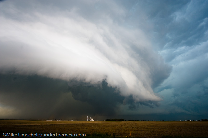
When I reached Hwy 83, I was greeted to a massive updraft area to my southwest. Tornado warnings were issued for storms farther north in the Leoti area. It turned out that there was a small cluster of non-supercell, landspout tornadoes. Oh well. I drove north on Hwy 83 to Shallow Water when the storm to my southwest was wrapping up significantly. This was turning into an HP beast, and I found myself in the notch of this thing. I got out of the car to take a few images, but I couldn’t do that long, as this storm was racing northeast at 50 mph.

As I drove north through Shallow Water, the structure to my southwest was fairly impressive with a nice circular, striated updraft area with a low-contrast lowering wrapping in rain to my west-southwest. Meanwhile, the wet RFD was racing north toward me fast. I made it to Hwy 96, but about 4 to 6 miles east of Scott City, I was being buffetted by 60 mph south winds in the RFD. This was really the beginning of the end of the excitement of this particular chase. The storm quickly became an outflow dominant mess as I was continuing east toward Dighton. I had some thoughts of just heading on home, but renewed updraft development on the old rear-flank gust front, which was now the leading edge of the synoptic dry intrusion, kept me just interested enough to continue following it. I followed it to Utica and eventually Ransom in northern Ness County along Hwy 4. There was a new mesocyclone to my southwest…

…and shortly after 3:00pm or so, there was a report of a tornado with this circulation, however I never saw this. Later on, I did see some photos of this feature, which was indeed a small, brief tornado. Unless you were in the right spot, you would not have seen this (and I was not in the right spot plus I was driving while this was occurring apparently). Storms moving 40 to 50 mph just do not give you the necessary amount of time to figure out what’s going on, especially when chasing solo. Plus the fact, the cloud bases were so low because the storm was moving into the area of low stratus that had stuck around all day up until that point. Not great conditions to photograph in. The best photography would actually be behind the storms looking at them from the southwest in the drier air. I entered Rush County and photographed some of the interesting convective underbelly of the storm in between the updraft area and the precipitation core. This was somewhat photogenic, especially with a green wheat field in front of me. This was around the 4:00pm time frame near McCracken.

I followed the storm as far east as the Hoisington-Russel longitude before giving up and heading back to Dodge City. I didn’t see any tornado on this outbreak day, but it was an interesting chase nonetheless.
11 images from this day’s shoot:
This is a WPSimpleViewerGallery
Great pics as always, Mike.
Comment by Dann Cianca — May 18, 2010 @ 10:47 am