(Sent by Mike’s Alltel Blackberry smartphone)
(Sent by Mike’s Alltel Blackberry smartphone)
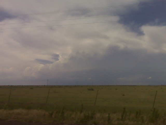
Looking nw from silverton tx
(Sent by Mike’s Alltel Blackberry smartphone)
We are going to hang out in Silverton, TX and monitor the north-south
convergence axis extending from Canyon south to about 10 W Plainview.
This is the most interesting area to us at this time. We see the
exploding storms east of Abilene, but that is way out of our
reach/target area. More later.
–
Mike Umscheid Photography
http://gallery.underthemeso.com
mesomike@gmail.com
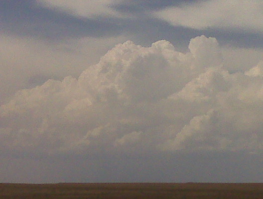
Watching some cu congestus developing to our south and southwest. This is a good sign for later on. We will be in silverton around or after 3pm.
(Sent by Mike’s Alltel Blackberry smartphone)
Our latest forecast thinking is that an area from AMA to LBB seems to
be the most likely region for quality surface-based storms after 4pm.
We are planning on a tentative target of Plainview, TX. It is clear
across much of W TX with only a few cirrus clouds evident. A weak
convergence line is setting up around the Plainview/Lubbock area which
is the area of most interest at this point. Very good deep layer
shear across this region with high CAPE as well as dewpoints in the
mid-upper 60s are poised just southeast of LBB. -Mike
–
Mike Umscheid Photography
http://gallery.underthemeso.com
mesomike@gmail.com
Pawnee City, NE Supercell & Oregon to Amity, MO Supercell
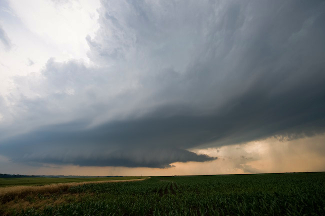
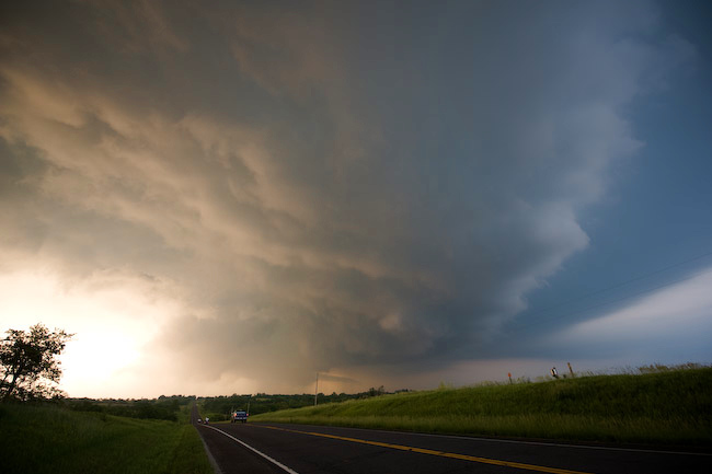
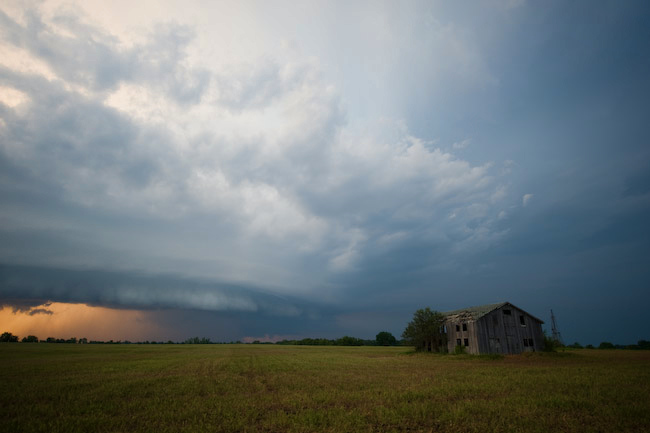
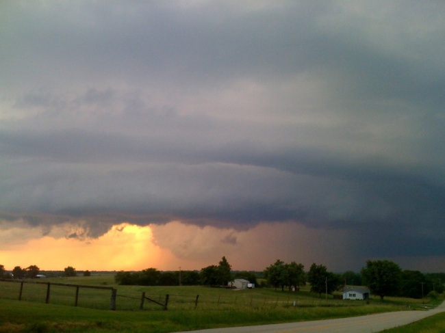
Robin and I left North Platte around 9:30am with a target of Hebron, NE in mind. I really didn’t envision us ending the day along the I-35 corridor in northwestern Missouri, though! …but it was worth it. We photographed two photogenic supercells, the first of which developing near the KS-NE border southwest of Pawnee City. This storm showed some signs of tornadogenesis early on when it was southwest of Pawnee City, however it struggled against some of its own outflow. Nevertheless, this was probably the most photogenic supercell I’ve photographed in southeastern Nebraska. We had a decision to make as we continued east on Hwy 8 on approach to Salem and Falls City — do we continue our intercept of the original storm or do we go after much better looking development east of us — a much more difficult intercept. The atmosphere made the decision for us. The southern supercell took over while our original storm was falling apart. The backside of the southern supercell was spectacular. The convection was like an atom bomb going off in front of us. As we crossed the Missouri River at Rulo, we continued to get closer, approaching the hook echo region of the supercell from the back side. We got into some of the precipitation as we approached Oregon. None of the precipitation was hail…. but as we drove into Oregon, that’s all we saw on the ground. Lots of giant hail. We didn’t stop in town in favor of trying to get ahead of the storm, but in retrospect, I wish we would have stopped to photograph some of these hail stones. They were absolutely huge, and we didn’t miss this hail fall by much — maybe as little as 5 to 10 minutes.
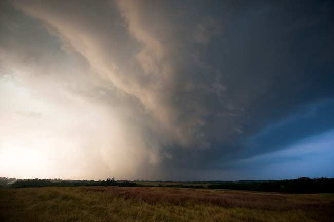
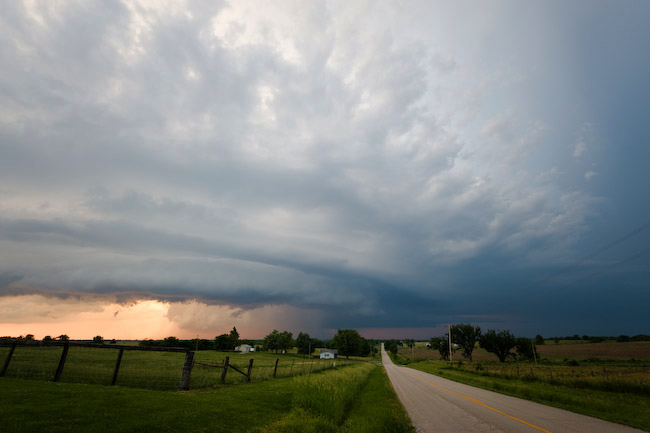
We reached I-29 with the hail core just barely to our east, and we managed to make it to Hwy 36 at St. Joseph where we continued east. We then headed north on Hwy 6 toward Clarksdale where we refueled and continued on our way. We stopped a couple miles south of where Hwy 6 curved to the east (about 6 miles west of Amity) where we photographed the supercell structure and wrapping rain curtains. The wrapping rain curtains to our NNE was significant. There was likely a substantial ground circulation amidst this wrapping rain curtain area, but it could not tighten up into a tornado circulation. It was close, though! We back-tracked to Hwy 36 and continued east, stopping at times to photograph the structure to our north. This was some of the finest storm structure I’ve ever seen this far east — certainly the best Missouri storm structure I’ve photographed. I was impressed — it was almost like chasing a storm on the High Plains — very contrasting colors with good visibility. As we approached I-35 it was getting to be close to 9:00pm and we had to end the chase given the drive we had to make back home. I had a very fun time these past 3 days chasing with my good friend Robin Lorenson. Certainly another reminder for sure how much easier it is to multi-task having a chase partner — since I chase solo so often. Thanks Robin! Some images from this chase below:

Evan Bookbinder and Jay Antle will arrive in Dodge City some time this evening in preparation for our first chase day, tomorrow, June 11. It appears our first day will not be too far from southwestern Kansas: Raton Mesa or just north of there, about a 3 to 4 hour drive from Dodge City. Thereafter, the pattern looks excellent for High Plains storm chasing/photography for much of the trip! More later!
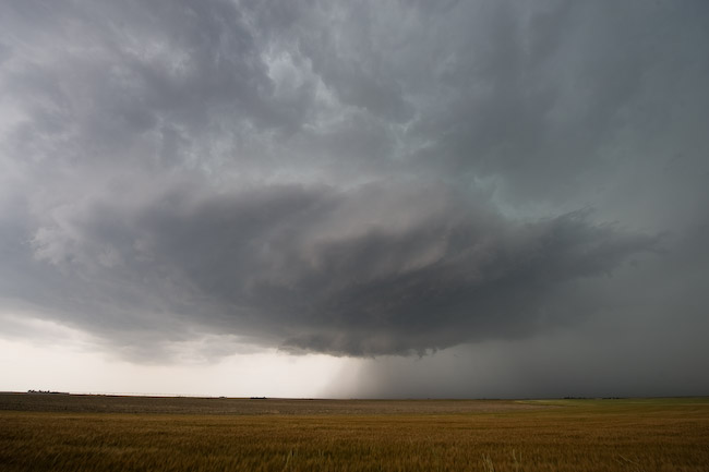
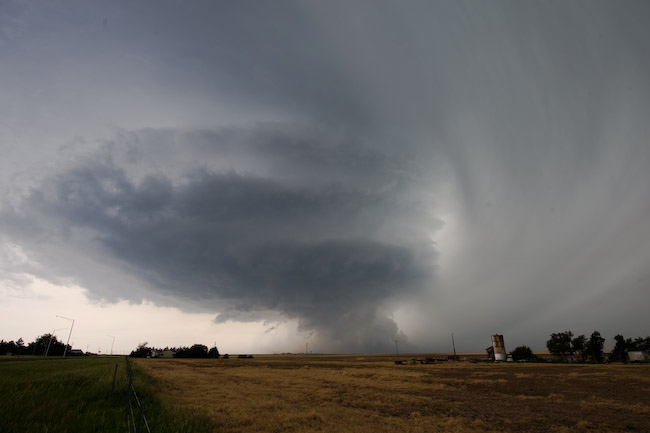
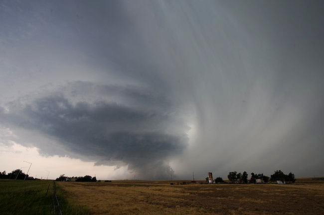
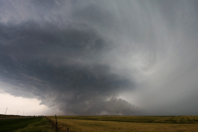
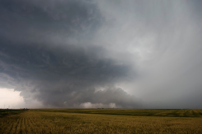
The One-Hour Pure Gentleman’s Chase — Dodge City, KS Supercell
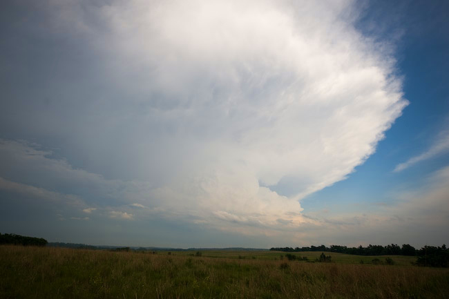
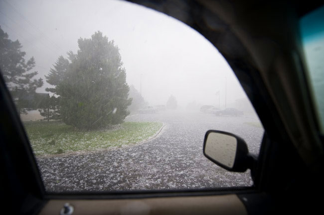
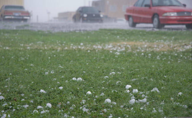
I worked the day shift on June 9th, and I got off shift at 4:00pm. I had planned all along to work overtime given severe weather development across our forecast area. That being said, by 4:00pm, there was nothing on radar across all of our forecast area, so I agreed to be called back if I was needed back for help. After a 20-minute nap, I got a call from Matt Crowther asking about a new storm developing southwest of DDC. I didn’t know anything about it at the time (about 4:30pm by now), so a quick glance at radar had me intrigued. It had a nice little shape to it and was moving in the general direction of DDC. So, I decided to go after it, only a 15 mile drive to the southwest from my duplex to the updraft seen in the first image. As this was moving northeast, I had to keep moving northeast too… back toward Dodge City. I took north bypass through the north part of town all the way to the US-283 junction, about 2.5 miles northeast of the Dodge City airport. It was at that time that one of my evening shift co-workers called me back in. It was at this time that I photographed images #2 through#5 below of the awesome updraft structure and menacing near-ground activity (in images #4 and #5, you can see the KDDC WSR-88D radome in the distance!). The tall precip shaft adjacent the updraft was beautiful! After I shot these images, I drove to the office…. toward this supercell. I didn’t make it to the WFO DDC driveway before the golfball size hail. Heavy and hard golfball to 2″ diameter hail pelted me as I entered the WFO parking lot. The last two images in this series below are from the WFO parking lot. What an awesome 1-hour, 30-mile round trip gentleman’s chase!!
Wow, what a fun chase. By far the most photogenic supercell I’ve seen
in Missouri. As much as I dislike the state, I gotta say, it put on a
nice little show this evening! We concluded chasing around 9:00pm
east of Cameron, MO and are heading back to Salina to drop Robin
off… and I will continue my drive into the wee-hours of the morning
to Dodge since I start back up on day shifts tomorrow at 10:00am.
–
Mike Umscheid Photography
http://gallery.underthemeso.com
mesomike@gmail.com
Robin Lorenson
Robin Lorenson Photography
www.robinlorensonphoto.com
660.287.0950
Powered by WordPress