(Sent by Mike’s Alltel Blackberry smartphone)
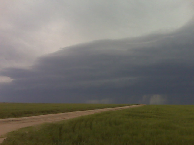
We are getting closer to some kick ass supercell structure!
(Sent by Mike’s Alltel Blackberry smartphone)
Finally catching the storms that are “tail end charlie” after driving
for awhile off of I-70. Two adjacent supercells west of us, we are
driving west currently for the intercept.
–
Mike Umscheid Photography
http://gallery.underthemeso.com
mesomike@gmail.com
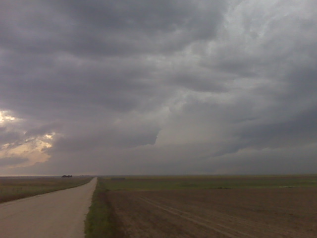
We are 11 N Arriba on farm roads photographing high-based storms with
photogenic lightning. The storms are about to ingest lower 60s
dewpoints, so we are hoping for a transformation of sorts toward more
significant severe storms. We are heading to I-70 and then east again
to stay ahead of this stuff. We realize we missed the tornado(es) in
SW KS. This was a misforecast on our part. We overanalyzed things,
but that’s part of chasing. Day is not done yet though!
–
Mike Umscheid Photography
http://gallery.underthemeso.com
mesomike@gmail.com
I think the best 2-hr play is to head north from Limon into Washington
County. SPC Mesoanalysis suggests 3000 J/kg CAPE just upstream of the
area where severe storms were to the northwest of Limon. Once these
storms hit the good moisture east of Limon, they may take on a very
different character. High CAPE and High Shear will likely yield a
very aggressive severe storm/supercell. Stay tuned!
–
Mike Umscheid Photography
http://gallery.underthemeso.com
mesomike@gmail.com
We are traveling west on I-70 to Limon, CO, which is about 40 miles
away as I type. There is a big supercell over the north side of
Denver we are watching on radar… and Verne Carlson’s video stream at
times. Pretty cool! Other storms south and east of Denver are
forming, but are still in mid 40s dewpoint air. Farther east =
greater moisture and CAPE, so we will probably wait in Limon for
things to become better organized as the activity from southeast of
DEN to COS is rather unorganized right now. More later.
–
Mike Umscheid Photography
http://gallery.underthemeso.com
mesomike@gmail.com
As I type, we are 30 miles south of Oakley, KS with a target of
northeastern Colorado in mind. Earlier this morning, we were thinking
Southwest KS into the OK Panhandle, however, we have decided to
re-target farther north and west given all the mid level cloud cover
with the upper wave across AZ and NM moving out fairly quickly. We
are now playing for upslope/elevated heating generated storms across
northeastern CO. The NAM and RUC suggest fairly aggressive convective
development late this aftn and evening across this area… and upper
tropospheric winds are actually a bit strong across eastern CO
(albeit, mid level winds just a shade lower, but still adequate for
supercells). There is good insolation across the target area with
morning stratus burning off. So we will head to Burlington, CO and
re-evaluate from there… however by that time, we may have a target
storm to chase to our west or northwest. More later.
–
Mike Umscheid Photography
http://gallery.underthemeso.com
mesomike@gmail.com
Kim to Pritchett, CO to Richfield to Hugoton, KS Long-lived supercell with brief tornado
Evan, Jay, and I had one long day. Intercepted the Kim to Pritchett, CO to Richfield, KS and beyond supercell. We observed numerous gustnadoes south of Pritchett, but as significant updrafting was beginning to occur above these dust whirlies. Soon, without much warning at all, a very nice and somewhat tall translucent dust tube extended from a compact dusty debris cloud upwad a good distance. This was no ordinary gustnado. We all three believe this was indeed a legit tornado, ~15 SSE Pritchett, CO at about 6pm MDT. Bookbinder and I got a few pretty good images, which will be posted by tomorrow morning at the latest. After this, the storm spewed out too much outflow, so we tried to blast east a good distance for structure. Some of the dust back in the storm was really opaque. Pretty hairy stuff. When we got to the KS border, we realized that getting gas was moving high on our priority list. We wanted to stay ahead of the storm though on our way to the next large enough town — Hugoton. So we went north on Hwy 27 from Hwy 51 to Richfield. We stopped a mile or so south of where Hwy 27 jogged east to Richfield to photograph incredible green vault color to our west. Beautiful. But we underestimated how close this was to us, and we figured we could get to the east jog in time. We miscalculated. We ate it. Golfball to 2″ diameter hail overtook us 6 miles west of Richfield. I have some spiders on the glass as a result. D’oh! We took Hwy 51 back south with some jaw-dropping structure to our west. Beautiful bell-shaped updraft with some of that vertical striations that most undoubtedly suggest 2.5″+ diameter hail. Then there was the dust. Wow. Inflow dust was just unbelievable. We drove through a couple inflow jets with less than 1/8 mile visbility. We eventually got out ahead of the storm enough on Hwy 56 to get more jaw dropping, menacing structure to the west-northwest with ground-scrapping lowerings/wall cloud. The kicker was the inflow dust jets — two of them streaming into the updraft from different locations and rising into the supercell. It was something I had really never seen before… two separate inflow dust jets going up into the supercell structure. Wow!!! At any rate, we continued to follow this beast watching a left-split race north as the main supercell was moving east. We thought these storms would merge between Hugoton and Liberal, but the left-split continued to race right on by. Our last photography location was west of Liberal with some shelf cloud structure in the waning nautical twilight. Met up with Scott Blair in Liberal for some fantastic McDonalds (sigh) since no other restaurant on Pancake avenue wanted to stay open past 10. Back to Dodge City tonight with more in store on this trip!


We are on our way home, concluding our last photo shoot west of
Liberal of the approaching supercell storm. We followed this thing
all the way from west of Kim, Colorado! However, we really didn’t get
back into a good road network to chase the storm until the Pritchett,
CO area… where we documented numerous gustnadoes. There was a brief
moment where a translucent, tube tornado occurred at the forward flank
of the storm. This was definitely a legitimate tornado, approac 15
SSE of Pritchett, CO at 6pm MDT. Afterwards, the storm became more
outflow dominant, and we followed it to far SW Kansas (Morton
County). We were in “find gas station” mode, and decided that Hugoton
was the best option… The supercell erupted again just west of
Richfield and we photographed one hell of a green looking vault
region.
–
Mike Umscheid Photography
http://gallery.underthemeso.com
mesomike@gmail.com
Powered by WordPress