North of Burdertt ks at 540pm
disclaimer: "The meteorological
views/forecast
thinking expressed are those solely of the author of this blog
and do not necessarily represent those of official National Weather Service forecast products,
therefore read and enjoy at your own risk and edification!"
and do not necessarily represent those of official National Weather Service forecast products,
therefore read and enjoy at your own risk and edification!"
May 6, 2010
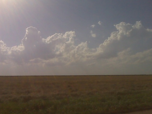
Cumulus developing at nose of heat axis 435pm 5/6
I decided to drive northeast of Dodge a little bit to monitor growing cumulus clouds around Hanston or Larned areas. I am not sure if storms will develop here or farther northeast, but will head up did this direction and watch. I must stay relatively close to Dodger City since I work at midnight.
[ Transcribed by MyCaption ]
May 3, 2010
Chase Trip Day Nine (May 2) Summary [13 images]
High-based storm & lightning near Grainfield, Kansas

(rest of images at the bottom of this post)
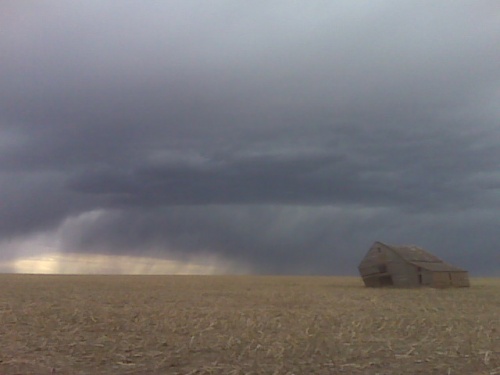
I was not expecting much on this day given dewpoint temperatures in the mid to upper 30s across much of western and central Kansas, however there were going to be storms based simply on the notion that temperatures in the mid levels…500 to 700mb… were still very cold. 500mb temperatures were going to be around -22 to -23C. The problem was that there wasn’t much of a focus for initiation to zero in and target on for chasing. Where was the best storm to photograph going to end up being? The environment looked equal just about everywhere from southwest Kansas into south-central Nebraska. I decided to use the RUC model as my guide as it was showing a corridor of southeast winds with a little bit better moisture… say mid 40s dewpoints… advecting back into west-central Kansas around Ness City perhaps. As it turned out, these winds never really materialized, and winds were quite light everywhere. The first storms developed farther north… north of Hill City, and this is where I was led. I made it to Hill City and eventually Norton, going after some briefly strong storms just into Nebraska near Alma. By the time I reached North I drove east to get into better position of these, but as I was doing this, those storms eventually waned with a bunch of other scattered weak convection developing to my southeast, south and southwest. Where to now? There was no need to be this far northeast when I could be a bit closer to home to photograph essentially the same convection. So I headed back southwest. I followed Hwy 9 west-southwest to Hwy 23 north of Hoxie as this areas was convecting better than any other, so I thought what the heck, I’ll just get closer to this stuff. I went south to Hoxie and eventually Grainfield when the “storm of the day” for me came into view to my southwest.
I wanted to get into a decent position for this cell, so I drove south on an unpaved county road southwest of Grainfield. I stumbled upon my shooting location of choice. A farm field with old corn stalks and an old barn making for a fantastic foreground subject. I used this old barn to my advantage — it certainly made the shoot! I set the D200 up with the lightning trigger and let ‘er go to work while I roamed around with the D3 to get some compositions of this old barn and the storm. I managed to get a few cloud-to-ground images from this storm with the barn off to the right. I think these compositions with the storm, lightning, and old barn work best as 2:1 crops in post-processing, which is what you’ll see in the album of images from this shoot. One of the frames even has me in the shot, which actually kinda works in a way for perspective! I felt pretty satisified with this and decided not to get greedy and begin my way back home. I went south on Hwy 23 to Gove only to find that it was closed south of Gove. I was forced to turn around and head back to I-70, but the next storm that developed in the cluster was producing some decent lightning frequency, so I gave it one more attempt to photograph just northeast of Grainfield this time along Hwy 23. I was at this location for probably 15 or 20 minutes before the lightning activity waned. At that time I decided to finally head on back to Dodge. This was exactly the kind of shoot I was hoping for, but honestly wasn’t expecting. I think one or two of the images from this day are Portfolio-worthy.
Begin: Dodge City, KS (home)
End: Dodge City, KS (home)
Day Nine Mileage: 431 mi.
Trip Mileage: 4085 mi.
13 images from this day’s shoot:
This SimpleViewer gallery requires Macromedia Flash. Please open this post in your browser or get Macromedia Flash here.
This is a WPSimpleViewerGallery
This is a WPSimpleViewerGallery
May 2, 2010
Chase day may 2 concludes
I am on my way home after what ended up being a rather successful photography evening despite the dismal look earlier on. I got several daytime lightning images which turned out quite well I think. So, I am quite happy, thus likely ending Chase vacation number one, of 2010. More later.
[ Transcribed by MyCaption ]
chase trip update 5/2 4:35pm
I’m currently on a wild goose hunt on what certainly appears to be my
last chase day of this particular trip. I was suckered all the way
north to Norton by the initial convective line. That stuff quickly
turned to crap after showing some hail indicators on radar with some
decent looking Cbs. Since there is uniform CAPE (meager) and shear
pretty much everywhere across this region… and the lack of a
substantial convergence area… I will be making my way back toward
Dodge City… since the convection down there closer to home is about
the same as up here… I can photograph that stuff closer to home…
if there is even anything worth photographing. I will have to get
lucky with golden-hour light around sunset with hopefully more of the
isolated stuff with some sunlight. Ahh well. I gave it a shot I
guess.
Chase Trip Day Nine (May 2) Forecast
Most likely the last day of the chase/photography trip — Western Kansas. I am at home in Dodge City to begin today, and it appears I do not have to go very far at all for potentially photogenic storms. Some residual low level moisture with dewpoints in the mid-40s were located across central Kansas late this morning. Surface winds are expected to become southeast or east-southeast which may draw some of this moisture back west into portions of southwest Kansas by late this afternoon. The latest 15z RUC suggests that strongest surface convergence will occur in west-central Kansas perhaps around Ness City to Dighton, and it develops some convective QPF in this area by late this afternoon/early this evening. This is an extremely marginal day for strong/severe storms, but an isolated hail storm or two cannot be ruled out, and could be somewhat photogenic. I will likely leave Dodge around 2:00pm or so, or perhaps later based on hourly analysis.
This will be the last forecast post of my storm chasing/photography vacation unless things change in the models — mid level temperatures will be warming with no increase in moisture. A front will move into western Nebraska late Tuesday, but there won’t be any moisture to speak of… not even mid-upper 40s dewpoints more than likely. I will be coming back to Dodge City after today’s chase and spend the final two days, Monday and Tuesday, at home getting ready for the start of upcoming midnight shifts which begin Wednesday Night.
Chase Trip Day Eight (May 1) Summary [21 images]
Northeast New Mexico/Southeast Colorado Snow Showers.

(rest of images at the bottom of this post)
May 1st, which was day eight of my storm chase/photography trip, was actually quite a fun and interesting day photographing scattered snow showers with ambient surface temperatures in the mid 40s to lower 50s. Given the continued dry environment in the low levels… with dewpoints in the mid to upper 20s… these showers would allow temperatures to wet-bulb down into the mid to upper 30s. The environment was characterized by very cold temperatures in the mid-levels for the second day in a row with 500mb temperatures of -22 to -24 C. All it took was just a few hours of insolation after sunrise to get the initial cumuls to develop over the higher mesas across northeastern New Mexico. Knowing this in advance with the models all showing convective precipitation developing by 18z in this environment, I decided to depart Clayton during the late morning hours for Capulin Volcano to do some sightseeing and photography, knowing very well that I would have some interesting sky to potentially photograph to go along with the landscape. It ended up working out just as I had hoped. I arrived at Capulin around 12:30pm or so, wandering around the rim of Capulin on the 1-mile loop rim trail photographing the varioius showers. These showers were so small, it actually made for better photography, because I could fit the entire shower… and sometimes two… in one ultra-wide angle frame. One of the stronger showers to the west developed a small anvil and even some mammatus. Showers with contrasting white snow shafts against an otherwise fairly blue sky…and warm-colored ground…made for good images. I left Capulin and headed north to Folsom then briefly northeast from there to get under a heavier shower that was along and just south of Hwy 456. I started to hit the moderate wet snow about 3 or 4 miles east of the Hwy 551 junction. It snowed just heavy enough to create a light white blanket on mainly elevated surfaces. I found a small row of hay bales which made a great subject with a light coating of wet snow on top. I then turned around and decided to head west along Hwy 72 across the Johnson Mesa to Raton. I then went north to Trinidad and was hoping to stop by for a quick bite to eat and a beer at the Trinidad Brewing Company, however apparently this place is now closed. Since the brewpub hunt was a bust, I continued my merry way back to the east on Hwy 160 stopping occasionally to photograph more of the showers. One stronger cell developed just north of Kim early in the evening, and I even chased this for a brief time before it died. All in all this was quite a fun day of shooting!
Begin: Clayton, NM
End: Dodge City, KS (home)
Day Eight Mileage: 461 mi.
Trip Mileage: 3654 mi.
This SimpleViewer gallery requires Macromedia Flash. Please open this post in your browser or get Macromedia Flash here.
This is a WPSimpleViewerGallery
This is a WPSimpleViewerGallery