This was a chase day where two key "decision point" circumstances arose… both of which the decision I made ended up being very good. First of all, I left Clayton, NM this morning with my target being way to the south… about a 4.5 hour drive to near Midland as it appeared the best juxtaposition of CAPE/instability/shear was going to be in this area coinciding with a boundary as well. Even when I left, I realized that I was going to miss out on another "Raton Mesa" opportunity as I figured storms would form there once again between Raton and Clayton with adequate shear in place for interesting storms. Nevertheless, I left about 10am CDT to go south. I stopped at the town of Channing and looked over the latest data… since the Raton Mesa area was still nagging at my brain…something about this area in Northeast NM that I really love. After mulling it over more… I decided then to continue south and not turn around. I then stopped again at Hereford… which is about 130 miles south-southeast of Clayton. I perused data again… more interrogation of the NAM and RUC models, satellite imagery, surface obs/tendencies. I finally came to the conclusion that, okay, maybe heading this far south was not the best idea… as I was having a very hard time thinking there would be any better photogenic storms down there then there could be along the Raton Mesa area. It also looked like things were going to take shape much farther south… as far as any tornado threat would go. It was about 12:20pm or so when I turned around… it was a 260 mile round-trip waste of gas money, but that’s storm chasing.
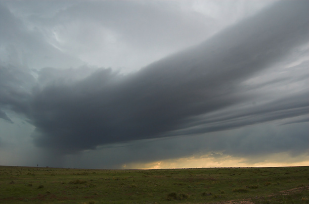
This was turning point #1. By the time I reached Dalhart, storms were already forming northwest of Clayton and this would be the area I would target. After refueling and getting a bite to eat, I continued north on a road (Hwy 370) north of Clayton with beautiful landscape and storms to my northwest through southwest. The storm of most interest to me was to the northwest and I continued north to stay ahead of it. I meandered east on a county road watching this storm to my immediate northwest take on good structure. The storm had a large "horseshoe" updraft base and in time continued to look more supercellular in appearance. Some of the mammatus overhead was becoming more defined as well. At its best, the structure of the storm revealed multiple-tiered structure at its front flank with nice, clean contrast. I eventually made it into adjacent far western OK Panhandle west of Wheeless. Another storm to the northeast of this primary storm was getting its act together as well… and eventually I watched this amazing inflow band develop just to my northeast. This thing stretched for miles and miles… fantastic! This inflow band eventually became part of the new storm updraft to my immediate north… just to the northwest of Wheeless, OK. For a time I had two adjacent storm updrafts that I was able to get in one photo. In time, though, the structure was becoming more shrouded in rain. I eventually stopped photographing this storm and headed back south to US-56 at Felt, OK. I was able to re-establish internet connection to see how this was looking on radar… and I meandered west towards Clayton where I stopped for awhile to figure out what I wanted to do next.
Turning point #2. Go home or continue chasing/leave option open for chasing tomorrow? Basically, spend more money on another night’s motel room or not was my main decision. After mulling this over for about 15 minutes, I decided to head back into Clayton. This ended up being a wise, wise move. I noticed new storms forming along a northwest-southeast orientation to the northwest of Clayton, and I figured that there might be some photo ops to the southwest of these storms where there wasn’t any rain. I drove northwest on US-64 towards Mt. Dora and Des Moines, NM just to see "what up". Well, eventually, even newer storms were forming immediately west of this previously mentioned new stuff and was taking a track towards Des Moines… so I continued to get closer… eventually seeing a rain-free base to the northwest.
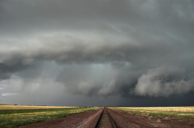
I approached this area fast, eventually getting close enough to find a pull-off on a county road (Weatherly Road). I happened to be adjacent a rail-road track which proved to be a very interesting photography subject with the storm. The storm began to take a more interesting shape with a curved updraft region just south of the heavy precip… almost like a hybrid HP supercell/shelf cloud type structure. What was most interesting, however, was what was going on immediately east of this "shelf cloud" looking updraft region. Low cloud material was streaming west to east…while scud tags/updraft material from the primary updraft was rotating in a broad cyclonic sense from west to east. A forward flank meso was developing right in front of me to the immediate north, and it was taking shape fast! A rear-flank downdraft feature developed as well with rotation increasing quite a bit! Holy cow, I wasn’t expecting this! The rotation eventually came to a point that I thought I might get really, really lucky and perhaps spin up a brief tornado from this circulation! Eventually, a nubby looking nascent funnel cloud did develop from the center of this circulation, however, but unfortunately the air was too chilly from the outflow of this storm such that it was overwhelming this circulation and the tornadic threat waned fairly quickly. It was great watching this all unfold in just a few minutes time. I backtracked to the southeast… then went west and south on a county road from Mt. Dora to stay ahead of the now outflow-dominant storm. I was able to get a few more decent photos of the storm during this time, until the cold outflow of the storm pretty much took care of the photogenic aspects of it. I reached Hwy 56 and made it back to Clayton where I shacked up for the night at the Days Inn and had a nice dinner and beer at the Eklund Saloon. Very fun chase!
Storm takes on supercell characteristics about 15 miles north of Clayton, NM 
Near the New Mexico border with the Oklahoma Panhandle to the north-northeast of Clayton

Beautiful inflow bands streaming into an updraft west of Wheeless, OK
Fairly strong rotation with a nascent funnel cloud looking up the railroad tracks near Des Moines, NM

Supercell structure with a faint funnel cloud looking to the north near Des Moines, NM
Love these pictures Mike…Awesome composition with the train tracks leading into that rotation!! Keep up the great work.
SCM
Comment by Mike Shumate — June 5, 2007 @ 1:52 pm