Wow, what awesome structure! This was a complete impromptu chase, as I am at the tail-end of midnight shifts and didn’t wake up until 1:30pm. I was actually awaken by a colleague at work calling to alert me of a storm I might be interested in chasing… since I *could* chase until late in the evening given the close proximity to Dodge City. After looking at just a few things, I got a quick bite to eat, fueled up the car and took off north towards Wakeeney where a supercell was already in progress. By the time I got to Wakeeney, the meso with this storm was moving south-southwest towards the Quinter-Park, KS area. This storm was becoming increasingly undercut by cool outflow as I stayed ahead of it south of Park. I drove about 9 miles south on an unpaved road then had to go west to Gove to find paved roads again with heavy precipitation coming too close to me. Another storm to the immediate south was exploding to the southeast of me in southeastern Gove County.
I continued south from Gove on K-23 with strong northeast outflow winds buffeting me. The new interest was indeed this southernmost storm now to my southeast…and it was showing supercell characteristics on radar with mesocyclones indicated. I continued all the way south to Dighton when I headed east a couple miles before continuing south to stay ahead of what was now a very impressive HP supercell! I went south on the Alamota unpaved road (it was well-grated), but I didn’t want to venture too far away from paved routes. I knew though that if I stayed ahead of the precip core to its south… I’d be fine as no other storms were now developing ahead of this mature supercell. I stopped briefly several times to capture some images of this storm. Lightning was incredible with all sorts of in cloud, cloud-cloud, and cloud-ground lightning. The sound of continuous grumbling in the upper reaches of the storm was incredible! I eventually came to another well-grated east-west unpaved road and went east into extreme northwestern Hodgeman County where I was now watching incredible structure with that aquamarine-green scary color to my northwest. Inflow winds at this location were 40-50 mph from the south-southeast!! Wow. Unfortunately with HP supercells, getting a visual of any tornado is next to impossible even if there is one. The thing with this storm was that the roation was somewhat broad… but very intense at that.
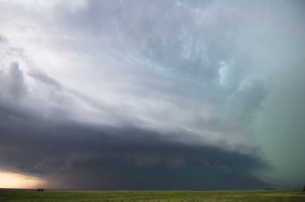
Eventually, the tiered updraft structure became very photogenic. What a treat! I continued south…stopping every few minutes to get more photos of the structure…eventually reaching K-156 between Kalvesta and Jetmore. I decided to head back west then south on more unpaved roads. The storm was in a state of transition now and the structure wasn’t as good as it was about a half hour prior. The storm however was still incredible with lightning frequency very high. I eventually made it into extreme southwestern Hodgeman County to the southeast of Kalvesta about 6 miles or so…when the structure was taking on fantastic appearance again…with multiple tiers of rounded banding. Awesome!! I took quite a bit of photos with my new 12-24mm ultra-wide angle Nikon lens. Eventually, I made it south to Howell on US-50 and called it a chase and headed back home… which was a whopping 6 miles away! How convenient. This was probably the best HP supercell structure I’ve seen in several years chasing… probably a "top-5" HP supercell storm in terms of ferocity and structure. Below are a couple of photos:
HP Supercell structure looking west about 15 miles south of Alamota, KS at around 6:10pm CDT:
HP Supercell structure looking west-northwest near Kalvesta, KS at around 7:10pm CDT:
