36 degrees in North Platte with "chunky" rain. The radar loop out of Goodland, KS is very impressive with significant precipitation echoes across all of northwest Kansas. The temperature continues to slowly drop here in North Platte. It is snowing and 32F in Ogallala about 50 miles west of here. I estimate the rain/snow line to be probably 20-30 miles west of North Platte as of 6am. Below are a couple more model forecast snowfall amounts for this storm, the first is the "Dev" RUC20 model and the second is from the NAM. Both are suggesting 10-12" here in North Platte. The NAM shows a significant 20" bullseye across north-central Nebraska:
and do not necessarily represent those of official National Weather Service forecast products,
therefore read and enjoy at your own risk and edification!"
April 10, 2008
Spring Snowstorm Chase: April 10, 2008 [post 4]
10-12" forecast ending 10pm Thursday night from the latest "Dev" RUC20 model! The RUC is also showing sustained winds in the 25-30kt range. Given the quantity of snow expected, am thinking that at least near-blizzard conditions will be likely tomorrow afternoon!
April 9, 2008
Spring Snowstorm Chase: April 10, 2008 [post 3]
Below are a few images I put together of some of the model forecast meteorological fields:
Below are a few images of official National Weather Service watches/warnings and a point forecast for North Platte (per the gridded forecast output for North Platte, the North Platte NWS office is calling for 6-7" in North Platte):
Spring Blizzard Chase: April 10, 2008 [post 2]
Arrival in North Platte. I’m staying at the Quality Inn along I-80, arriving about 9:30pm or so. It is currently 41°F here and is already snowing west of here in Sidney. The motivation for this trip was to experience one last good winter storm, and the timing fits perfectly with my days off work. I am not due back to work until Saturday morning. The peak of the storm is expected to be roughly Noon tomorrow (Thursday 10th) through Midnight or so. A classic upper low bombing out over western Kansas puts this portion of the High Plains in the cross-hairs for 10+ inches of heavy, wet snowfall. There’s some question about how much this snow will blow around (versus plastering against everything) given how wet it is expected to be, however, north winds will increase to 25-35mph tomorrow afternoon with frequent gusts above 40mph. This could be quite fun!
I chose to do this versus severe local storm chasing for the simple reason being I could not have made it down to the Abilene, TX area earlier today immediately following my last Midnight-8am shift. If I had a chase partner that could leave with me right when I got off work, I could have done it, so I could sleep on the way to the target, but it was not to be. Also, I had considered giving Thursday a shot for low-topped severe storms near the surface low, but am not overly excited about the prospects of seeing anything worthwhile — that being said, I think there could be an interesting low-topped supercell or two very near the deepening surface low tomorrow perhaps along the KS-NE border. I really liked the looks of the winter weather aspects of this system, so I thought "what the hell" and decided to head north to a location I thought might get plastered given the track of the 500mb and Surface lows. So I chose North Platte. I’ll post a couple weather maps in my next post.
Spring Blizzard Chase: April 10, 2008
I’ve made a very impromptu decision to drive to North Platte, NE to be a part of what looks like an amazing Spring snow storm across much of western Nebraska. I will arrive in North Platte about 9pm or so, and plan to be there through Friday. The storm will be at its height tomorrow (Thursday 10th). Given it’s spring time and temps not being too far below 32F, major highways should be cleared by late Friday, allowing me to get back to Dodge in time for "back to work" Saturday. This looks too good to pass up, and I love an opportunity to witness heavy snow and wind (and possibly thundersnow!). I’ll provide fairly frequent updates with snow amounts around North Platte, as I’ll be staying at one of the hotels along I-80.
March 24, 2008
Late March update: A potpourri of stuff
Greensburg talks
My "Greensburg tour" is going pretty well up to this point. Venues I’ve spoken at include Wichita, Aurora CO, Lawrence KS, Colleyville TX, Pratt KS, and Hampton VA. The Colleyville, TX talk was the TESSA National Storm Conference that is held every year in early March. It was good to meet new faces and see friends I haven’t seen in awhile. The Al Moller tribute and dinner was awesome, and I am glad I was there for it. Two days after I got back from Texas, I flew out to Virginia, as I was invited to speak at the Virginia Emergency Management Conference. They were interested in having a meteorological perspective on the event to go along with the emergency management side of things. Matt Mercer, the southwest KS regional coordinator for KS Homeland Security spoke about the Greensburg event from that perspective; he’s also from Dodge City. Two more talks left: Lincoln, NE "Central Plains Severe Weather Symposium" the weekend of March 29-30 and the following weekend April 4-5 I will be at Valparaiso, IN for the Great Lakes Meteorology Conference. I will also be taking part, to some degree, in Greensburg anniversary festivities the weekend of May 3-4th.
Utah-Colorado trip pics
I am about halfway done processing and uploading pics from my Utah-Colorado trip a little over a month ago. If you’ve been a regular to my website, you’ll notice some changes, which I’ll discuss a little bit more about below. Visit the "Moab 2008" link you see at the top. I hope to get the rest of the albums uploaded by the beginning of April, depending on the amount of free time I have.
Lightroom "Flash" albums & new "Collections" page
All new recently-shot images have been processed and uploaded through Adobe Lightroom. I’ve done this since about November, with the idea of hopefully getting a lot of images added faster. I’m using a very generic Joomla CMS template, and I’m fairly satisfied with the organization. I will not be deleting any albums from my current "Gallery", but many of the albums will eventually become "hidden", only accessed through the Collections front-end. "Gallery" will still exist, it will just evolve into my portfolio of high-end images only, with the plan to set up some sort of online print ordering interface within "Gallery". At least this is how I envision it for now. I’ll try to keep everyone posted.
Storm chase trip?
I put in for some time off at the latter part of June, although I’m not sure if I’ll get it or not — so it is still up in the air whether I’ll be taking a 2008 chase trip. If I do, I’ll probably tag along with either Jay Antle or Vince Miller again, we’ll see. I finally got a new Jotto Desk for my vehicle, so it will be a lot easier for me to have a chase partner in my Jeep, although I’ll primarily chase solo throughout the year except probably during my chase trip, if I take one.
March 3, 2008
Chase Acct: March 2, 2008 (Western OK)
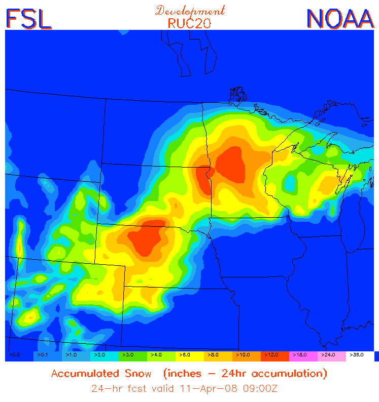
March 2nd was my first chase of the 2008 storm chase season. I wasn’t planning to chase this day, given the fact that for awhile it looked like the best setup for supercells would be too far south. After awaking early in the morning Sunday, and upon looking at some initial data concerning the day’s severe weather threat, the focus had really shifted to the north where a pronounced warm ridge in the low levels would advance northward into southwestern Oklahoma. Mid 50s dewpoints were to be expected to the west and northwest of this warm nose, providing about 1000 to 1500 J/kg of surface-based CAPE. Since it appeared there was a reasonable chance at supercells within 4 hours of Dodge City, I decided to make it a chase, and left around 8:30 for a target around the Mangum, OK area in the southwestern part of the state.
I arrived in Sayre, OK early in the afternoon to clearing skies with bubbling cumulus to my south. It was warming well into the 70s to my immediate south with a few lower 80s around Childress, TX. I decided to hang out there in Sayre until things started to develop. Between 1:30 and 2:00pm, the incipient storms were developing just to my north. It was tough to decided what to do — whether to go after the first "blips" on radar, or just meander east and wait for more stuff to develop down the line, which I expected. There was uniform instability/shear pretty much across all of western Oklahoma, which made picking a storm largely a guessing game, or whatever the most interesting echo was that was the easiest intercept. I knew that anything developing north of me would be extremely difficult to intercept given the northeast storm motion of 35-45 mph. I headed north out of Sayre then east towards Elk City. Some of the updrafts to the north caught my attention but they were already 15-20 miles north of me and rapidly moving away. I drifted east a little bit on I-40, stopping occasionally to figure things out. There were numerous small cells — storms of little organization. It was a mess to try and sort through.
By 3:15, I made it as far east as Clinton, and decided to head south down Hwy 183. I made it all the way to Rocky, south-southwest of Cordell, and finally off to my west was some pretty decent updraft structure with one of the storms closest to me. I followed this storm, stopping occassionally for photos, from 3:45 to 4:30 when I reached a location about 11 miles east of Rocky. The storm attained some rotation and had fairly decent updraft structure including a rear-flank downdraft. As the storm was heading northeast, I decided to continue following it north on Hwy 54. A tornado warning was issued for the storm between 4:45 and 5:00 for strong radar circulation to my northwest. There was indeed broad rotation at cloud base with pretty impressive clear slot/rear flank downdraft structure, but I could never discern what I would consider rapid rotation. I continued east on Hwy 152 to Eakly to stay ahead of the storm and put myself in position to intercept the next storm (which was also tornado-warned) immediately to the south. Instead, after looking back again to the northwest and seeing a very ominous looking "mass" of cloud near the ground wrapped up behind the rear-flank downdraft, I decided to head north on Hwy 58 at Eakly. What followed was a very interesting mass of cloud that very much resembled a large funnel cloud or even multiple funnels protruding to the surface in the proper location for tornado development behind the clear slot. I was too far away and driving while this was happening (trying to get closer), so it was very difficult to ascertain what was going on. Briefly, it certainly looked like a laminar "cigar" shaped funnel developed, descending quite low from cloud base. It was changing shape quite a bit though. It really appeared that tornadogenesis was really trying hard here, probably somewhere between Weatherford and Colony. Eventually, this feature waned and the storm croaked as I headed north back towards the I-40.
This would be the extent of the day’s chase pretty much. Since it was still fairly early (only 5:30pm or so), I decided to head east to get ahead of the line in hopes of getting decent shelf cloud images. I continued chasing until about 6:45 or so, awaiting the line of storms just outside of Minco. The shelf cloud structure was less than inspiring, unfortunately, and it was also too dark for much photography. Most of the lightning was embedded in the core of the storms, so there wasn’t much opportunity for lightning photography either. The chase was done and headed to Clinton to stay the night. I didn’t feel like driving for 3 hours back home in the dark against a 40-50mph head wind.
March 2, 2008
Project Greensburg & 2008 First Chase!
Last Night was another night I won’t forget. ~70 local residents, many of which from Greensburg, showed up at the Project Greensburg storm chaser fundraising event in Pratt, KS. I was invited by Greg Stumpf and Mick Ptak, the event organizers, to give a 15-20 minute presentation on Greensburg in between the showing of chapters from the "Storms of 2007" DVD. A $3100 check was presented to Greensburg Greentown from profits of the previous year’s DVD. 70-80 copies of the 2007 DVD were sold at the event last night at Pratt Community College, all the profits of which will also be donated to Greensburg Greentown. A few other showings are planned, including the Central Plains Severe Weather Symposium in Lincoln, NE at the end of March.
Believe it or not, today is a chase day! I have the day off, and today is a good day to get the storm chasing feet wet again. A strong storm will eject out of New Mexico later on today and it looks like the best focus for possible supercell storms will be west central or southwest Oklahoma. The tentative target right now is the Mangum-Altus area. Storms may develop fairly early, which for early in the season, may not be a bad thing given early sunset. I plan to depart around 8:30am or so. I will put the website into "chase mode" probably by early afternoon or so.
February 24, 2008
Colorado-Utah trip, Feb 2008 (back home)
I got back home from my vacation earlier on today about Noon or so. I had to drive through a little dense fog between Salina and Great Bend… but as I continued towards home, the fog rapidly lifted, skies cleared, and the temperature shot up rapidly to the lower 50s — a nice little welcome home. The other "nice little welcome home" was a refrigerator full of rotten food. My damn fridge went on the fritz while I was out of town. I hope to get it fixed tomorrow. Other than that, nothing much to report — this will be the last post of this trip. I’ll post again when I get some of the initial photography albums uploaded from Utah. It might take a little while though
although I’ll try to work on them as fast as I can.
February 23, 2008
CO-UT Trip, Feb 2008 (Day 10)
Today is the 23rd, and the friggin snow has stopped me here in Salina. I should have checked the weather closer before I left Lawrence — I could have just stayed there. But nope, was anxious to get home and along the way, I had run into the snow near Junction City. In short time, the snow was coming down fast and furious — rapidly collecting on the interstate. Prevailing speed had slowed to 35-40mph on the interstate, and by the time I reached Salina, I was exhausted from the tight-gripped, white-knuckler. It was snowing hard. A quick 2-3" had accumulated by the time I reached Salina, and I said enough was enough and decided to pack it in for the night — I’m just flat tired, even though the back edge of the snow is not that far away. So here I am at the Super 8 along I-70… I’ll get up early in the morning and resume my trek back home to Dodge.
The Douglas County EM Severe Weather Symposium went quite well. Speakers were myself, Jennifer Stark (the Warning Coordination Meteorologist at Topeka), Jon Davies, and Chris Novy. At the end of the symposium was a roundtable discussion centered around topics such as the new Storm-based warnings by the National Weather Service and other topics such as "tornado emergencies". It’s always great to have a discussion like this among the spotter community (the audience), National Weather Service meteorlogists like myself, and on-camera meteorologists from the local media. Several representatives from the Topeka and Kansas City market were there including Joe Lauria and Bryan Busby. I’ll make another brief post tomorrow when I get home in the morning and perhaps add another couple images from the Utah trip.


