Sitting in Childress at this time about to take off for Lubbock area where I’lllikely spend much of the afternoon. RUC and NAM suggest near 2000 J/kgto develop in the northward advecting moist axis through West TX. Del Rio morning sounding shows pretty good moisture which is already advectingnorthwest just off the surface. Midland sounding had highest mixing ratiojust above ground level with near 50F. I think by 00 UTC, there shouldbe widespread upper 50s to near 60 dewpoints from Midland to Lamesa toSnyder…perhaps as far north as Lubbock. I think the best play is right atthe nose of the good low level juice… so my initial target isLamesa-Post-Snyder area for initial 22-00 UTC development…thentowards Jayton-Rotan-Aspermont area later in the evening.
and do not necessarily represent those of official National Weather Service forecast products,
therefore read and enjoy at your own risk and edification!"
April 26, 2008
Chase Forecast: April 26th – West Texas [post 2]
April 25, 2008
Chase Forecast: April 26th – West Texas
I will be driving to Childress, TX after work this afternoon to set up for a Saturday chase in West Texas. Low level moisture will return back north tomorrow across West Texas with dewpoints reaching upper 50s to near 60 as far north as northwest Texas. Another shortwave disturbance will dive southeast out of the Rockies tomorrow putting West Texas in substantial forcing for ascent and subsequent deep, moist convective development. Surface-based CAPE values may reach 2000 J/kg by late afternoon. At this point, I’ve got my eye on an area between Lubbock and Childress, but may travel as far south as I-20 to Abilene. The key tomorrow is to a) be close the advancing low level moisture and b) remain well south of the charging cold front. I think both should be accomplished with relative ease.
Chase Acct: April 24, 2008 (Northwest KS)
I was able to leave work right at 4pm for yesterday’s chase. As Iposted in the FCST thread, the area I was most interested in was alongand north of US-24 to Nebraska. I met up with Tony Laubach and VerneCarlson for a short time east of Ness City as some cumulus weresomewhat intriguing at the nose of a small scale mixed-out warm plumewhere convergence was locally maximized. I told myself that if the Cudidn’t look any better in 45 minutes, I would bolt northwest where Iwas extremely confident there would be a sustained surface based severestorm where the deep tropospheric forcing was much better acrossNorthwest KS. The first storms were developing with some decent echoesaloft around Goodland, and at that point, I continued north toWakeeney, then northwest to Hoxie, to my first stopping point south ofRexford. The southern storm had some nice shape to it and appeared tobe supercellular, but it was small. Of interest at the time was alarger mass of convective updraft due north. These two storms mergednorthwest of Rexford, and the storm really took off. Of course, it wasgetting well into the evening by this point, but the supercellstructure was quite fine…although high based. The westernmost portionof the storm revealed an interesting lowered feature, which I guess youcould call a wall cloud, but there was a lot of outflow dust beneath itlooking roughly west from near Hwy 23-83 junction at Seldon. It was toodark for handheld photography, so I tried my best to get the tripodsetup for some 1-3 second wide angle exposures amidst strong eastinflow winds and blowing dust.
Now,idiot me, I continued east on Hwy 9, instead of joining the massesheading south on 23. I guess I was expecting the storm to move more dueeast…and from my perspective due east of the storm, the structure waspretty good from a photography standpoint. I stopped briefly about 6 WNew Almelo for more long-exposure photography on the tripod before Ibegan to get pelted by quarter-size hail. Looking to thewest-southwest, the supercell structure looked pretty darn good fromthis vantage point on Highway 9, so the decision to head east insteadof south I guess wasn’t so bad after all. Of course, by the time I gotfar enough east to reach a south option again at Hwy 283, it was dark,and there was little if any decent lightning illuminated structure. Ireached Hill City amidst blaring tornado sirens, continuing southhopefully far enough south to get out of the cloud canopy so I can geta nice distant view of supercell structure. It really wasn’t to be. Idid stop at a high spot south of Hill City where other spotters andchasers also stopped, but by this time, the supercell circulation waseast of Hill City. There were a lot of lightning illuminated "hangydownies" just west of where the radar had strongest rotation near HillCity. There was nothing more to shoot of interest photography wise, soI headed south towards Wakeeney in hopes that maybe a very distant viewof the storm could be interesting, but even that wasn’t all that wascracked up to be, so I continued to Wakeeney, ate dinner, and headedhome. A fun little chase. Below are a few images (all 12mm wide angle):


April 20, 2008
Facebook problems & Royal Flush
This post is mainly directed to my Facebook friends. Over the past week or two, I have had spam sent out through my Facebook account on more than one occasion to pretty much everyone on my Friends list.. I apologize for this nonsense.. I have de-activated my Facebook account for the time being until I completely clean up my computers, freeing it of all spyware, trojans, bots, etc. that may exist. I’ll get the mess sorted out over the next couple weeks or so.
On a completely different topic, last night I hit my first Royal Flush on video poker at Ameristar Casino last night. I was out with my bowling teammates as we are in KC this weekend for the Kansas state bowling tournament. I was playing max credit (thank god), but was only on a 10-cent machine, which wasn’t a progressive machine ![]() , so I won $400. I held a "3-to-a-Royal" first hand, and got the last two cards for the Royal. Pretty cool!
, so I won $400. I held a "3-to-a-Royal" first hand, and got the last two cards for the Royal. Pretty cool!
April 10, 2008
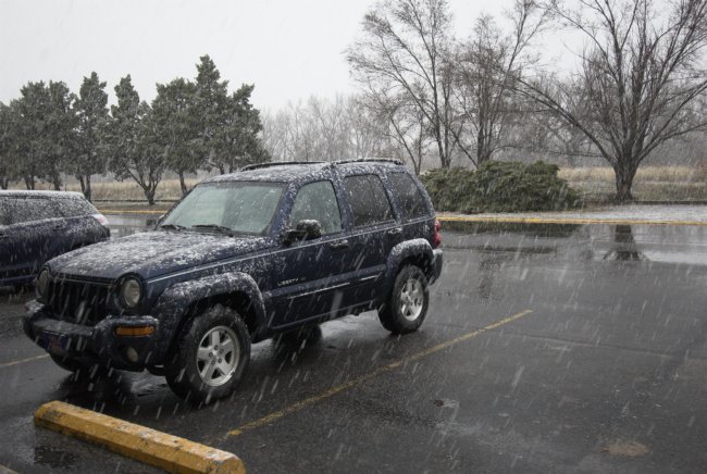
Spring Snowstorm Chase: April 10, 2008 [post 11]
Some images from this afternoon’s snowstorm around North Platte, NE:


Spring Snowstorm Chase: April 10, 2008 [post 10]
5.6" officially at North Platte airport. LSR issued by North Platte mentioned 5.6" measured snowfall with this storm as of 8:00pm CDT. That sounds about right. Snow depth is a bit less than that though given the amount of melting through. the day. On the backside of this storm, still seeing moderate snow here in North Platte late in the evening. Will get a few pics uploaded here soon. The plan for me is to leave here very early in the morning so I can make it back to Dodge by late morning/midday Friday.
Spring Snowstorm Chase: April 10, 2008 [post 9]
Not a whole lot of significant excitement to report this afternoon. There has been probably 4-5" of snowFALL around North Platte, but current snowDEPTH is barely 3". I drove around town and photographed some snow scenics around a couple of the city parks here in North Platte. Then I drove northwest of town about 6-8 miles or so. The wind started to pick up quite a bit around 3pm, gusting to 40 mph at times. Blowing snow was rather widespread over the open areas and really increased the snowpack over the east-west and southeast-northwest oriented roads. Some near-blizzard conditions were experienced at times. I am back at the motel room now, as it is still snowing moderately out there. It sure looks like north of here into the Sandhills got the most snow based on radar data. Later on this evening I’ll post a few pics.
Spring Snowstorm Chase: April 10, 2008 [post 8]
1.5 to 2 inches of slushy accumulation so far. Despite how heavy the snow has been falling at times this morning, the accumulation has not been all that impressive, particularly due to the warm ground and indirect insolation from the fairly high early-mid April sun angle. It’s just tough to accumulate snow rapidly this time of year unless it is really coming down with like 35 dBZ radar echoes. If it was 5 to 8 degrees colder, we’d probably be at around 4 or 5 inches of snow. It’s been stuck at 34F degrees the whole time so far, which is really cutting down on the accumulation potential. Snowfall-liquid ratio is probably 8:1 or so. 0.31" of precipitation has fallen since it has changed over to snow according to the North Platte ASOS… that equates to roughly a 6 or 7 to 1 ratio. Pretty weak.
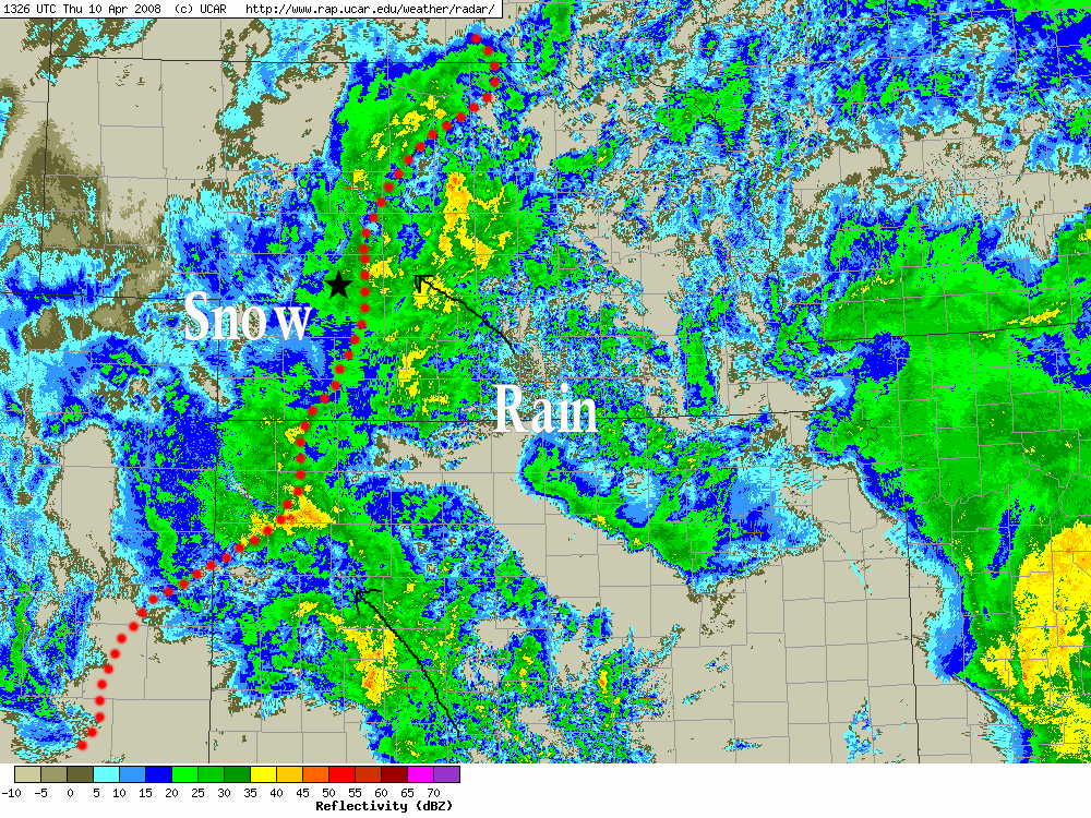
Spring Snowstorm Chase: April 10, 2008 [post 7]
Regional radar image. Dotted red line represents the rain/snow line. This is a very impressive radar image. There is going to be a LOT of snow where I’m at!!:
Spring Snowstorm Chase: April 10, 2008 [post 6]
Rain has changed to snow in North Platte. I drove west about 20 miles on I-80 to see where the rain/snow line was at about 715am or so. It was 36F in North Platte when I left with light rain. By the time I reached mile marker 160, I was getting large snow flakes, but then it changed back to rain by about marker 158… this was likely due to precipitation intensity. As I was driving back, the temperature was holding steady about 34F and the rain was very chunky… about 75% melted snow as it was reaching the ground. As I got back to North Platte, it was almost entirely back to all snow as precipitation rate was fairly intense. So, as I type, I look out the motel window at heavy wet snow now finally. Now let’s commence the accumulation!