 Freezing drizzle to develop later tonight. Current surface map shown in Img 1, as of 17z (11 am), revealed cold airmass in place across pretty much all of Kansas now as of midday today. Currently sitting at 32 degrees here in Dodge, and we will be lucky to rise 3 or 4 more degrees. By evening, low level winds just off the surface will increase out of the south and southeast, creating necessary lift for drizzle formation.
  The best layer to see this is between 900 and 850mb for a Dodge City elevation; I like using 875mb from the NAM model to see this shallow near-surface layer forcing (shown in Img 2). A nice thermal boundary will be just southeast of Dodge with completely saturated air. This is about the time I go in to work tomorrow morning, so I hope the roads won’t be too bad. Saturday night and beyond, it still looks like a complicated mess, as no less than 4 short-wave disturbances will rotate through a mean larger-scale trough across the Southwest (Img 3). Needless to say, it’s a complicated forecast as each of these waves will have an impact upon each other in how they grow/interact as they evolve through the trough.
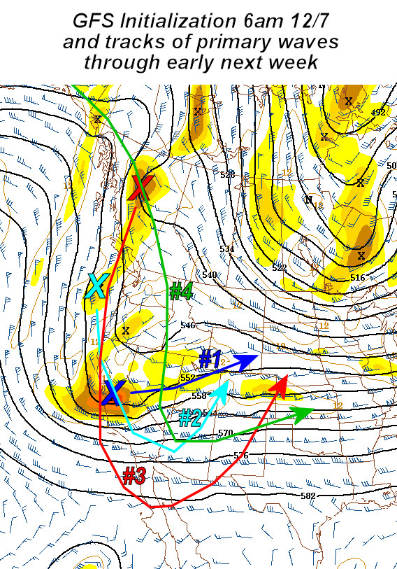
disclaimer: "The meteorological
views/forecast
thinking expressed are those solely of the author of this blog
and do not necessarily represent those of official National Weather Service forecast products,
therefore read and enjoy at your own risk and edification!"
and do not necessarily represent those of official National Weather Service forecast products,
therefore read and enjoy at your own risk and edification!"
December 7, 2007
Great Plains Winter Storm Dec 8-10 [post 2]
No Comments »
No comments yet.
RSS feed for comments on this post. TrackBack URL