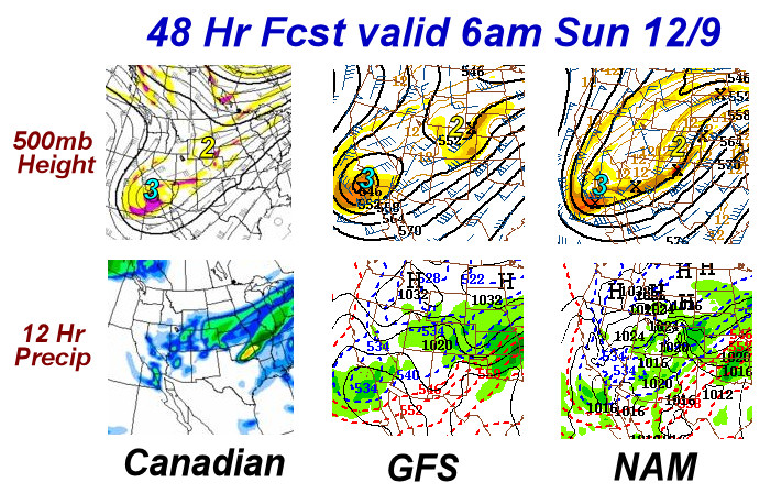
 Could wave #3 be "the event" for Southwest Kansas? In Img 3 of the previous post, I numbered the individual waves and their tracks from the GFS forecast that will rotate through this large scale trough over the next several days. In this post, I show a comparison among the Canadian, GFS, and NAM models with the evolution of both of these systems. It now appears that the 2nd wave that moves through late Saturday evening through early Sunday…will not be that
  big of a deal for Southwest Kansas, other than the prolonged freezing drizzle Saturday. It now looks like the third wave that digs way down into Baja, closes off, and then slowly ejects out late Monday into early Tuesday…may be a fairly substantial precipitation producer around here….perhaps in the form of freezing rain — and maybe quite a bit of it. Will post a little more about this early-week "main event" later on tonight when new model data comes in. In the meantime, it’s 30°F outside as I speak, and freezing drizzle should be developing around or shortly after midnight.
disclaimer: "The meteorological
views/forecast
thinking expressed are those solely of the author of this blog
and do not necessarily represent those of official National Weather Service forecast products,
therefore read and enjoy at your own risk and edification!"
and do not necessarily represent those of official National Weather Service forecast products,
therefore read and enjoy at your own risk and edification!"
December 7, 2007
Great Plains Winter Storm Dec 8-10 [post 3]
No Comments »
No comments yet.
RSS feed for comments on this post. TrackBack URL